


National forecast for Tuesday, May 26
Fox News senior meteorologist Janice Dean has your FoxCast.
Get all the latest news on coronavirus and more delivered daily to your inbox. Sign up here.
Homeowners in one Texas neighborhood spent their Memorial Day cleaning up after severe storms spawned a tornado on the northwest side of San Antonio.
The National Weather Service (NWS) office in Austin/San Antonio said that a damage survey conducted on Monday confirmed that an EF-1 tornado touched down Sunday night in the Wildhorse subdivision of San Antonio.
Forecasters said that the tornado had maximum sustained winds of 100 mph.
WHERE ARE TORNADOES MOSTLY LIKELY TO HAPPEN IN MAY?
A tornado warning was issued for Bexar County as the storm moved through. A video showed clouds and lightning in the San Antonio suburbs while a severe thunderstorm watch was in effect for the region.
Residents in the area said that the storm tore off roofs, and toppled fences and trees.
"There was glass blown out from the window and it just spewed everywhere across the countertops and it was really bad," Ryan Webb told FOX29 San Antonio. "The neighbor's roof completely dismantled and flew through our window and landed here. Our whole roof has a big hole in it, too."
A number of vehicles in the street also were damaged by plywood that flew through the neighborhood.
According to the National Severe Storms Laboratory (NSSL), the most common and practical way to determine the strength of a tornado is to estimate wind speeds by assessing the damage caused. The Enhanced Fujita Scale, or EF Scale, which became operational on Feb. 1, 2007, is used by the NWS to assign tornadoes a "rating" based on estimated wind speeds and related damage.
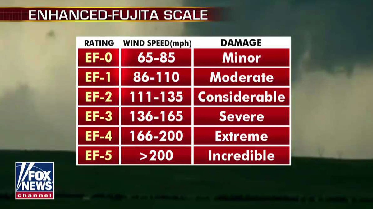
The ratings of tornadoes on the Enhanced-Fujita Scale. (Fox News)
According to the NWS forecast office in Norman, Okla., the EF scale is still a set of wind estimates based on established damage indicators. Those indicators include damage to different types of structures such as barns, mobile homes, trees and schools.
Tornadoes that are rated EF-1 have estimated wind speeds between 86 and 110 mph and create "moderate" damage."
WHY DO TORNADOES OCCUR AND HOW DO THEY FORM? WHAT YOU SHOULD KNOW
Forecasters said there was also a microburst on Tally Road in San Antonio, which caused significant damage as well.

The forecast for Tuesday across the nation. (Fox News)
The threat of more storms returns again on Tuesday, as showers and thunderstorms will produce locally heavy rain across the Plains and Mississippi Valley, according to Fox News senior meteorologist Janice Dean.
CLICK HERE FOR MORE WEATHER COVERAGE FROM FOX NEWS
The front is forecast to continue meandering along the Mississippi Valley over the next couple of days, according to the NWS Weather Prediction Center (WPC).
"Locally heavy rainfall is expected, which could cause flooding and flash flooding," forecasters said.
CLICK HERE FOR THE FOX NEWS APP
The Storm Prediction Center (SPC) said the greatest threat for severe storms includes parts of Iowa, southern/eastern Minnesota and western Wisconsin. A few tornadoes are possible on Tuesday.
Fox News' Janice Dean contributed to this report.