


Fox News Flash top headlines for August 13
Fox News Flash top headlines are here. Check out what's clicking on Foxnews.com.
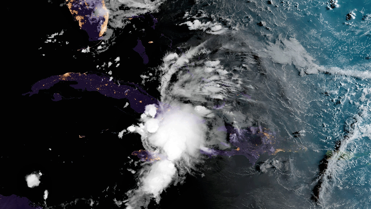
Tropical Depression Fred dumped heavy rains on central Cuba Friday night as it churned in the Caribbean about 175 miles southeast of Key West, Fla.
The National Hurricane Center reported it was moving due west at 12 mph, with maximum sustained winds of 35 mph as of 8 p.m.
TROPICAL DEPRESSION FRED: FLORIDA EMERGENCY MANAGEMENT PREPARES AS STORM NEARS
The storm was expected to travel west-northwest overnight, according to forecasters.
On its forecast track, Fred is projected to move along northeastern and central Cuba through Friday evening, near the Florida Keys on Saturday and move close to the west coast of Florida on Sunday.
Fred's maximum sustained winds were near 35 mph with higher gusts, though strengthening is expected to take place over the next couple of days and the agency said Fred could become a tropical storm again later on Friday.
Tropical storm warnings were in effect for the Florida Keys west of Ocean Reef to the Dry Tortugas and Florida Bay, and tropical storm watches were issued for the southwest coast of Florida from Englewood south and east to Ocean Reef.
Tropical storm conditions are possible in the watch area in Cuba through Friday night, are anticipated across the Florida Keys' warning area on Sunday and are possible in the watch area in Florida on Saturday.
Fred is expected to produce 1 to 3 inches of rain with isolated maximum totals of 5 inches over Cuba and the eastern Bahamas; and 3 to 5 inches with isolated maximum totals of 8 inches over the western Bahamas.
TROPICAL STORM FRED BECOMES SIXTH NAMED STORM OF ATLANTIC HURRICANE SEASON
From Friday into Monday, 3-7 inches of rain was anticipated across the Keys, Southern and Central Florida, north toward the Big Bend with isolated maximum totals of 10 inches.
The NHC said heavy rainfall in the region could worsen ongoing minor to isolated moderate river flooding over northern Florida and lead to lead to areal, urban and small stream flooding.
From Sunday on, heavy rain and flood impacts could also extend inland into the Southeast, southern and central Appalachians and Piedmont region.
The NHC advised that interests in the Bahamas, Cuba and the Florida Peninsula monitor Fred's progress, noting that additional watches and warnings would likely be required for portions of these areas later Friday.
Fred formed south of Puerto Rico late Tuesday night – also impacting the U.S. Virgin Islands – and weakened from a tropical storm to a tropical depression force on Wednesday night as it swept over Haiti and the Dominican Republic through Thursday.
The storm knocked out power for hundreds of thousands of households in the Dominican Republic and around 13,000 in Puerto Rico.
Dominican Republic officials were also forced to shut down part of the country’s aqueduct system, due to flooding from the storm.
CLICK HERE TO GET THE FOX NEWS APP
Fred is the sixth named storm of the 2021 Atlantic hurricane season and the first in the month of August.
A seventh is right on its heels, according to the National Weather Service, headed toward the Virgin Islands and Puerto Rico for an expected Sunday landfall. That one has not yet been named.
The Associated Press contributed to this report.