


Fox News Flash top headlines for August 11
Fox News Flash top headlines are here. Check out what's clicking on Foxnews.com.
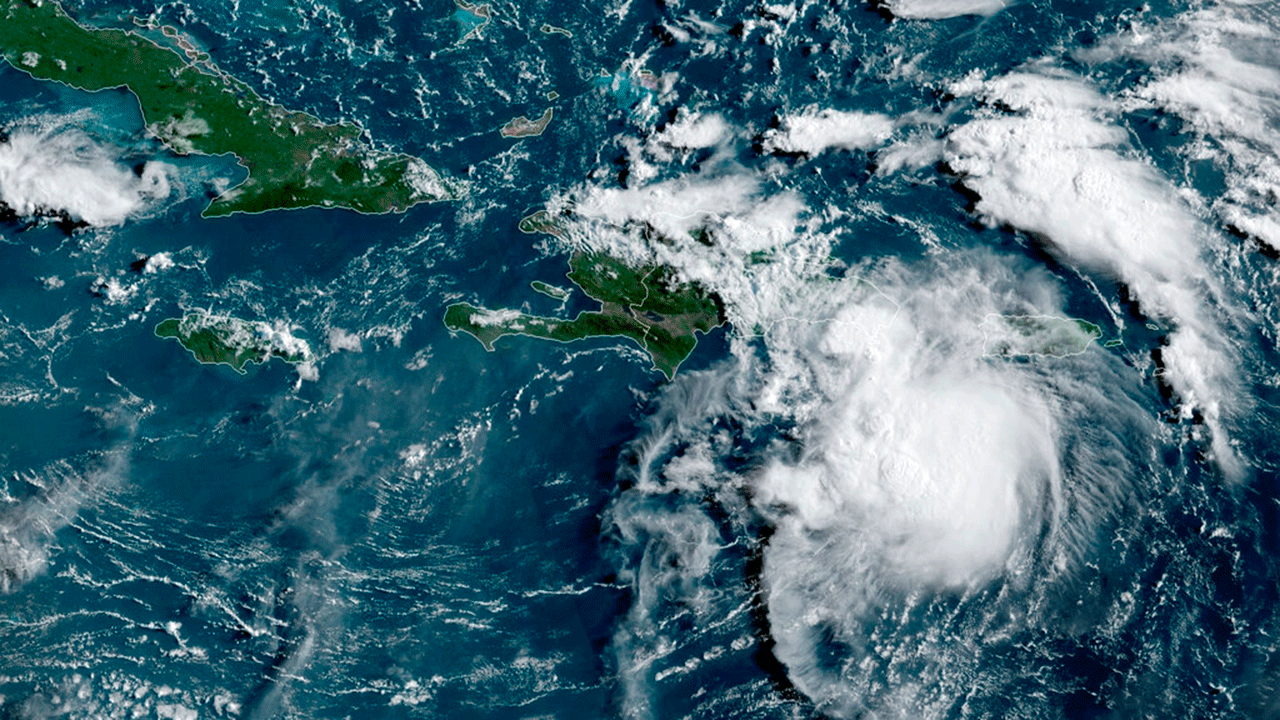
Tropical Storm Fred formed south of Puerto Rico late Tuesday night and was moving toward the Dominican Republic and Haiti on Wednesday.
Forecasters warned residents of heavy rains, flooding and mudslides.
2021 HURRICANE SEASON WILL BE EVEN MORE ACTIVE THAN PREVIOUSLY FORECAST: NOAA SCIENTISTS
Power outages had already been reported in Puerto Rico, and Luma – the company in charge of the transmission and distribution system – issued warnings to those who depend on electricity for life-saving medical devices.
"Puerto Rico’s system ... continues to be very fragile," the company said.
Puerto Rico Gov. Pedro Pierluisi said government agencies would close and some gas stations in the country had shut down after running out of fuel, according to officials.
Eight shelters were opened and residents were urged by Puerto Rico's emergency management commissioner, Nino Correa, to "not wait until the last minute to mobilize."
The National Hurricane Center (NHC) wrote in a Wednesday Facebook update that the center of Fred was positioned over the Caribbean Sea about 50 miles southeast of Santo Domingo, the Dominican Republic's capital city.
The storm was reportedly moving to the west-northwest near 16 mph with maximum sustained winds near 40 mph and tropical-storm-force winds extending outward up to 45 miles from the center.
The city of La Romana in the Dominican Republic recently reported sustained winds of 35 mph.
A general west-northwestward motion is expected to begin later Wednesday and continue for the next few days.
HEAT WARNINGS AND ADVISORIES IN EFFECT ACROSS THE US
Fred is forecast to be centered over or near Hispaniola later Wednesday, near the Turks and Caicos Islands and the southeastern Bahamas on Thursday and then north of the northern coast of central Cuba on Friday.
The NHC noted that some weakening of the storm is "likely" as Fred "interacts" with Hispaniola and that tropical storm conditions are expected in portions of the Dominican Republic on Wednesday morning and along the northern coast of Haiti, the Turks and Caicos and the southeastern Bahamas later in the day.
"Interests elsewhere" in Haiti, the Bahamas, eastern and central Cuba and Florida were instructed to monitor the progress of the system and updates to the forecast.
"Interests in Florida should also monitor updates to the forecast as there is a risk of wind and rainfall impacts beginning Friday in the Keys and spreading northward through portions of the Peninsula and the Panhandle this weekend. However, it is too soon to determine the exact timing, location and magnitude of any potential impacts," the agency said.
"While it’s too soon to determine exact impacts, Floridians should review their disaster plans & follow @FLSERT for updates," Florida Gov. Ron DeSantis tweeted Wednesday.
A tropical storm warning is in effect for the Dominican Republic's south coast from Punta Palenque eastward and on the north coast from the Dominican Republic and Haiti border eastward.
Additionally, a tropical storm watch is in effect for the Turks and Caicos Islands and the southeast Bahamas.
CLICK HERE TO GET THE FOX NEWS APP
The storm was expected to produce rainfall of 2 to 4 inches over Puerto Rico and the Dominican Republic with isolated maximum totals of 6 inches.
Haiti, the Turks and Caicos Islands, eastern Bahamas and eastern Cuba were expected to see 1 to 3 inches of rain with isolated maximum totals of 5 inches.
Fred is the sixth named storm of the Atlantic hurricane season.
The Associated Press contributed to this report.