


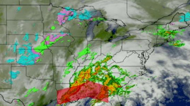
Holiday travelers across America could see their plans derailed by a mixture of Gulf Coast thunderstorms expected to travel north, predicted snowfall in the Great Lakes, and rain on the East Coast.
The National Weather Service predicts Christmas Eve precipitation from Missouri to Michigan, with rain turning into snow in some areas.
"It's really a wide-ranging storm system with several weather phenomena that could cause delays across the eastern portion of the country," Mike Musher, a National Weather Service meteorologist, told FoxNews.com on Tuesday. "Unfortunately, it's happening at one of the most-traveled days of the year."
In New York, light to moderate rainfall will give way into a soaking storm Christmas Eve, and rain was expected through the day in some New England states as well, Musher said.
Up to three inches of snow is expected in parts of Illinois, which could cause headaches at Chicago's O'Hare and Midway international airports. Officials there were preparing for potential delays and cancellations, particularly with more people expected to fly this holiday season.
"I'd be nervous about the possibility of not being able to get out," Chicago area meteorologist Charles Mott told the Associated Press. "I would definitely make plans about possibly staying put or doing something else."
Chicago's airports alone are projected to service 4.2 million travelers during the two weeks surrounding Christmas, while 90 million are expected to get to their destination by car, helped by drastically lower gas prices than at this time last year.
By Tuesday afternoon, FlightAware.com reported more than 3,600 flight delays in the U.S., with more than 600 flights canceled. Many of the affected flights were reported in New York, Philadelphia and Baltimore airports.
Musher said the storm system will begin clearing out on Christmas, though some areas of New England and the Great Lakes region may still suffer from rainfall. By the weekend, however, temperatures in the eastern part of the country will rise to five to 10 degrees above normal, and conditions will be sunny by Saturday, he said.
Also Tuesday, severe storms swept across the South, killing at least four people, damaged homes, businesses and cars, and knocked out power to thousands.
The storms led to some delays at Hartsfield-Jackson Atlanta International Airport — though airport spokesman Reese McCranie said in an email he was not aware of any cancellations. He said the airport did not expect a ground stop.
Cold and snowy conditions affected travel across America Tuesday.
Dozens of flights in and out of Philadelphia International Airport were canceled and others saw delays of about two hours due to bad weather and low clouds.
Just west of Green Bay, Wisconsin, a school bus was involved in three-vehicle crash on snow-covered, slick roads. No serious injuries were reported.
In eastern Colorado, Interstate 70 was shut down into Kansas for eight hours because of strong winds and blowing snow. Farther west, blowing snow also led to part of U.S. Highway 285 being closed at some points Tuesday.
Parts of western South Dakota saw snow accumulations of a foot or more through Tuesday morning. Higher elevations in the Black Hills got close to 2 feet.
But not all winter enthusiasts were so lucky.
Snow isn't expected in other parts of South Dakota until Friday. Sioux Falls resident Alana Amdahl said she's disappointed about the lack of snow projected for Christmas.
"We live in South Dakota for a reason," said Amdahl, 27. "We don't have palm trees to put Christmas lights on, we have evergreens. Of course, we need snow. It can melt after the new year."
Snow was expected even in parts of Hawaii. A blizzard warning was in effect through Wednesday evening for the summits of Mauna Kea and Mauna Loa on the Big Island of Hawaii, where the National Weather Service says up to 8 inches of snow could accumulate above 11,500 feet. Snow on the mountains is common, but a blizzard is unusual.
FoxNews.com's Karl de Vries and The Associated Press contributed to this report.