


Fox News Flash top headlines for June 22
Fox News Flash top headlines are here. Check out what's clicking on Foxnews.com.
California's Willow Fire has scorched nearly 3,000 acres since igniting last week and evacuations and concerns mounted Tuesday in and beyond Monterey County.
The 2,848-acre wildfire, located in Monterey's Los Padres National Forest, was still 0% contained, though the Los Padres National Forest’s U.S. Forest Service said on social media that cooler temperatures and an increase in humidity had helped the efforts of the now more than 510 people working to douse the flames.
CALIFORNIA'S WILLOW FIRE SPREADS AS RECORD DROUGHT, HEAT CONTINUE TO GRIP STATE
"Cooler temperatures and an increase in relative humidity today has given firefighting resources an opportunity to initiate a direct attack on the eastern edge of the fire at Marble Creek Trail as well as continuing to strengthen contingency lines around the fire perimeter," the agency wrote.
Evacuation Warnings and Orders were issued for the surrounding regions and Monterey County Weekly reported that 100 homes and 25 commercial buildings were threatened by the fire.

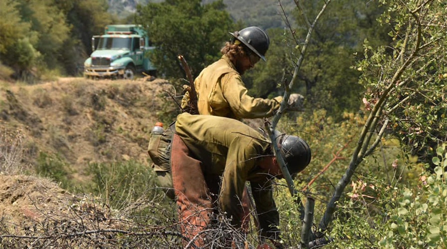
Firefighters work to combat the Monterey County, Calif. Willow Fire (U.S. Forest Service - Los Padres National Forest)
In a description of the incident, the Los Padres National Forest’s U.S. Forest Service said that the Monterey County Sheriff’s Office has gone into Unified Command with Los Padres National Forest and California Interagency Incident Management Team 11.
"Moderate to active fire behavior is expected toward Arroyo Seco, as well as northerly and southerly spread due to slope runs. Firefighters on the ground are making a strong effort to stop further spread to the north and west flank of the fire line with the assistance of air support," the statement read, also noting that crews are continuing to prepare for structure defense in the Tassajara Zen Center and the Arroyo Seco campground area and have been scouting ridges where previous fire control lines were built to possibly utilize them again.
The cause of the fire remains unknown.
While firefighters worked amidst rugged and steep terrain, Southern California firefighters were almost working to extinguish the smaller 410-acre Inyo Creek Fire.
Amidst wind gusts of 35 mph, the fire grew overnight on Monday, fanning the flames down-canyon into Lone Pine Creek and triggering additional evacuations of residents at Olivas Ranch, Whitney Portal Reserve, and all residents on Whitney Portal Road North of Horseshoe Meadow Road.
According to an incident report from the Inyo National Forest U.S. Forest Service, a Type 2 Incident Management Team was on order to take over the incident on Wednesday and the fire went into Unified Command with CAL FIRE due to the threat to structures and state lands.
An aerial effort and "Air Attack" was planned for Tuesday would retardant drops and multiple roads and trails were closed to the public.
The Inyo Creek Fire, caused by lightning last Friday,
CLICK HERE FOR THE FOX NEWS APP
The Whitney Portal trailhead, known as a popular route to Mt. Whitney – the tallest peak in California and the highest peak in the contiguous U.S – was one of the trails closed.