


Hurricane Isaias makes landfall in North Carolina
Reports of damage as storm hits land; Rick Leventhal has the latest.
Hurricane Isaias was downgraded to a tropical storm early Tuesday, just hours after roaring ashore in North Carolina, triggering floods and property damage, according to the National Hurricane Center (NHC).
In addition to the flooding, the storm sparked five residential fires in Ocean Isle Beach, Debbie Smith, the town’s mayor, told Wilmington's WECT-TV. About 30 people were displaced due to a fire at a condominium complex in Surf City, located about 80 miles north of where the storm originally made landfall.
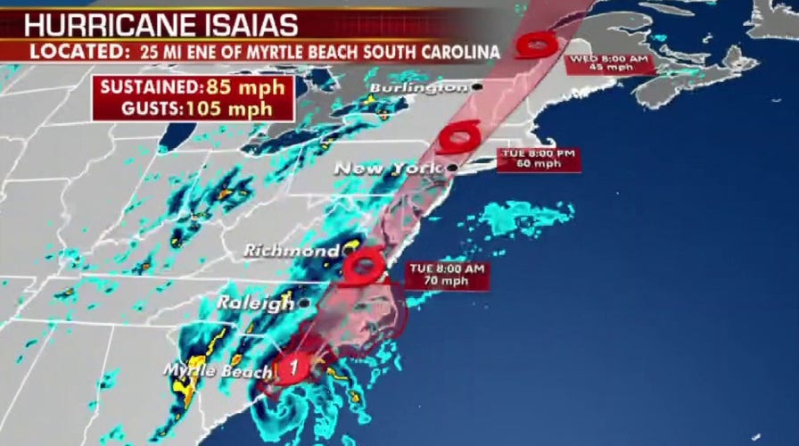
The storm had originally made landfall around 11:10 p.m. near Ocean Isle Beach, N.C., with maximum sustained winds of 85 mph.
“Now that the center has moved further inland into east North Carolina, the winds are now coming back down, so it has been downgraded back to a tropical storm," said Robbie Berg, a hurricane specialist with the National Hurricane Center.
ISAIAS REGAINS HURRICANE STRENGTH, EXPECTED TO MAKE LANDFALL TONIGHT
As of 4 a.m. Tuesday morning the storm was about 10 miles east-northeast of Rocky Mount, N.C., with maximum sustained winds of 70 mph -- just 4 mph shy of officially being deemed a hurricane. It was moving north-northeast at 26 mph.
Berg said Isaias isn't expected to weaken much and could still continue to bring down trees and cause power outages as it moves north up the mid-Atlantic and New England coastline. Hundreds of thousands of power outages were reported by Duke Energy as heavy rain and winds struck the Wilmington area in North Carolina.
“We don’t think there is going to be a whole lot of weakening, we still think there’s going to be very strong and gusty winds that will affect much of the mid-atlantic and the Northeast over the next day or two,” Berg said.
He added that rainfall will continue to be a major issue.
Isaias had made landfall in North Carolina on Monday night after strengthening into a Category 1 hurricane, the National Hurricane Center reported. The NHC warned oceanside residents to brace for storm surge up to 5 feet and up to 8 inches of rain as it moves up the coast.
“All those rains could produce flash flooding across portions of the eastern Carolinas and mid-Atlantic, and even in the northeast U.S.,” said Daniel Brown, senior hurricane specialist at the NHC.
The NHC warned strong winds and heavy rainfall are likely in those areas during the day on Tuesday.
Video taken on Twitter showed heavy winds battering the area of North Myrtle Beach, S.C., located about 20 miles southwest of where the hurricane made landfall.
Authorities in the city ordered swimmers out of the water to avoid rough surf and strong rip currents and power started to flicker at beachfront hotels by nightfall. A pier in Myrtle Beach recorded its third-highest water level since it was set up in 1976.
Before the recent downgrade, Isaias (pronounced ees-ah-EE-ahs) had been bumped up from a tropical storm to a Category 1 hurricane late Monday night. As of 11 p.m., the storm was centered about 40 miles east northeast of Myrtle Beach and was moving north northeast at 22 mph.
The NHC said hurricane conditions were spreading onto the coast of Eastern South Carolina and Southeastern North Carolina. A hurricane warning was issued from the South Santee River in South Carolina to Surf City, N.C. The Hurricane Center said it expected the storm to make landfall early Tuesday near southern North Carolina.

People walk on the flooded Sea Mountain Highway in North Myrtle Beach, S.C., as Isaias neared the Carolinas on Monday night, Aug. 3, 2020. (Jason Lee/The Sun News via AP)
There is also a potential risk of tornadoes from eastern Virginia northeastward into southern New England on Tuesday, according to the NHC.
Meanwhile, a storm surge warning was in effect from Ocracoke Inlet to Oregon Inlet N.C. The warning means there is a danger of life-threatening inundation from rising water moving inland from the coastline.
"This is a life-threatening situation," the NHC said. "Persons located within these areas should take all necessary actions to protect life and property from rising water and the potential for other dangerous conditions. Promptly follow evacuation and other instructions from local officials."
President Donald Trump on Monday described Isaias as “very serious."
TROPICAL STORM ISAIAS COULD HIT THE CAROLINAS AT NEAR-HURRICANE STRENGTH
“Storm surge and inland flooding are possible and everyone needs to remain vigilant until it passes," Trump said.
The hurricane season has come at a time when many people in the Southeast are already impacted by the coronavirus outbreak.
North Carolina Gov. Roy Cooper warned residents on Monday that the storm could be dangerous regardless of its strength. He urged those evacuating to turn to shelters as a last resort, citing coronavirus risks and the need to operate shelters at reduced capacity to allow for social distancing.
“Whether it’s labeled a tropical storm or a hurricane, you should take this storm seriously, and make sure your family is ready,” Cooper said.
As the storm makes its way up the coastline, New York and western New England are expected to get up to 6 inches of rain. New York City is preparing for probable flooding by putting up barriers to protect the South Street Seaport.
“I want to encourage all New Yorkers [to] take this storm seriously,” Mayor de Blasio said at a waterfront news briefing on Monday. “Please take precautions. Please look out for your neighbors. If anyone needs help, make sure you’re there for them because this is the kind of thing that comes on fast and people need to be ready.”
CLICK HERE TO GET THE FOX NEWS APP
Isaias killed two people in the Caribbean and roughed up the Bahamas but remained at sea as it brushed past Florida over the weekend.
Fox News' Nick Givas and The Associated Press contributed to this report