


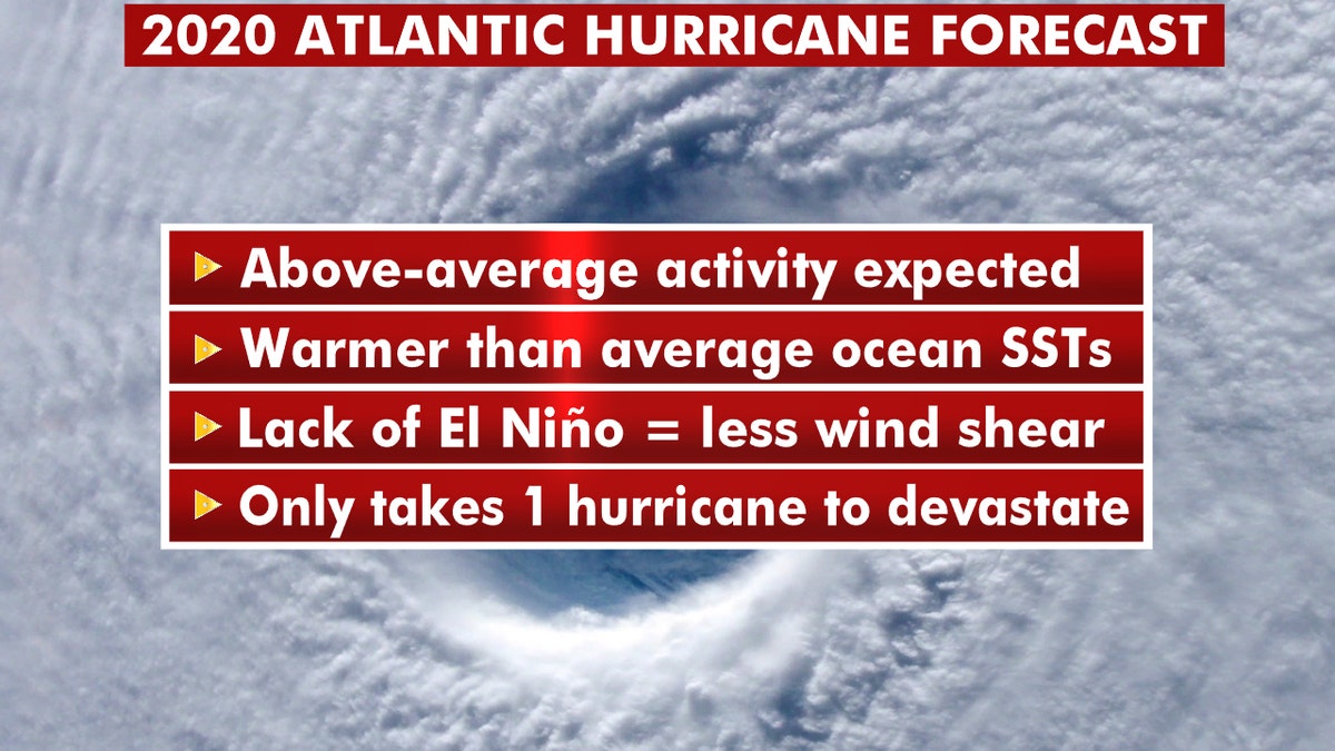
There are some key reasons why the National Oceanic and Atmospheric Administration is calling for "busy" months ahead during the 2020 Atlantic basin hurricane season.
On Thursday, federal government forecasters predicted 13 to 19 named storms, of which six to 10 will become hurricanes, with three to six of those becoming major hurricanes of Category 3, 4 or 5.
This forecast is well above the averages of 12 named storms, six hurricanes, and three major hurricanes.
HOW STRONG CAN HURRICANES GET? HERE'S A BREAKDOWN OF CATEGORIES AND THE SAFFIR-SIMPSON WIND SCALE
While the Atlantic Basin season officially runs June 1 through Nov. 30, the season kicked off early with Tropical Storm Arthur forming on May 16. It skirted eastern North Carolina and the Outer Banks without making landfall.
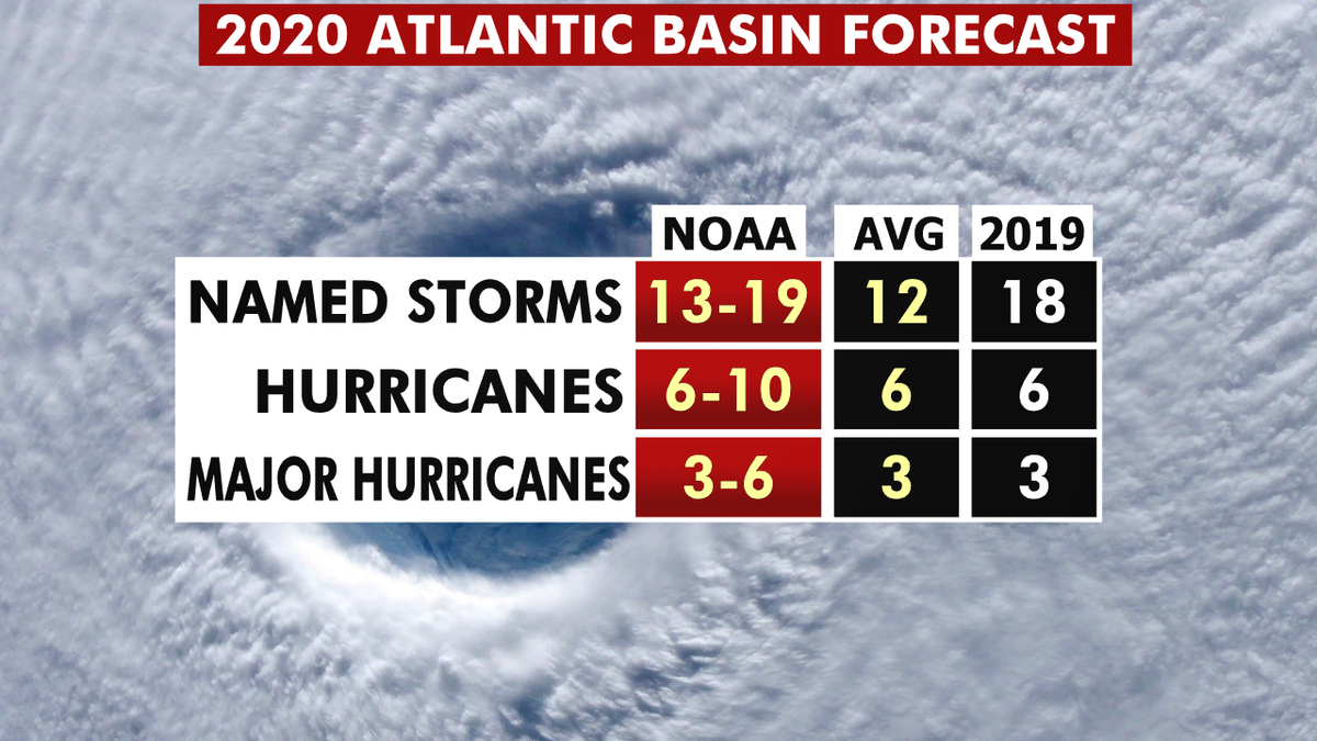
The 2020 hurricane season forecast from NOAA. (Fox News)
These three key indicators for hurricane activity in the Atlantic are pointing toward the above-average activity.
Sea Surface Temperatures
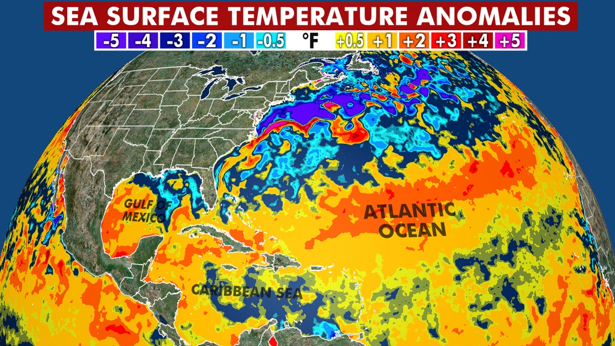
Warmer than average sea surface temperatures are expected to lead to an active Atlantic hurricane season in 2020. (Fox News)
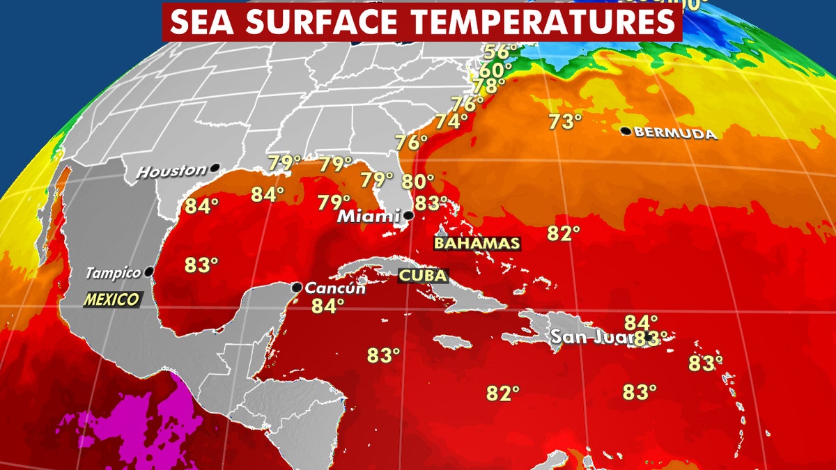
One of the biggest factors in tropical development is heat energy, which for hurricanes comes from warm sea surface temperatures (SSTs).
Generally, SSTs of 78-80 degrees Fahrenheit are needed for a hurricane to form, with warmer temperatures providing additional energy.
Warmer than average sea surface temperatures are expected to lead to an active Atlantic hurricane season in 2020. (Fox News)
Much of the Atlantic, Caribbean, and Gulf of Mexico are experiencing SSTs well above average. Assuming this warmth continues, it will provide plenty of additional fuel for hurricanes this year.
No El Niño This Season
Forecasters are looking closely at wind shear, which is varying wind speed and direction higher into the atmosphere.
Coronavirus pandemic changing the way Florida is preparing for hurricane season
Florida leaders face new obstacle in preparing for hurricane season.
High wind shear can greatly impede hurricane development and even weaken one that's well organized.
WHAT WAS THE WORST HURRICANE TO HIT THE US? HERE ARE THE COSTLIEST STORMS
When El Niño conditions are present in the Pacific Ocean, wind shear is higher across the Caribbean and Atlantic.
While hurricanes can still form, they tend to be weaker and less numerous in El Niño years.
Long-range forecasters anticipate neutral conditions (neither El Nino or La Niña) through late summer, with La Niña conditions possible in the fall. This would lead to even less wind shear in the Atlantic Basin to impede hurricane development.
U.S. Impacts
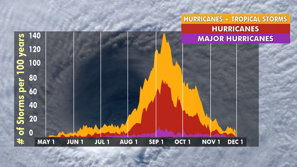
Hurricane season peaks from late August through early October. (Fox News)
On average, the mainland U.S. sees one to two hurricane landfalls each season. The 2019 Atlantic hurricane season saw landfalls of Hurricane Barry in Louisiana and Dorian in North Carolina.
While there is a forecast of above-average hurricane activity, this doesn't necessarily translate to more U.S. impacts.
CLICK HERE FOR MORE WEATHER COVERAGE FROM FOX NEWS
The year 2010 was the third most active season in record with 19 tropical storms and 12 hurricanes but had no U.S. hurricane landfalls.
What you should about this year's 2020 Atlantic hurricane season. (Fox News)
The 1992 season only had seven named storms, with the first in August, which turned out to be Hurricane Andrew.
Coastal residents must remember it only takes one hurricane landfall to impact them, and regardless of the forecast they should prepare every season.