


Isaias downgraded to tropical storm as it nears Florida coast
Isaias downgraded to tropical storm as it nears Florida coast; Meteorologist Adam Klotz reports.
Tropical Storm Isaias battered Florida's east coast with heavy rains Sunday and is now on track to be at near hurricane strength when it reaches the Carolinas.
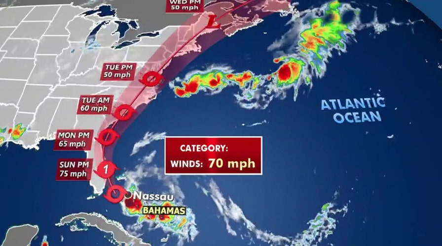
As of 11:00 p.m., the National Hurricane Center in Miami said the storm was located about 50 miles east of Cape Canaveral, Fla., and 365 miles south of Myrtle Beach, S.C. Maximum sustained winds have increased slightly to 70 mph as it continues to move north-northwest at a speed of 9 mph.
"Isaias is expected to be at near hurricane strength when it reaches the coast of northern South Carolina and southern North Carolina on Monday night, and strong tropical force winds are likely with hurricane conditions in the Hurricane Watch area." the NHC said.
ISAIAS STRENGTHENS SLIGHTLY AS IT CRAWLS UP FLORIDA COAST
The NHS said there was danger of "life-threatening" storm surge from Edisto Beach S.C. to Cape Fear, N.C. Those areas could see the water rise between 2 to 4 feet above ground level. Life-threatening storm surge is possible along the North Carolina coast from Cape Fear to Duck.
Residents in those areas are advised to follow guidelines from local emergency officials.
The storm was weakened from a hurricane to a tropical storm Saturday afternoon but it still brought heavy rain and flooding to Florida's Atlantic coast. Areas along Florida's eastern coast will see high winds and rain, but nothing that should cause major damage, said Fox News Chief Meteorologist Rick Reichmuth on "Fox & Friends Weekend."
With coronavirus cases surging in Florida recently, the added menace of a storm ratcheted up the anxiety. State-run virus testing sites closed in areas where the storm might hit because the sites are outdoor tents, which could topple in high winds.
“Don't be fooled by the downgrade,” Florida Gov. Ron DeSantis warned at a news conference after the storm impacted the Bahamas for hours.

Beachgoers pack Wrightsville Beach, N.C., Sunday, Aug. 2, 2020 as Tropical Storm Isaias moves along the Southeast Coast. (Travis Long/The News & Observer via AP)
TROPICAL STORM ISAIAS LASHES FLORIDA'S EAST COAST, NO LONGER EXPECTED TO REACH HURRICANE STRENGTH
The governor said the state was anticipating power outages and asked residents to have a week’s supply of water, food, and medicine on hand. South Florida, however, emerged from the storm with less damage than expected. Between 2 and 4 inches of rain fell in some areas and the storm knocked out power for a few hundred people, according to the Miami Herald.
As of 10 a.m. Sunday, 2,650 customers were without power in Palm Beach County and over 300 customers were out in Martin and St. Lucie counties.
Stacy Stewart, senior hurricane specialist at the hurricane center in Miami, said upper-level winds took some of the strength out of Isaias.
“We were expecting a hurricane to develop and it didn't,” Stewart said on Sunday. “It's a tale of two storms. If you live on the west side of the storm, you didn't get much. If you live east of the storm, there's a lot of nasty weather there.”
Tropical storm conditions are forecasted to spread throughout the rest of the east coast on Tuesday and early Wednesday. Significant flash and urban flooding are possible across portions of the Carolinas and mid-Atlantic with those areas potentially seeing up to eight inches of rain.
Southeast New York and much of New England could see up to six inches of rain, while coastal Georgia could see up to two inches.
CLICK HERE TO GET THE FOX NEWS APP
A hurricane watch and storm surge warning are in effect for portions of the Carolinas as of early Sunday evening. A tropical storm watch is in effect through Long Island Sound and additional updates will be issued on Monday, according to the NHC.
Fox News' Travis Fedschun, Rick Reichmuth, and the Associated Press contributed to this report