


A large and powerful Hurricane Teddy is set to make a direct impact in Atlantic Canada, but the storm's vast size is creating problems along the East Coast of the U.S.
The National Hurricane Center (NHC) said Tuesday that Hurricane Teddy is a Category 2 storm, packing maximum sustained winds of 105 mph and is located about 365 miles south of Halifax, Nova Scotia. The storm is moving north-northwest at 28 mph.
"Teddy forecast to bring heavy rain, strong winds and destructive waves to Nova Scotia," the NHC said in its 8 a.m. EDT update.
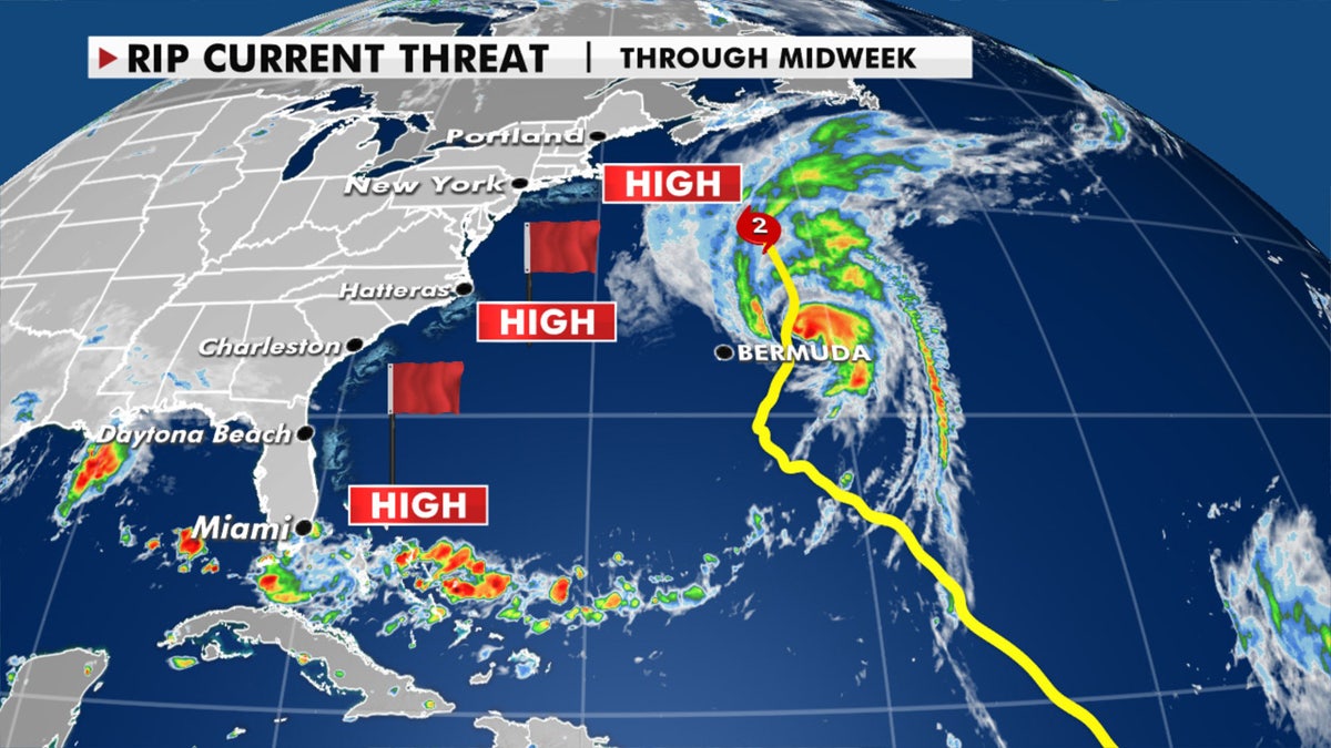
HURRICANE TEDDY BRINGING 'LIFE-THREATENING' RIP CURRENTS TO EAST COAST
Teddy will lose its tropical characteristic and transition to an extratropical storm impacting Atlantic Canada from Tuesday night into Wednesday.
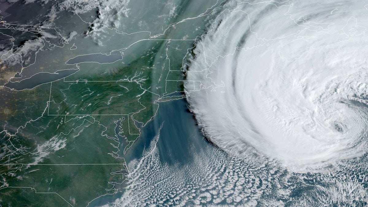
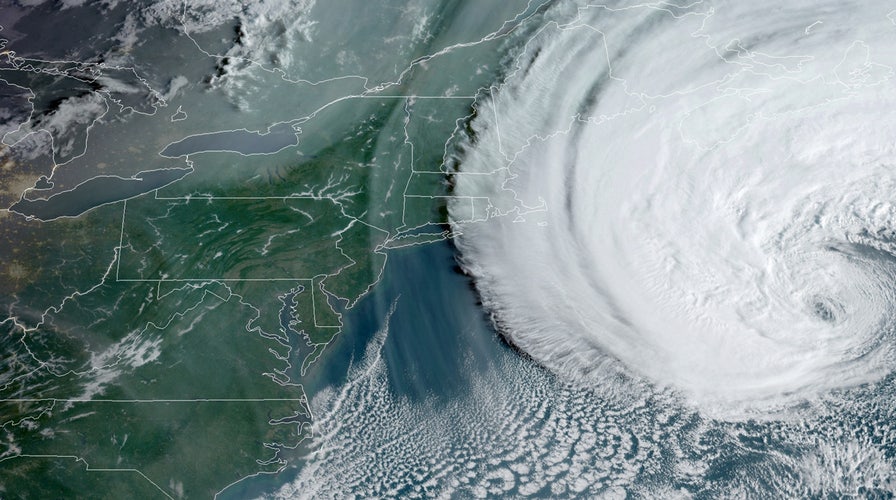
Hurricane Teddy as seen on Sept. 22, 2020 moving towards Atlantic Canada. (NOAA/GOES-East)
Tropical storm warnings are in effect for the Canadian Maritimes.
Teddy is a large hurricane, with hurricane-force winds extending outward up to 105 miles from the center of the storm while tropical-storm-force winds extend outward up to 400 miles.

The forecast track of Hurricane Teddy. (Fox News)
The large size of the storm is churning up the Atlantic, with dangerous conditions all along the East Coast.
Hurricane Teddy is creating dangerous conditions along the East Coast of the U.S. (Fox News)
"The results along the East Coast are going to be very big waves and very dangerous rip currents," Fox News Senior Meteorologist Janice Dean said on "Fox & Friends."
According to the National Weather Service (NWS) Weather Prediction Center (WPC) the "expansive circulation" of Teddy is causing the dangerous ocean conditions.
In addition to the high seas, Downeast Maine should get some rain and gusty winds from Teddy's western edge on Tuesday.
Swells from Hurricane Teddy in the Atlantic Ocean have been causing coastal flooding along the East Coast, according to forecasters.
Video filmed in Atlantic City, N.J., on Monday shows choppy surf and flooding along the beach.
The NWS Mount Holly office forecast wave heights of 52 feet in the Atlantic due to the hurricane and warned of surf heights of up to eight feet along the New Jersey coast.
CLICK HERE FOR MORE WEATHER COVERAGE FROM FOX NEWS
Elsewhere in weather across the nation, fall officially begins on Tuesday morning.

Forecast high temperatures for the first day of fall, Sept. 22, 2020. (Fox News)
The first official day of fall arrives at 9:30 a.m. EDT, and it certainly feels that way over parts of the East Coast with some areas feeling record cold lows Tuesday morning.
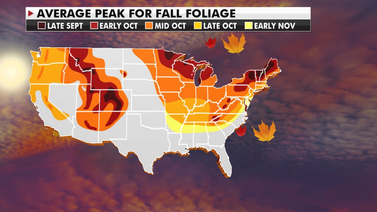
The average peak for fall season. (Fox News)
It will be a warm start to fall across the Central and Northern Plains, with afternoon highs Tuesday well into the 80s. The Northeast and Mid-Atlantic will be in the 60s and 70s, while Phoenix will be near 102.
Much needed rain will move into the Northwest and Northern Rockies.
CLICK HERE FOR THE FOX NEWS APP
Isolated showers and thunderstorms will also be possible across the four corners.

The national forecast for Sept. 22, 2020. (Fox News)
Some of these storms could contain lightning, and because it’s so dry, very little rainfall could mean a fire danger threat.

True Crime
The hottest stories ripped from the headlines, from crime to courts, legal and scandal.
By entering your email and clicking the Subscribe button, you agree to the Fox News Privacy Policy and Terms of Use, and agree to receive content and promotional communications from Fox News. You understand that you can opt-out at any time.
