


How strong can tornadoes get? Here's a breakdown
Tornadoes can cause varying levels of destruction. Here’s what levels of intensity they can reach.
Get all the latest news on coronavirus and more delivered daily to your inbox. Sign up here.
Born from thunderstorms, tornadoes can cause immense devastation, ripping apart homes and tossing cars like toys.
When weather conditions favor severe thunderstorms capable of producing tornadoes in a region, forecasters at the National Weather Service's (NWS) Storm Prediction Center (SPC) will issue what's known as a "tornado watch."
When the threat of damage caused by storms is particularly high, forecasters will issue what's known as a "PDS" watch, which stands for "particularly dangerous situation."
WHERE DO TORNADOES HIT THE MOST IN THE US? HERE ARE THE TOP 5 STATES
The SPC only issues such watches when forecasters believe there's the greatest risk of multiple strong or violent tornadoes in a watch area.
"Such watches are known as 'PDS' watches," the SPC states. "PDS tornado (TOR) watches are issued when the forecaster has high confidence that multiple strong (F2-F3 on the Fujita Scale) or violent tornadoes (F4-F5 on the Fujita Scale) will occur in the watch area."
When forecasters issue such warnings, they are usually written in all caps at the top of the watch with, "THIS IS A PARTICULARLY DANGEROUS SITUATION."
A PDS watch was issued on Easter weekend in April 2020, when a powerful line of storms led to a deadly tornado outbreak across the Southeast.
A study from the SPC states that most tornado-related deaths and damage are caused by twisters that are between EF2 and EF5 strength, with winds over 111 mph.
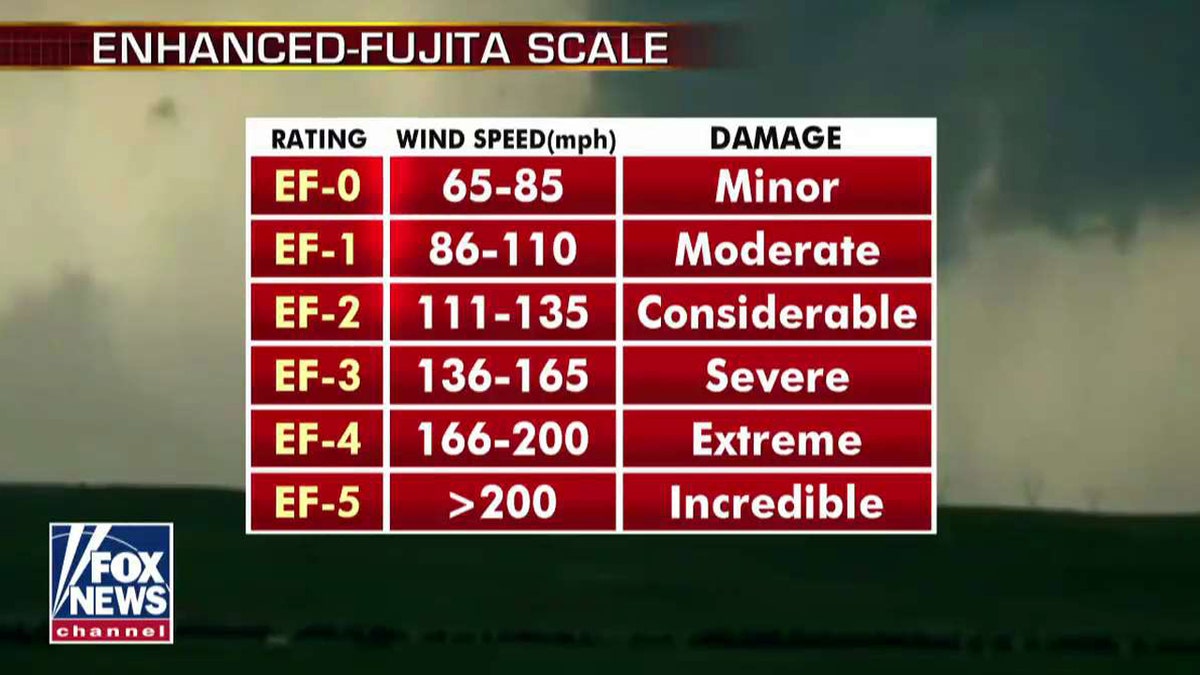
The ratings of tornadoes on the Enhanced-Fujita Scale. (Fox News)
EF2 to EF5 tornadoes represented less than 10 percent of all tornado reports between 1996 and 2005, but produced over 90 percent of the fatalities, over 80 percent of the injuries, and around 80 percent of the damage, according to the study's authors.
HOW STRONG CAN TORNADOES GET? HERE'S A BREAKDOWN
"It is clear that an outbreak of multiple strong or violent tornadoes is a major threat to life and property," the study's author's note. "This is the motivation for using enhanced wording in a PDS TOR watch when there is a particular threat of multiple strong or violent tornadoes occurring in the watch area, in order to highlight the unusually high threat level to the media, emergency managers, and general public."
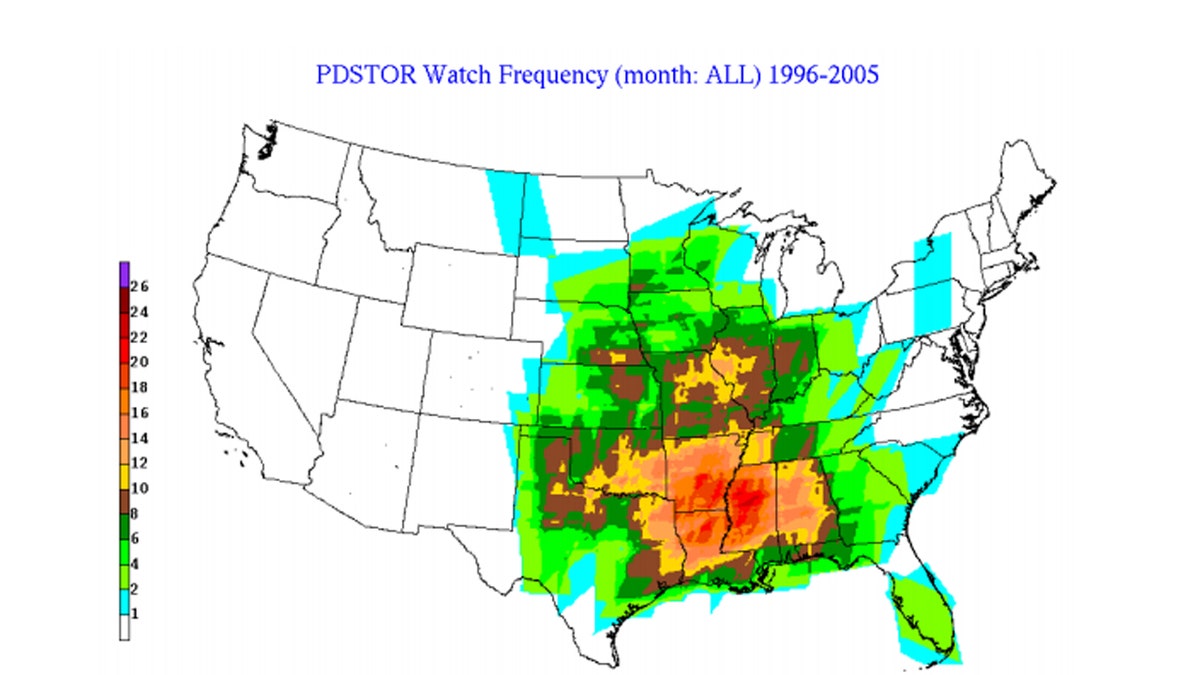
The number of PDS tornado watches from 1996-2005. The values on the map represent the total number of watches at a given location for the entire 10 year period of the SPC study. (NWS/SPC)
The strongly-worded warnings are only for more serious situations and rarely issued by forecasters. Between 1996 to 2005, only 7 percent of the 3,058 tornado watches issued by the SPC were PDS watches.
The greatest concentration for the PDS watches were in the lower Mississippi Valley, with a secondary maximum number of watches over the traditional “Tornado Alley” in the Great Plains coming in second.
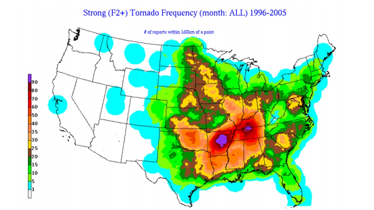
Locations of strong tornadoes between EF2 and EF5 strength between 1996 and 2005. The values on the man represent the total number of powerful twisters that occurred within 100 miles of a point on a 10 km grid, according to the SPC. (NWS/SPC)
“Since all tornadoes are potentially dangerous and most F2-F5 tornado events still occur in regular TOR (tornado) watches, the lack of PDS wording in a watch should not be interpreted as downplaying the threat to life and property,” the study’s authors said. “However, when the PDS wording is included the threat is to be considered as substantially higher.”
CLICK HERE FOR MORE WEATHER COVERAGE FROM FOX NEWS
It's also just not tornadoes that form PDS watches. The SPC said that PDS severe thunderstorm watches are issued when there's a threat of a high end "derecho" with widespread wind damage.
According to the National Oceanic and Atmospheric Administration's (NOAA) National Severe Storms Laboratory (NSSL), a derecho is a widespread, long-lived wind storm that is associated with a band of rapidly moving showers or thunderstorms.
"Although a derecho can produce destruction similar to that of tornadoes, the damage typically is directed in one direction along a relatively straight swath," the NSSL states. "As a result, the term “straight-line wind damage” sometimes is used to describe derecho damage."
CLICK HERE FOR THE FOX NEWS APP
In order for a cluster of thunderstorms to be defined as a derecho, a wind damage swath must extend for more than 240 miles and include wind gusts of at least 58 mph, or greater, along most of its length.
"While derecho winds typically are less than 100 mph, gusts as high as 130 mph have been recorded --- equivalent to those with strong EF2 tornadoes," the SPC notes.