


Get all the latest news on coronavirus and more delivered daily to your inbox. Sign up here.
After a weekend of record cold and some snow thanks to an appearance by the polar vortex, another chilly start is on tap for the week from the Midwest into the Northeast.
Well below normal temperatures, with a potential for record lows, are forecast to continue into Tuesday morning across much of the eastern two-thirds of the country.
"It is absolutely on the cool side," Fox News meteorologist Adam Klotz said Monday on "Fox & Friends."
THOUSANDS WITHOUT POWER IN MAINE AS POLAR VORTEX FREEZES BIG CHUNK OF US
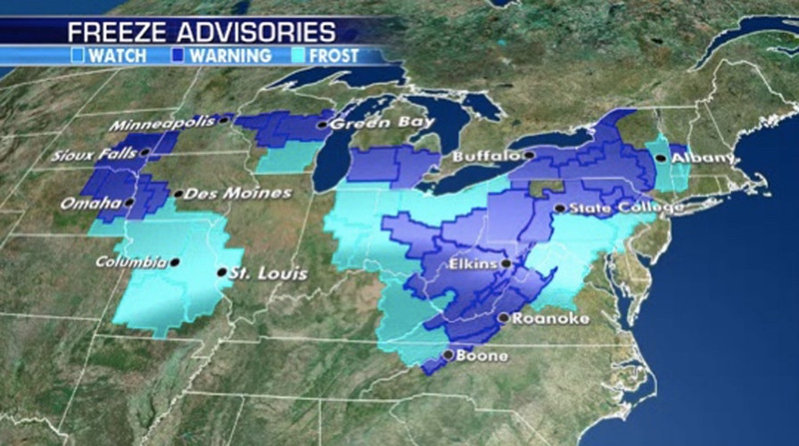
Freeze watches, warnings and advisories are in effect throughout the region as chilly temperatures are expected from the Midwest and Great Lakes to the interior Northeast.
Over Mother's Day weekend, parts of interior New England saw as much as six inches of snow.

Freeze watches, warnings and advisories stretch from the Midwest to the Mid-Atlantic and Northeast as unseasonable cold lingers in the region. (Fox News)
"No more snowfall but cold air is going to continue to linger across the Midwest, back up into the Northeast," Klotz said Monday. "Particularly on Monday, we're looking at a very cold Arctic air mass hanging over the Great Lakes, hanging over the Midwest."
Morning temperatures on Monday range from the 30's in the Midwest to Great Lakes, but the wind chill has some areas falling down into the 20s. In North Dakota, Fargo feels like 19 degrees on Monday morning.
RECORD SNOWFALL IN NORTHEAST SEES FIRST MAY SNOW IN CENTRAL PARK SINCE 1977
That cold air over the Plains and Upper Midwest shifts east over the next 24 hours towards the Northeast.
"This airmass then shifts on Tuesday over interior New England, stretching down the Atlantic coast," Klotz said Monday. "We'll see freeze watches, warnings, advisories for the next couple of nights."

Unseasonable cold is forecast to linger in the Midwest and Northeast through mid-week. (Fox News)
According to the National Weather Service's (NWS) Weather Prediction Center, a low-pressure system may bring the chance for thunderstorms to southern New England on Monday.
Behind the system, the WPC said another round of light wintry mixed precipitation or snow is also possible for the Central Appalachians and parts of the interior Northeast behind the system as the cold air over the Midwest arrives.
CLICK HERE FOR MORE WEATHER COVERAGE FROM FOX NEWS
"Once this system moves on out into Wednesday, we do begin to see temperatures rebound closer to normal," Klotz said. "Across the rest of the country, we're looking at fairly quiet weather."

Unseasonable cold is forecast to linger in the Midwest and Northeast on Monday. (Fox News)
During the day, widespread temperatures in the 50s and 60s will arrive in much of the region.
CLICK HERE FOR THE FOX NEWS APP
"If you're looking forward to feeling like May again, we are going to be warming up here in the next couple of days," Klotz said on "Fox & Friends."
Fox News' Adam Klotz contributed to this report.