


Fox News Flash top headlines for September 2
Fox News Flash top headlines for September 2 are here. Check out what's clicking on Foxnews.com
Incredible satellite images of Hurricane Dorian — the Category 5 monster that continues to batter parts of the Bahamas with wind gusts up to 220 mph — have been shared by NASA and the National Oceanic and Atmospheric Administration (NOAA) as the storm continues to wreak havoc.
NOAA shared this image on Sept. 1 of the Sun setting over the massive hurricane as it approached landfall.
HURRICANE DORIAN IS THE STRONGEST STORM TO EVER THREATEN FLORIDA'S EAST COAST, BATTERS BAHAMAS
The two images below were taken by NASA and NOAA satellites after they passed over the storm at 2:30 am EDT and 3:20 a.m. on Sep. 1, respectively.
WHAT YOU NEED TO KNOW ABOUT DORIAN'S PATH
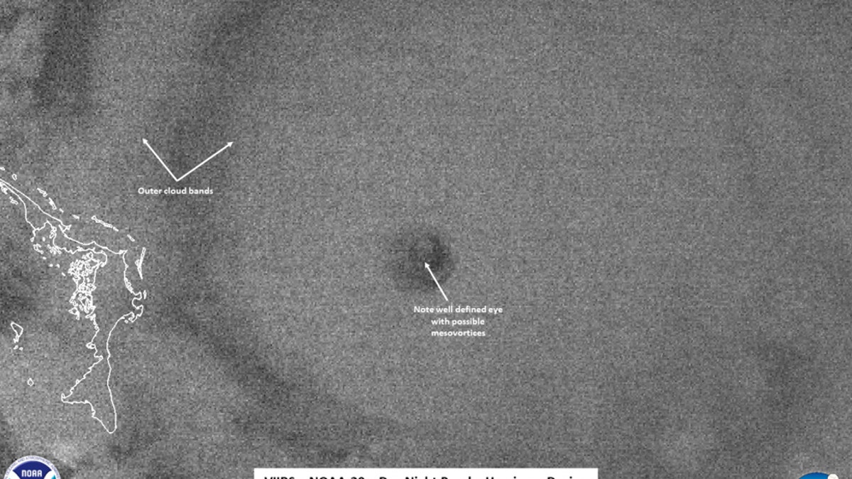
NOAA-20’s VIIRS instrument provides this image in its Day Night band of Hurricane Dorian at 2:30 am EDT on Sep. 01, 2019. (Credit: NASA/NOAA/UWM-SSEC-CIMSS/William Straka III)
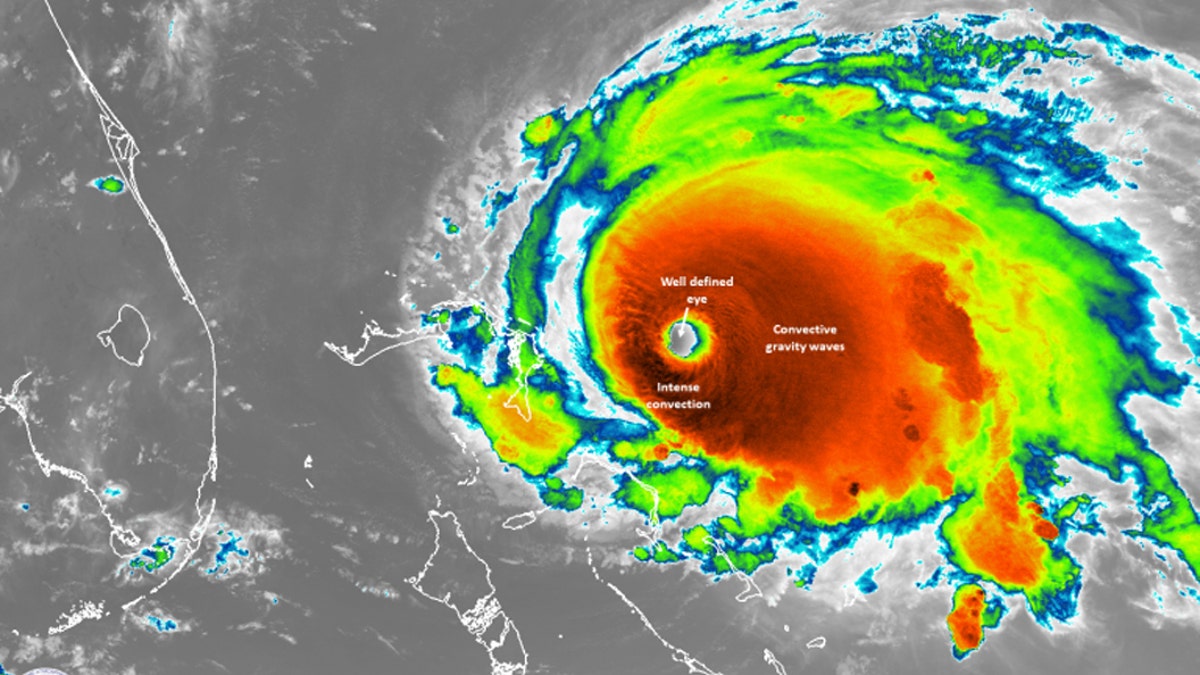
Suomi NPP image of Hurricane Dorian showing its well-defined eye as it passed over Dorian at 3:20 am EDT (0720 UTC). (NASA/NOAA/UWM-SSEC-CIMSS/William Straka III)
In a blog post, NASA said its Suomi NPP satellite caught the storm on the "east side of the scan in the Day Night band but due to the angle did not yield as many features due to noise at the edge of the scan, however, the well-defined eye can still be seen along with the tropospheric convective gravity waves flowing away from the storm."
The agency added that Dorian "is the fifth Category 5 hurricane sustained in the last five years."
NASA, which is tracking the storm throughout the long holiday weekend, said it will "provide status updates on the storm as it nears Florida and NASA’s Kennedy Space Center on the state’s central east coast, as well as updated video and imagery."
Last week, NASA said it was working to secure key launch infrastructure at Kennedy Space Center. “Our process right now is to protect our assets and infrastructure from potential damage, most notably being the Mobile Launcher, which will be located back inside the Vehicle Assembly Building for safekeeping,” NASA said in a video posted to social media on Thursday.
The Mobile Launcher is key to America’s space future. It'll be used to launch NASA’s Space Launch System rocket and Orion spacecraft from Kennedy Space Center’s Launch Pad 39B for future Artemis missions to the Moon.
In 2017, NASA said that Kennedy Space Center had sustained “a variety of damage” as a result of Hurricane Irma. A year earlier, the government agency reported limited damage to Kennedy Space Center from Hurricane Matthew.
Forecasters said Dorian was most likely to begin pulling away from the Bahamas early Tuesday and curving to the northeast parallel to the U.S. Southeast seaboard. Still, the potent storm was expected to stay close to shore and hammer the coast with dangerous winds and heavy surf, while authorities cautioned that it could still make landfall.
According to a Monday morning advisory from the U.S. National Hurricane Center in Miami, the storm was virtually parked over Grand Bahama island, which was in for a "prolonged period of catastrophic winds and storm surge" though the night. It also said Florida's east-central coast may see a brief tornado sometime between Monday afternoon and Monday night.
CLICK HERE TO GET THE FOX NEWS APP
The Associated Press and Fox News' James Rogers contributed to this report.