


With Tropical Storm Henri moving near the East Coast on Friday, officials are warning beachgoers about life-threatening conditions.
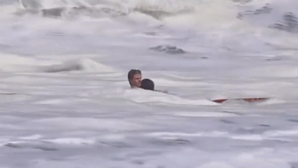
Rip currents and rough surf associated with the storm are already impacting coastlines this week and a father and son drowned in the waters near Oak Island, North Carolina on Wednesday.
FRED SLAMS NORTH CAROLINA, LEAVING 2 PEOPLE DEAD, 20 MISSING AFTER WIDESPREAD FLOODING
In Virginia, WAVY-TV reporters said Friday that the U.S. Coast Guard (USCG) Mid-Atlantic and other agencies were looking for a man they said went missing in the water at Gloucester Point Beach at around midnight.
"The Coast Guard’s search and rescue capabilities degrade as storm conditions strengthen, the USCG said in a statement. "This means help could be delayed."
"If you're headed to the beaches Friday and this weekend, please be advised that life-threatening surf and rips currents are expected during this time due to swells from tropical storm Henri," the National Weather Service (NWS) in Raleigh wrote on Facebook Wednesday.
The NWS advises beachgoers to check water conditions before entering, swim at beaches with lifeguards and do not make assumptions about the weather as "rip currents often form on calm, sunny days."
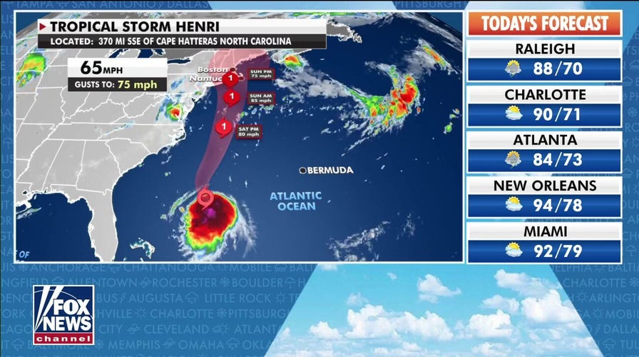
Henri was located a few hundred miles south-southeast of Cape Hatteras, North Carolina on Friday morning.
The National Hurricane Center said it had maximum sustained winds near 65 mph and tropical-storm-force winds extending outward up to 90 miles from its center.
Henri – which was tracked moving west-northwest near 9 mph and was forecast to turn northwest and north again later on Friday – is projected to shift near the Northeast on Sunday and Monday, approaching the coast of southern New England on Sunday.
The tropical storm is forecast to become a hurricane by Saturday – New England's first direct hit by a hurricane in 30 years – and hurricane conditions are possible within the hurricane watch area on Sunday.
Bracing for the storm, residents there began to haul boats from the water and take other precautions on Friday.
A Hurricane Watch is in effect for the South Shore of Long Island from Fire Island Inlet to Montauk, the North Shore of Long Island from Port Jefferson Harbor to Montauk, Nantucket, Martha's Vineyard, Block Island and New Haven, Connecticut to Sagamore Beach, Massachusetts.
2 DEAD, 1 RESCUED IN NORTH CAROLINA RIP TIDES
The Hurricane Center noted that the risks of storm surge, wind and rain impacts in southern New England and eastern Long Island are increasing.
A Storm Surge Watch is set for the South Shore of Long Island from East Rockaway Inlet to Montauk, the North Shore of Long Island from Kings Point to Montauk, Nantucket, Martha's Vineyard, Block Island and Kings Point, New York to Sagamore Beach, Massachusetts.
Tropical storm conditions are also possible on Sunday within the watch area including west of Fire Island Inlet to East Rockaway Inlet, New York, west of Port Jefferson Harbor, New York and west of New Haven, Connecticut.
The agency said that the combination of dangerous storm surge and the tide would lead to flooding inland from the shoreline in normally dry areas, with water reaching from 3 to 5 feet in areas from Watch Hill, Rhode Island to Sagamore Beach, Massachusetts should peak surge occur at the time of high tide.
The areas of East Rockaway Inselt to Montauk Point, the North Shore of Long Island and Kings Point, New York to Watch Hill, Rhode Island could see 2 to 4 feet and from New Jersey's Cape May to East Rockaway Inlet could get 1 to 3 feet.
Henri may produce rainfall of 2 to 5 inches over southern New England from Sunday into Monday, with isolated maximum totals near 8 inches.
CLICK HERE TO GET THE FOX NEWS APP
The Hurricane Center said heavy rainfall may result in flash, urban and small stream flooding.
Additional watches or warnings will be required later Friday and residents of the U.S. and Atlantic Canada are instructed to monitor the storm.
The Associated Press contributed to this report.