


Mandatory evacuations issued for the barrier islands of Florida for Hurricane Dorian
The Red Cross is stepping to provide aid in the wake of Hurricane Dorian; Jillian Mele reports.
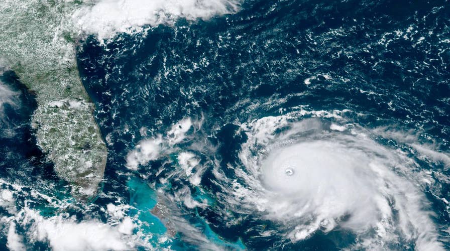
In the center of Hurricane Dorian, the eye of the storm reveals just how powerful it is.
The National Hurricane Center said in a 5 p.m. ET Sunday advisory that Dorian was a Category 5 storm with sustained winds of 185 mph and it was moving west at 5 mph, located about 95 miles east of Freeport on Grand Bahama Island in the Bahamas. The storm made landfall at 12:40 p.m. in Elbow Cay and is located about 175 miles east of West Palm Beach, Florida.
Air Force and reconnaissance planes from the National Oceanic and Atmospheric Administration -- known as the "hurricane hunters" -- have been crisscrossing the "distinct eye" of Dorian, and discovered the hurricane has become "extremely intense with a stadium effect in the eye," according to the NHC.
HURRICANE DORIAN, CATEGORY 5 STORM, BEARS DOWN ON BAHAMAS
"Here's a look at what scientists call the "stadium effect" inside the eye of #Dorian from @NOAA scientists," the NHC said on Twitter. "This happens at times in very strong hurricanes."
The "stadium effect" makes the hurricane eye look like a bowl of a sports stadium.
CONTINUING COVERAGE OF HURRICANE DORIAN ON FOX NEWS CHANNEL
The effect is caused by plumes of rapidly-rising air swirling into the storm and moving outwards from the core, causing the eye of the storm to become larger as the altitude above the ocean surface increases, according to the Washington Post.
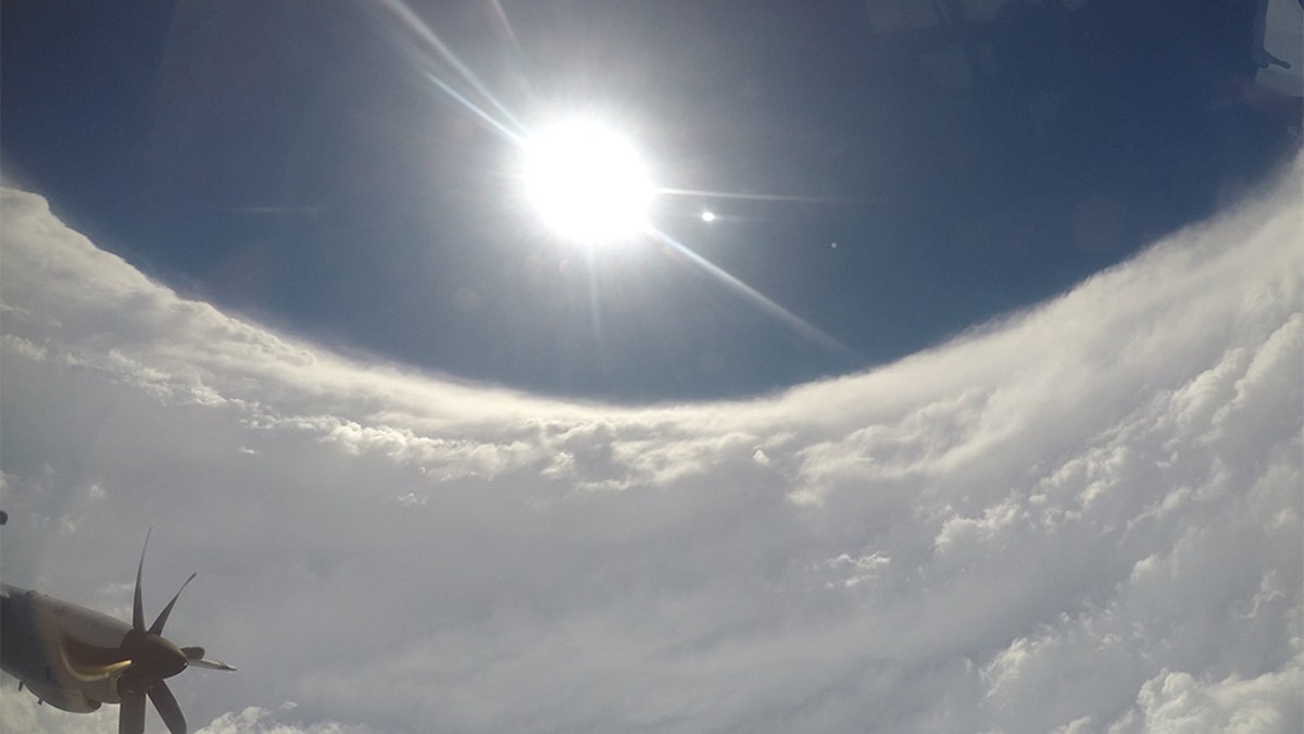
This image shows a clear view of the hurricane's "stadium effect." (U.S. Air Force photo by Garrett Black)
Meteorologist and hurricane hunter Garrett Black shared a photo Sunday afternoon on Twitter of the eye of Dorian with the "stadium effect" on full display.
A photo from a Hurricane Hunter P-3 Aircraft early Saturday also showed the towering eye of the storm as it was an extremely dangerous" Category 4 storm, bearing down on the northwestern Bahamas.

These photos provided by the National Hurricane Center shows views of Hurricane Dorian eye and the "stadium effect" in the center of the storm. (Paul Chang/National Hurricane Center)
OFFICIALS ISSUE STERN WARNINGS AS DORIAN NEARS U.S.: 'TAKE THIS STORM SERIOUSLY'
The Hurricane Hunters also shared photos on Twitter of the storm's eye at night, with some illuminated flashes from lightning inside.
Dorian is currently the strongest hurricane on record in the northwestern Bahamas and is forecast to bring "catastrophic winds and storm surge" to the Abaco Islands.
"Everyone there should take immediate shelter and not venture into the eye," the NHC said. "These catastrophic conditions are likely on Grand Bahama Island later today or tonight, and efforts to protect life and property there should be rushed to completion."
CLICK HERE FOR THE FOX NEWS APP
The Bahamas may experience hurricane conditions until Monday afternoon due to the slow-moving storm, which then is forecast to turn sharply and skirt up the U.S. coast, possibly staying just off Florida and Georgia on Tuesday and Wednesday and then affecting South Carolina and North Carolina on Thursday.
But forecasters warn that Dorian's path could easily shift and bring some of the worst conditions to coastal locations.
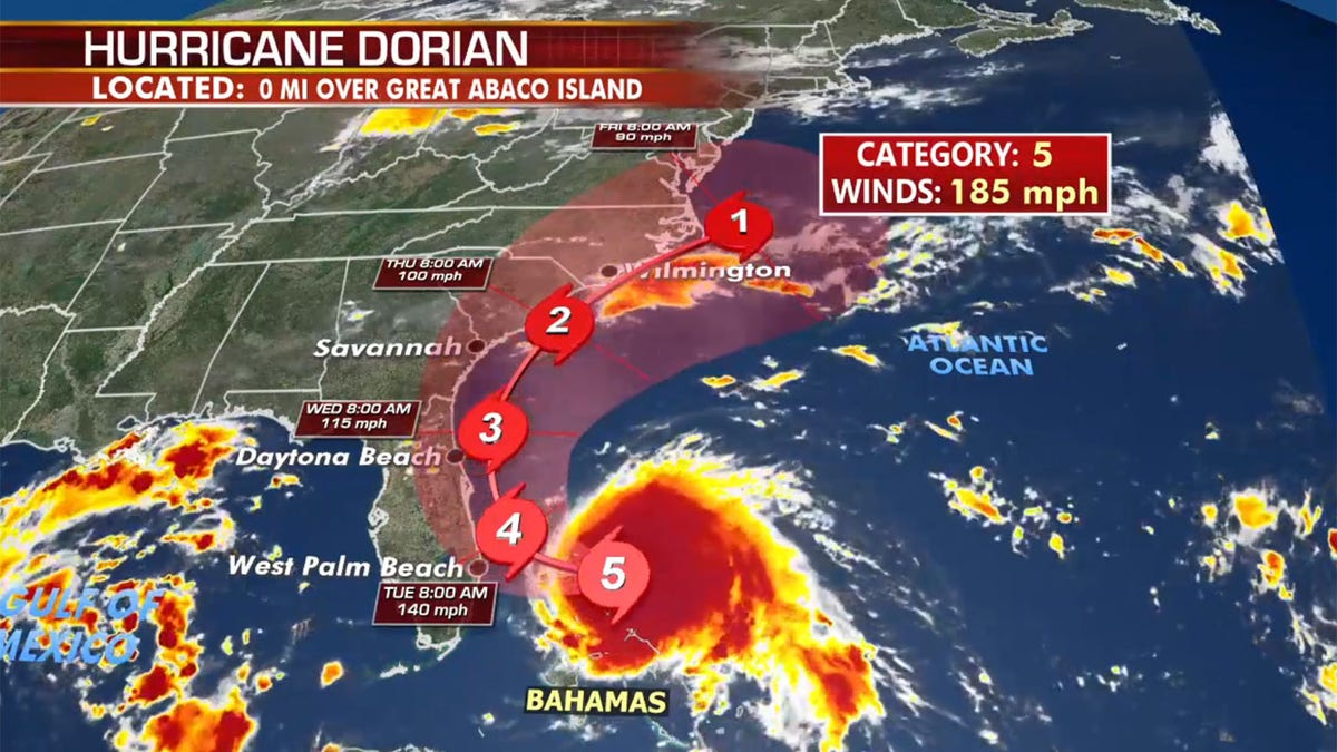
The forecast track of Hurricane Dorian. (Fox News)
"If there is a difference in the track by 30 miles, that's the difference between tropical-storm-force and hurricane winds," Fox News Senior Meteorologist Janice Dean said Sunday on "Fox & Friends." That's why we have to wait for every forecast."