


This Halloween, the forecast is rather frightful.
A storm system with an associated cold front will continue moving east on Thursday, bringing wet weather for trick-or-treaters from the Gulf Coast to the Northeast -- even some snow to the Midwest, according to forecasters.
The National Weather Service's Weather Prediction Center said that above-normal temperatures in the East combined with a mighty cold front are creating a "huge contrast in temperature," setting up the stage for a messy Halloween.
"We could potentially see some severe storms from the Mid-Atlantic up towards the Northeast, so that could cause some big problems," Fox News Senior Meteorologist Janice Dean said on "Fox & Friends." "If your Halloween plans are delayed, it's for a good reason. We could see some strong storms and some heavy rain."
‘EXTREME RED FLAG WARNING' IN SOUTHERN CALIFORNIA: WHAT TO KNOW
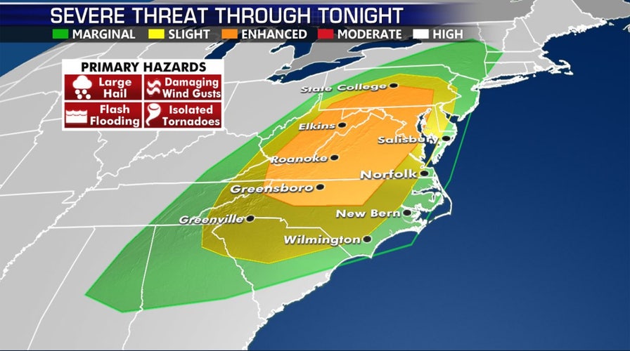
The "vigorous dynamics" ahead of the cold front are likely to bring a round of severe thunderstorms across the Appalachians followed by the Mid-Atlantic later in the day, according to the WPC.

There is an enhanced threat of severe weather across the Mid-Atlantic on Halloween, according to forecasters. (Fox News)
"It's going to be a wet one across the Eastern Seaboard," Dean said Thursday. "Unfortunately, this is going to cause some problems for trick-or-treaters."
The NWS also warned that some severe thunderstorms could be strong enough to produce "perhaps a few tornadoes" across the region.
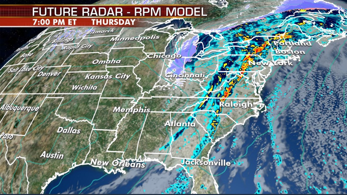
A squall line is forecast to develop as a cold front moves east, potentially impacting trick-or-treaters on Halloween. (Fox News)
A squall line is expected to develop ahead of a cold front Thursday afternoon, with damaging wind gusts becoming the primary threat from these storms, in addition to the threat of localized flash flooding. Besides the severe weather, additional impacts are expected.
"Widespread rainfall is expected to greet Trick-or-Treaters from the Deep South to much of the East Coast as the low-pressure system intensifies rapidly and heads toward the Great Lakes today and into New England on Friday," the NWS said.
HALLOWEEN FORECAST LOOKS TO BE WET, STORMY IN EAST AS SIGNIFICANT SNOW TO IMPACT PLAINS INTO MIDWEST
The concerns about the upcoming storm have caused numerous communities to move trick-or-treating to a different date. In West Virginia, officials have moved trick-or-treating from Thursday to Saturday in Charleston and Huntington.
Several towns in Massachusetts and New Hampshire also postponed Halloween trick-or-treating until the weekend, when weather conditions are forecast to improve, Boston 25 reported.

The Halloween forecast across the U.S. (Fox News)
Manuta Township in New Jersey moved up trick-or-treating to Wednesday after consulting with the local police department.
“The safety of children is our #1 priority,” the township told FOX29.
The storms are coming ahead of an arctic blast that forecasters say could bring record cold to the South.
Temperatures were predicted to drop as much as 30 degrees in a few hours on Thursday as the arctic blast arrived. Winds were gusting above 30 mph in some areas, but no damage was reported immediately. A freeze warning reached across more than a dozen states, from southwestern Texas into the South and Midwest.
The arctic weather was bringing accumulating wet snow across Midwest and into the Great Lakes by Thursday night.
CLICK HERE FOR THE FOX NEWS APP
The storms provided another round of drought relief across the Southeast after weeks of dry weather endangered crops and increased fire risks. But a new federal report showed much of Alabama, Georgia and South Carolina are still too dry.
The Associated Press contributed to this report.