


National forecast for Wednesday, July 8
Fox News senior meteorologist Janice Dean has your FoxCast.
Another day of hot temperatures across the nation's midsection on Wednesday will fuel the threat of severe weather.
Strong to severe thunderstorms will be possible throughout the day along with a cold front that's moving through the Midwest.
Large hail, damaging winds, and isolated tornadoes will be possible, along with the risk of flash flooding where pockets of heavy rain accumulate.
NYC SEES STUNNING LIGHTNING FROM THUNDERSTORMS, FLASH FLOODS IN NORTHEAST AMID STORMY WEEK
The greatest risk of severe weather is from parts of Kansas across Nebraska into northwest Iowa, Minnesota, and northern Wisconsin.

The greatest risk of severe weather on Tuesday. (Fox News)
Ahead of the cold front fueling the storms, temperatures are hot with humidity, allowing heat indices (feels like) temperatures to rise into the 90-100 degree range.
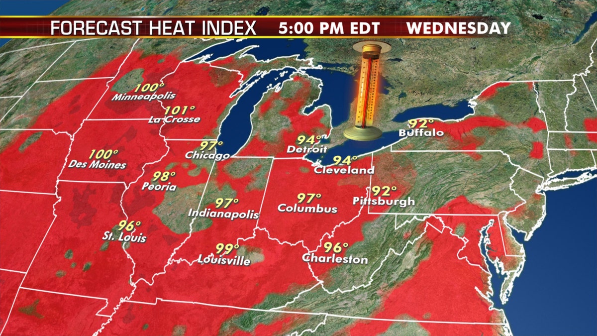
The forecast heat index for Wednesday across the Midwest. (Fox News)
Heat advisories are in effect across the Midwest and Great Lakes on Wednesday.

Heat advisories stretch across the Midwest into the Great Lakes on Wednesday. (Fox News)
Temperatures will drop several degrees Thursday, especially across the Upper Midwest.
HOT WEATHER CAUSING DOZENS OF ROADS TO BUCKLE IN ILLINOIS, WISCONSIN
This system fueling the severe storms will move into the Great Lakes by Thursday.

The national forecast for July 8, 2020.
In terms of other precipitation on Wednesday, a stalled front along with an area of low pressure will bring scattered showers and thunderstorms stretching from Texas into the Southeast.
Wildfire threat continues out West

Fire danger lingers out West on Wednesday, July 8, 2020. (Fox News)
Fire danger remains high on Wednesday over parts of the Interior West and the Rockies with ongoing breezy conditions and low humidity.
CLICK HERE FOR THE FOX NEWS APP
Red flag warnings are in effect for portions of Arizona, Utah, Colorado, and Wyoming.

True Crime
The hottest stories ripped from the headlines, from crime to courts, legal and scandal.
By entering your email and clicking the Subscribe button, you agree to the Fox News Privacy Policy and Terms of Use, and agree to receive content and promotional communications from Fox News. You understand that you can opt-out at any time.
