


New Orleans bracing for another possible foot of rain as Gulf system grows stronger
Louisiana is under a state of emergency with fears that an approaching system could reach hurricane level after severe storms trigger widespread flash flooding; Casey Stegall reports from the scene.
A brewing tropical weather system in the Gulf of Mexico forced mandatory evacuations in parts of Louisiana on Thursday, as a potential hurricane is expected to spark flash flooding in places like New Orleans still drying out from torrential rain.
The National Hurricane Center said Tropical Storm Barry is located about 95 miles south-southeast of the mouth of the Mississippi River is expected to strengthen into a hurricane by late Friday and make landfall by early Saturday along the Louisiana coast. Barry is the second named storm of the Atlantic hurricane season.
"This is crawling across the Gulf of Mexico, which means there is still a little bit of time for this to change and it also means the longer it moves, the slower it moves, the longer the rain can pile up," Fox News Meteorologist Adam Klotz said Thursday on "FOX & friends."
NEW ORLEANS, GULF COAST FACE FLOODING THREAT FROM LIKELY TROPICAL STORM BARRY
As of 11 a.m. Thursday, the system had sustained winds of 40 mph and was moving west at 5 mph. A hurricane watch was in effect for the Louisiana coast from the mouth of the Mississippi River to Cameron, La., while a tropical storm warning stretched along the coast from the mouth of the Pearl River to Morgan City.
An additional tropical storm watch was in effect for the Mississippi coast east of the mouth h of the Pearl River to the Mississippi/Alabama border in addition to Lake Pontchartrain and Lake Maurepas, including metropolitan New Orleans.

Tropical Storm Barry is forecast to be a hurricane by Friday night. (Fox News)
"The system is expected to produce total additional rain accumulations of 10 to 15 inches near and inland of the central Gulf Coast through early next week, with isolated maximum rainfall amounts of 20 inches," the NHC said. "Rainfall amounts exceeding 6 to 9 inches have already occurred across portions of the New Orleans metropolitan area, which has resulted in flooding."
Klotz said Thursday that just the initial rain bands from the system created major flooding across the New Orleans area.
"There's going to be a lot more rain before all is said and done," he added.
National forecast for Thursday, July 11
Adam Klotz has your FoxCast.
Louisiana Gov. John Bel Edwards declared a state of emergency Wednesday and said National Guard troops and high-water vehicles will be positioned all over the state.
"The entire coast of Louisiana is at play in this storm," he warned.
NEW ORLEANS, ALREADY GRAPPLING WITH EXTREME WEATHER, MAY FACE HURRICANE BY WEEK'S END
On Wednesday, New Orleans got an early taste of what may be in store in the days ahead, as torrential rains paralyzed rush-hour traffic and stalled cars around the city. New Orleans Mayor LaToya Cantrell said Thursday the city's water pumps are "working at optimal capacity," but that flooding is a threat because slow-moving, heavy rains are expected from the storm.
"We cannot pump our way out of the water levels expected in New Orleans," Cantrell said.
Mandatory evacuation orders were issued for parts of Plaquemines Parish starting at 6 a.m. Thursday, FOX8 reported.

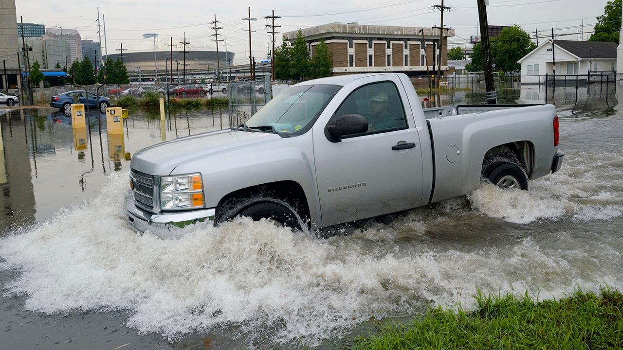
Frank Conforto Jr. walks in the parking lot of the University Medical Center (UMC) with the Mercedes-Benz Superdome in the background on Glavez Street in New Orleans after flooding from a storm Wednesday, July 10, 2019. (AP Photo/Matthew Hinton)
Plaquemines Parish President Kirk Lepine said the order was issued as a cautionary measure in response to the historically high water levels being recorded in the Mississippi River. Similar evacuations were ordered in Jefferson Parish.
“We’ve never experienced a high river like this before in such an early period of the hurricane season. The unknown is what’s got us to a little concerned," Lepine told FOX8. "We want the public to heed to our warnings. If we asked you to evacuate, if we ask you to move, please find a way."

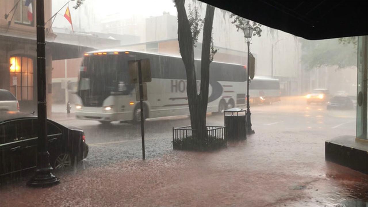
An NOPD cruiser blocks the underpass at S. Carrollton Ave. in New Orleans as severe thunderstorms caused street flooding, Wednesday, July 10, 2019. (Max Becherer/The Advocate via AP)
Up to 10,000 people are affected by the evacuation orders in Plaquemines Parish, according to Nola.com.
A mandatory evacuation was also issued for Grand Isle beginning at noon on Thursday.
"If anyone has vehicles, boats, or campers in low areas they should bring them to higher areas until this storm has passed," Mayor David Camardelle said in a statement. "All of our pumps are up and running and we also have back up pumps with Jefferson Parish on standby."
HERE ARE THE DEADLIEST AND COSTLIEST HURRICANES TO HIT THE US MAINLAND
A spokesman for the Army Corps of Engineers in New Orleans said the agency was not expecting widespread overtopping of the levees, but there are concerns for areas south of the city. The weather service expects the river to rise to 20 feet by Saturday morning at a key gauge in the New Orleans area, which is protected by levees 20 to 25 feet high.

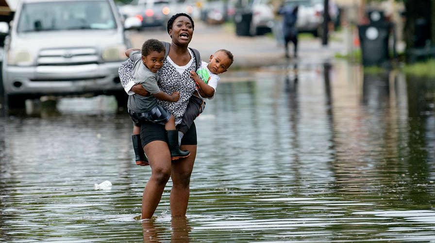
Jalana Furlough carries her son Drew Furlough as Terrian Jones carries Chance Furlough on Belfast Street near Eagle Street in New Orleans after flooding from a tropical wave system in the Gulf Mexico that dumped lots of rain in Wednesday, July 10, 2019. (AP Photo/Matthew Hinton)
The Corps was working with local officials down river to identify any low-lying areas and reinforce them, spokesman Ricky Boyett told the Associated Press. He cautioned that the situation may change as more information arrives.
"We're confident the levees themselves are in good shape. The big focus is height," Boyett said.
New Orleans officials have asked residents to keep at least three days of supplies on hand and to keep their neighborhood storm drains clear so water can move quickly.
CLICK HERE FOR THE FOX NEWS APP
Louisiana declares state of emergency ahead of possible tropical storm
The Gulf Coast gets a preview of a potentially-major story headed its way as it forms in the Gulf of Mexico.
As the water from Wednesday morning's storms receded, people worried about what might come next.
"This is going to be a slow storm...That's what I'm concerned about," Tanya Gulliver-Garcia told the AP.
The Associated Press contributed to this report.