


Fox News Flash top headlines for September 10
Fox News Flash top headlines are here. Check out what's clicking on Foxnews.com.
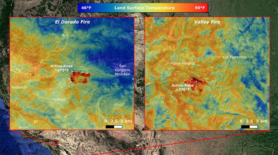
NASA has measured California wildfire temperatures using an instrument on the International Space Station.
The space agency’s ECOsystem Spaceborne Thermal Radiometer Experiment on Space Station (ECOSTRESS) imaged the fires, including the El Dorado fire near Yucaipa and the Valley Fire in Japatul Valley, according to NASA.
CALIFORNIA AND OREGON WILDFIRES SPOTTED FROM SPACE IN INCREDIBLE SATELLITE PICTURES
The images were captured on Sept. 6.

NASA’s ECOsystem Spaceborne Thermal Radiometer Experiment on Space Station (ECOSTRESS) imaged active fires across California on Sept. 6, 2020. (Image Credit: NASA/JPL-Caltech)
“Both images, taken at 12:13 a.m. PDT (3:13 a.m. EDT), show multiple concentrated areas of surface temperatures (in red) higher than 375 degrees Fahrenheit (191 degrees Celsius),” NASA said, in a statement. “These high-temperature regions were likely where the active fires were occurring. The surrounding areas show abnormally warm middle-of-the-night background surface temperatures (orange) due to the ongoing heat wave.”
ECOSTRESS is operated by NASA’s Jet Propulsion Laboratory.
DEVASTATING WILDFIRE 'ANATOMY' EXPLAINED
The California and Oregon wildfires have also been spotted from space in remarkable satellite pictures. The images, captured by National Oceanic and Atmospheric Administration (NOAA) and NASA satellites, show the incredible scale of the wildfires.
CLICK HERE TO GET THE FOX NEWS APP
At least seven people have died from the wildfires ravaging the West Coast.
Fox News’ Travis Fedschun contributed to this article.
Follow James Rogers on Twitter @jamesjrogers