


Declassified U2 spy plane images reveal ancient sites
Declassified Cold War-era images from U2 spy planes have been digitally scanned and analyzed by researchers from the University of Pennsylvania and Harvard, revealing ancient structures across the Middle East. The images are of particular importance given the conflicts ravaging parts of the region in recent years. The U2 images are of a higher resolution than any satellite photos previously used to study the area during that time.
Experts from the University of Pennsylvania and Harvard have scanned declassified Cold War-era images from U2 spy planes to reveal ancient structures across the Middle East.
Emily Hammer, assistant professor of near eastern languages and civilizations at the University of Pennsylvania and Jason Ur, professor of anthropology at Harvard, painstakingly analyzed thousands of once-secret aerial photos from the 50s and 60s.
The images, for example, reveal “desert kites,” which are ancient stone wall structures used to trap animals such as gazelle. An Assyrian canal system in northern Iraq was also spotted in the images, providing a glimpse into the ancient empire’s government and transport network.
SPY SATELLITES, DRONES, HELP EXPERTS DISCOVER LOST CITY IN IRAQ FOUNDED AFTER ALEXANDER THE GREAT
The research is published in the journal Advances in Archaeological Practice.
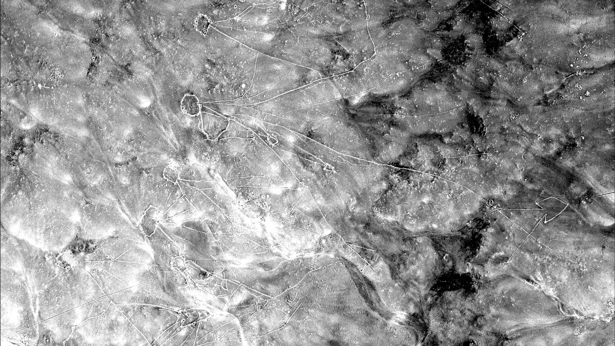
Chains of "desert kites" visible in U2 imagery captured on Jan. 30, 1960. (Emily Hammer and Jason Ur)
Hammer told Fox News that the research is particularly important given the conflicts that have ravaged parts of the region in recent years. “These archival images would be important regardless of the current geopolitical moment, but they take on additional historical significance given the enormous amount of cultural heritage destruction in the Middle East in the last decade, following the Arab Spring,” she explained, via email. “The Islamic State deliberately demolished and heavily looted many important archaeological and historical sites in Syria and Iraq like Apamea, Hatra, and Nimrud.”
Additionally, fighting between various factions has totally destroyed whole neighborhoods of historically important cities like Aleppo and Mosul, according to Hammer. “The U2 photos have become invaluable cultural documents because they show these places before the massive recent destruction,” she said.
MYSTERIOUS 4,000-YEAR-OLD LOST CITY DISCOVERED
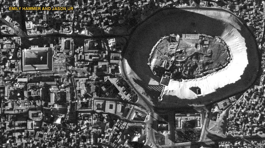
One image captured by a U2 spy plane in 1959, for example, shows the famous citadel of Aleppo. A UNESCO World Heritage site, the citadel was damaged in 2015 during fierce fighting in the city between Syrian government forces and rebels opposed to the regime of President Bashar al-Assad.
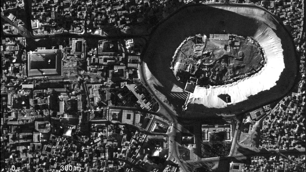
A high-resolution U2 photograph of the citadel in Aleppo, Syria, taken Nov. 19, 1959. (Emily Hammer and Jason Ur)
Hammer explained that the spy plane pictures also serve as an important cultural document of southern Iraq’s Marsh Arabs, who were brutally repressed by Saddam Hussein. “I was shocked that you could see small individual reed houses and floating reed islands in the 1958 and 1960 marsh villages in southern Iraq,” she said. “People lived a unique lifestyle in the marshes of southern Iraq for thousands of years—herding water buffalo, building houses and all manner of things out of reeds, living on floating islands of reeds, planting date palms, and fishing. This lifestyle has disappeared since the deliberate draining of the marshes by Saddam Hussein and the reduction of water flow by hydroelectric dams. It has also been affected by modern ideas about marshes as ‘wasteful’ and undesirable areas.”
In another study, Hammer used U2 imagery to map many of the rivers and canals surrounding the ancient city of Ur in southern Iraq. “The Euphrates river has moved a lot through time, and is now today about 15 km [9.3 miles] away, abandoning the site in the middle of the desert,” she said. “But in ancient times various channels of the Euphrates flowed next to the city. Because of the U2 imagery, we can now work to date those ancient rivers and canals and we can work to figure out whether early southern Mesopotamian cities like Ur emerged in an irrigated plain or in a marsh-like environment.”
LOST CITY MYSTERY SOLVED AS ARCHAEOLOGISTS DECIPHER ANCIENT CLAY TABLETS
Previously, archaeologists had relied on images from the CORONA U.S. spy satellite program, which ran from 1959 to 1972. However, only the highest-resolution images from the final 5 years of the program were archaeologically useful, according to the University of Pennsylvania and Harvard researchers. In contrast, the U2 images are higher resolution than even the sharpest CORONA pictures.
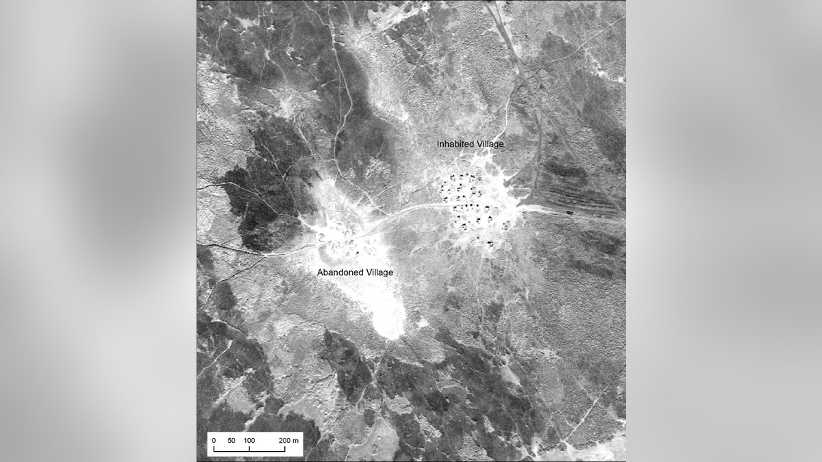
An inhabited Marsh Arab village and adjacent abandoned village in southern Iraq, photographed during a U2 mission in January 1960. (Emily Hammer and Jason Ur)
Aerial imagery can provide vital clues to archaeologists. In a separate project, for example, experts harnessed spy satellite imagery and drones to help identify the site of an ancient lost city in Northern Iraq.
The Qalatga Darband site overlooks the Lower Zab river at the western edge of the Zagros Mountains, and is part of a historic route from ancient Mesopotamia to Iran.
EXPERTS HARNESS 3D PRINTING TO RECREATE ANCIENT ARTIFACTS DESTROYED BY ISIS
Left: A U2 image of Ur (Tell al-Muqayyar), Iraq, captured on Oct. 30, 1959. Right: a CORONA satellite image of the same site captured on May 4, 1968. (Emily Hammer and Jason Ur)
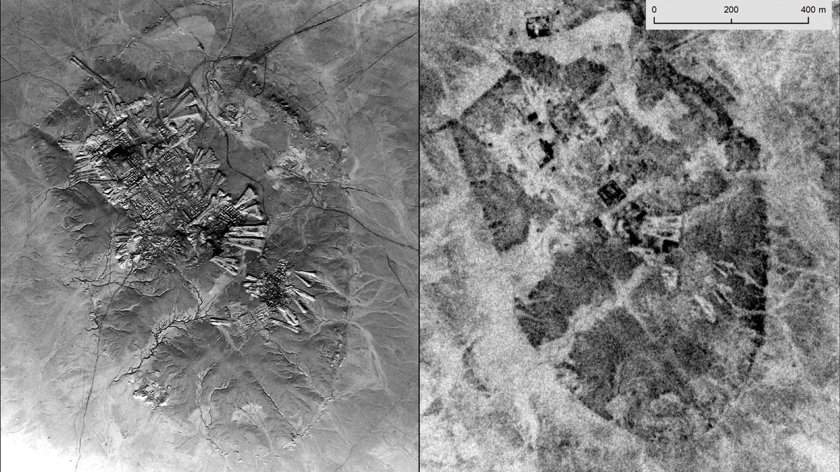
Technology is an important tool for archaeological research. In 2018, archaeologists in western Mexico used sophisticated laser technology to discover a lost city that may have had as many buildings as Manhattan.
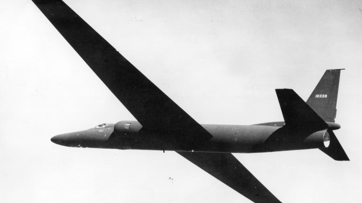
File photo of a U2 spy plane. (Hulton Archive/Getty)
CLICK HERE TO GET THE FOX NEWS APP
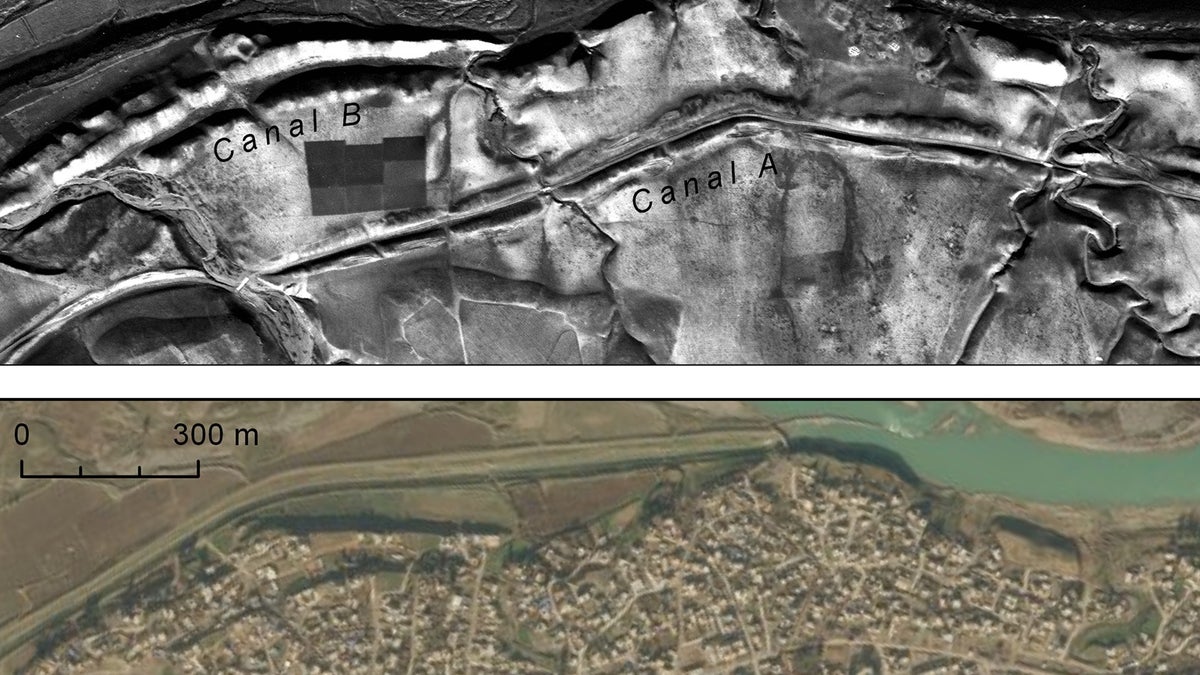
At top, canals and site on the right bank of the Upper Zab River, photographed by a U2 spy plane on Jan. 20, 1960. At bottom, DigitalGlobe image showing the growth of the modern town of Khabat over the same features. (Emily Hammer and Jason Ur)
Experts recently created a stunning digital reconstruction of a centuries-old lost city discovered in South Africa. In another project, researchers have shed new light on the events that led to the demise of the ancient Cambodian megacity of Angkor.
Follow James Rogers on Twitter @jamesjrogers