


As August comes to a close, all eyes are on the tropics during what has already been an abnormally active hurricane season while forecasters monitor four disturbances on Monday, including two that are now likely to develop.
The U.S. National Hurricane Center (NHC) in Miami said that two systems in the western part of the Atlantic basin are "likely" to become tropical depressions "during the next few days."
Historically, September produces the most Atlantic Ocean basin tropical activity.
ATLANTIC HURRICANE SEASON: WHERE DO TROPICAL STORMS FORM IN AUGUST?
Currently, several tropical waves and low-pressure systems have a chance to become our next named storm, including two determined "likely" by the NHC.
Several hundred miles off the coast of Jacksonville, Fla., a low-pressure system is becoming better organized and is expected to become a tropical depression by midweek.
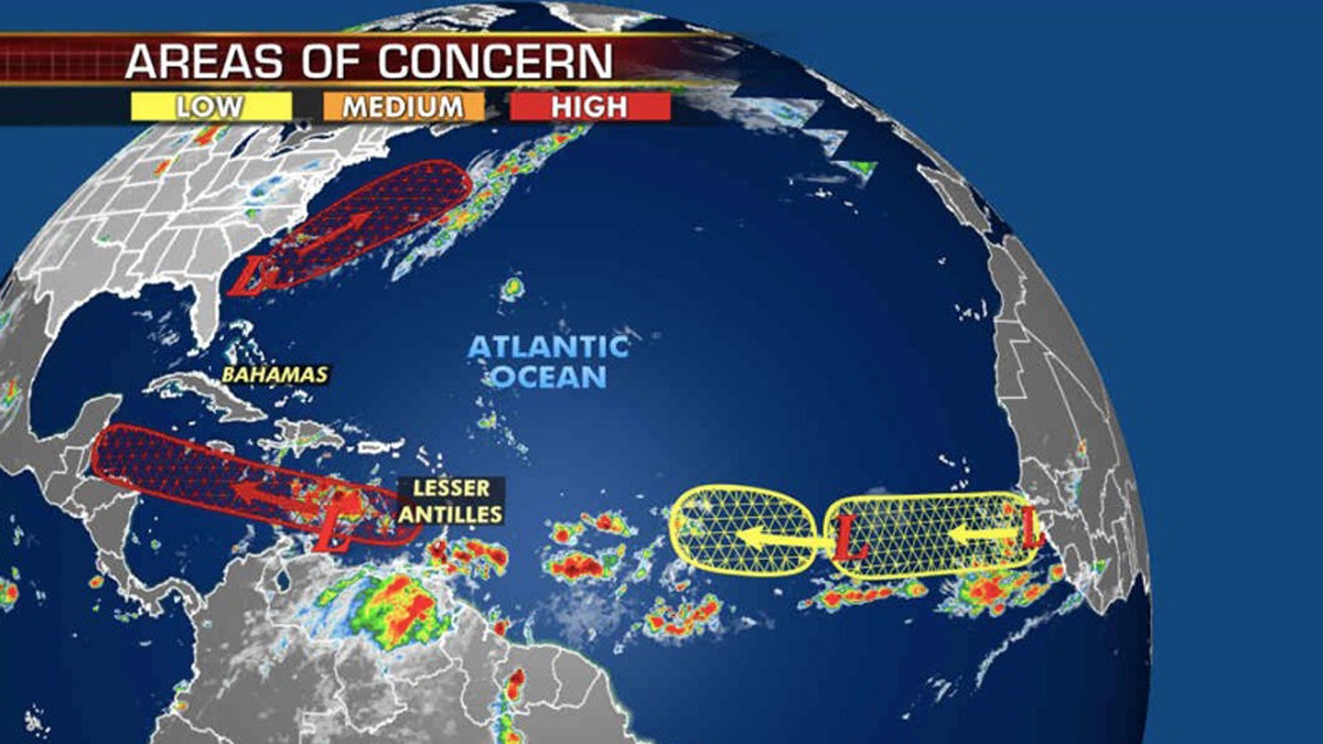
Two systems are "likely" to develop into tropical depressions in the next few days, according to the National Hurricane Center. (Fox News)
The NHC said Monday morning that there's a 70% chance this system develops over the next 48 hours. An Air Force Reserve Hurricane Hunter aircraft is scheduled to investigate the system by Monday afternoon if necessary.
However, upper-level winds are expected to move this system away from land, heading northeastward out over the ocean.
Meanwhile, another area of low pressure in the Caribbean just north of Venezuela is expected to become a tropical depression in the next few days. The NHC said there's an 80% chance this system develops over the next five days as it moves westward over the Caribbean Sea at around 15 to 20 mph.
While not an immediate threat to the U.S., this system will need to be monitored as it approaches.
2020 ATLANTIC HURRICANE SEASON NAMES: HERE'S THE FULL LIST FROM ARTHUR TO WILFRED
"Interests in Jamaica, Honduras, Belize, Guatemala, and the Yucatan peninsula should monitor the progress of this disturbance," the NHC said.

Two other tropical waves present development opportunities over the eastern Atlantic over the next couple of days but are only at 30% and 10% through the next five days, according to the NHC.
If the two areas with a high chance of formation develop, they could set more records for the busy 2020 Atlantic hurricane season. The next two names on the 2020 Atlantic hurricane season list are Nana and Omar.
CLICK HERE FOR MORE WEATHER COVERAGE FROM FOX NEWS
According to Colorado State University hurricane research scientist Philip Klotzbach, the current earliest record for the 14th and 15th named storm dates are Nate, which formed on Sept. 6, 2005, and Ophelia, which formed on Sept. 7, 2005.
The recent activity comes as the hurricane season has entered the most active portion. The historical hurricane activity climbs through August until Sept. 10, where it peaks and starts to slowly go back down.
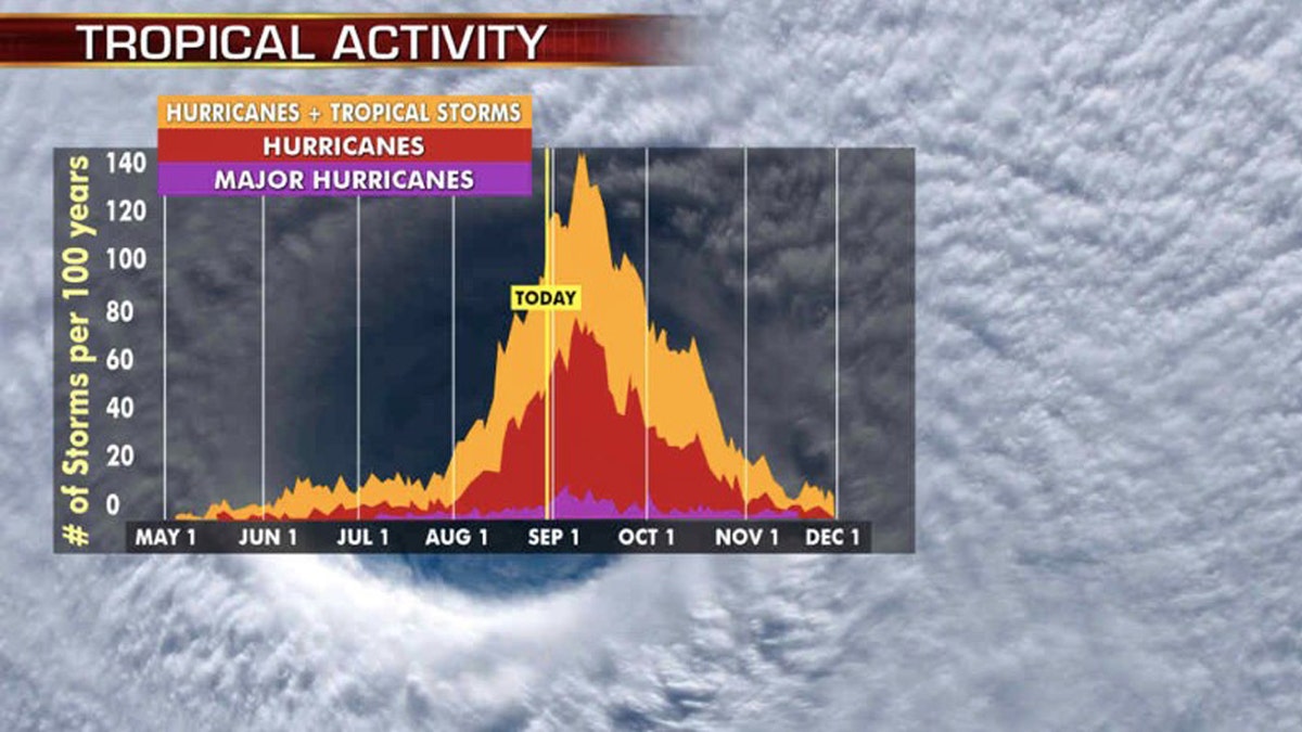
The historic peak of hurricane season is September 10th. (Fox News)
Historically, about two-thirds of all Atlantic hurricane activity happens between Aug. 20 to Oct. 10, Klotzbach tweeted earlier this month.
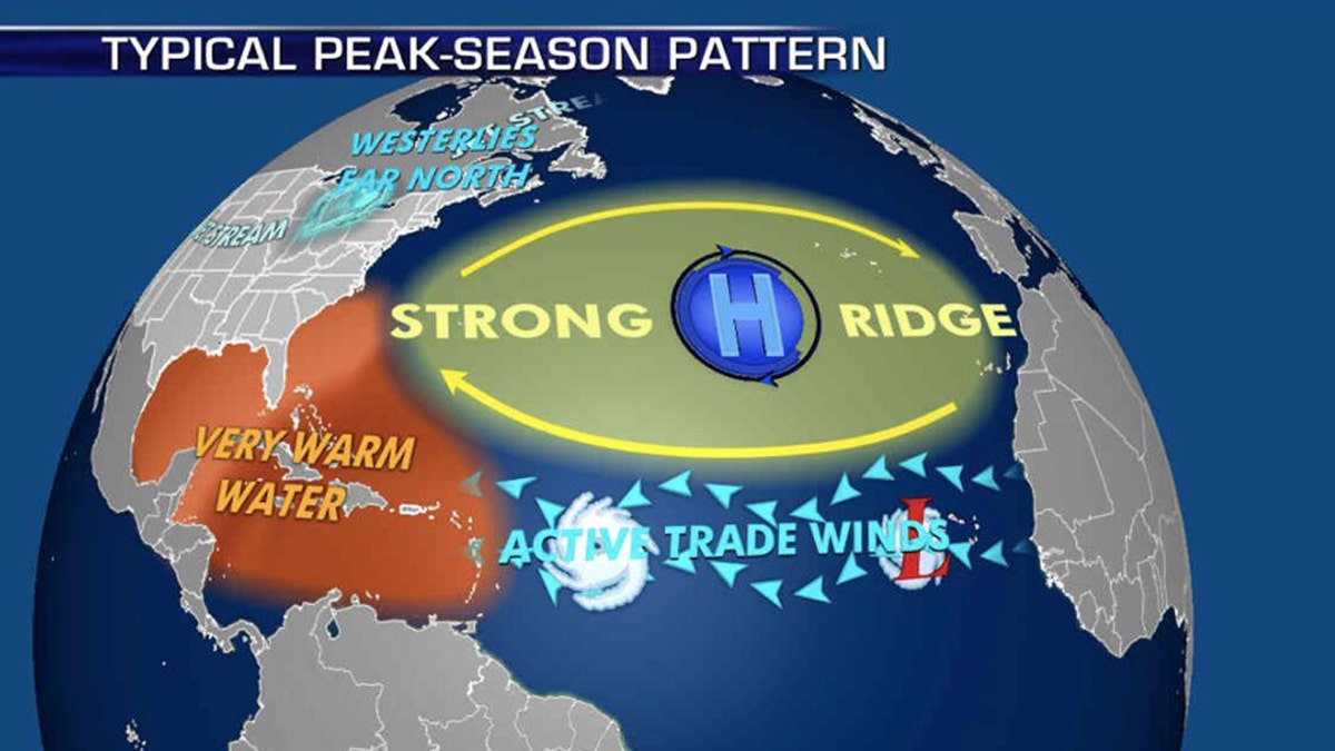
The patterns during the peak of hurricane season that influence where storms travel. (Fox News)
NOAA forecasters are now calling for up to 25 named storms with winds of 39 mph or higher; of those, seven to 10 could become hurricanes. Among those hurricanes, three to six will be major, classified as Category 3, 4 and 5 with winds of 111 mph or higher.
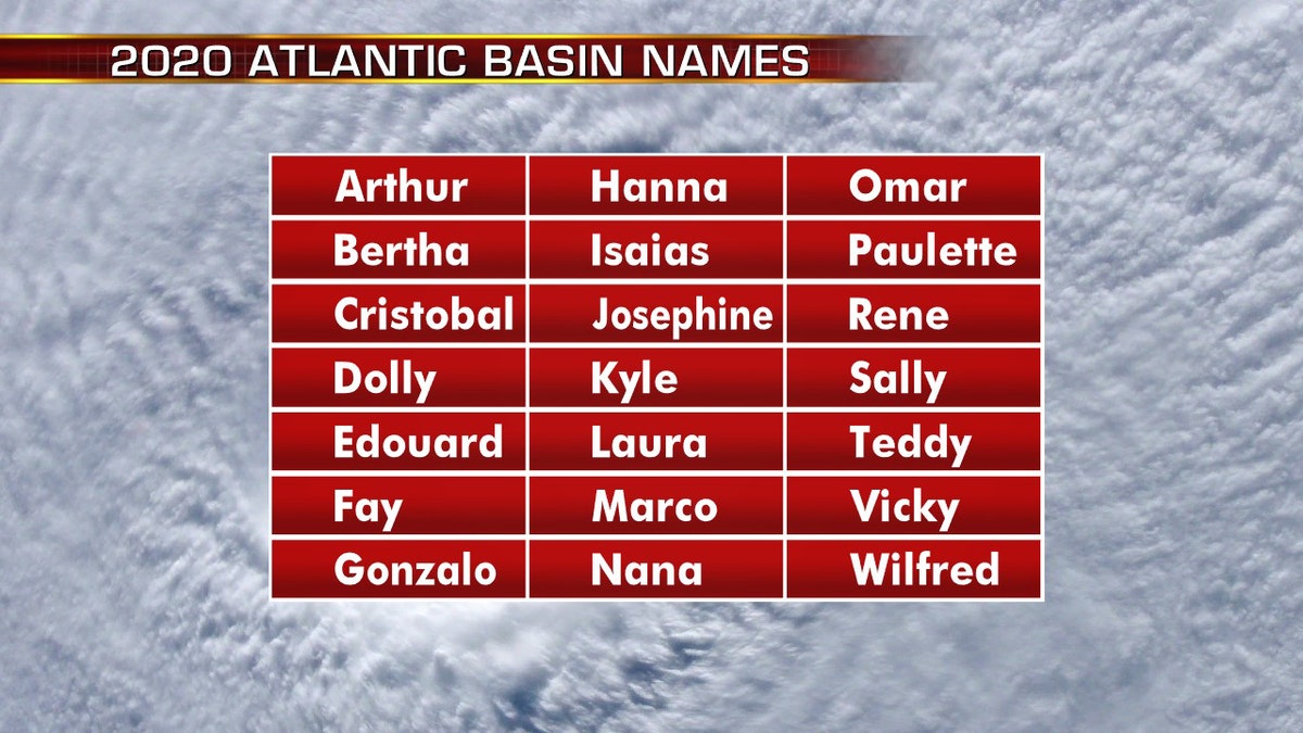
The names for the 2020 Atlantic hurricane season. (Fox News)
That's far above an average year. Based on 1981 to 2010 data, that is 12 named storms, six hurricanes and three major hurricanes. So far this year, there have been 13 named storms, including three hurricanes.
CLICK HERE FOR THE FOX NEWS APP
The 2020 Atlantic Hurricane Season runs from June 1 to Nov. 30 and includes the names: Arthur, Bertha, Cristobal, Dolly, Edouard, Fay, Gonzalo, Hanna, Isaias, Josephine, Kyle, Laura, Marco, Nana, Omar, Paulette, Rene, Sally, Teddy, Vicky and Wilfred.
Fox News' Brandon Noriega contributed to this report.

True Crime
The hottest stories ripped from the headlines, from crime to courts, legal and scandal.
By entering your email and clicking the Subscribe button, you agree to the Fox News Privacy Policy and Terms of Use, and agree to receive content and promotional communications from Fox News. You understand that you can opt-out at any time.
