


The third hurricane of the Atlantic hurricane season continues to strengthen at sea Tuesday, bringing the threat of high winds and heavy rain to Bermuda in addition to potentially deadly rip currents to the Southeast coast.
The National Hurricane Center in Miami said Hurricane Humberto is located about 525 miles west of Bermuda with maximum sustained winds of 100 mph and is moving east-northeast at 8 mph. The hurricane is now a Category 2 storm.
"Data from the Hurricane Hunters aircraft indicate that maximum sustained winds have increased to near 100 mph with higher gusts," the NHC said. "Additional strengthening is forecast during the next 36 hours, and Humberto is expected to become a major hurricane by tonight or Wednesday morning."
HUMBERTO STRENGTHENS INTO HURRICANE, MAY BRING HEAVY RAIN TO BERMUDA
A "major hurricane" is defined as having winds above 111 mph, according to the Saffir-Simpson Hurricane Wind Scale. Category 3, Category 4 and Category 5 storms are all labeled “major” hurricanes.
Humberto is expected to continue moving east-northeast through Thursday, with a gradual increase in forward speed.
"On the forecast track, the center of Humberto is expected to pass just to the north of Bermuda Wednesday night.," the NHC said.
Bermuda's weather service has issued a hurricane watch and tropical storm warning for the island, which means that tropical storm conditions are expected within the next 36 hours. Hurricane-force winds extend outward up to 60 miles from the center of the storm, while tropical-storm-force winds extend outward up to 150 miles.
Humberto is forecast to bring tropical-storm-force winds by late Wednesday, in addition to two to four inches of heavy rain with isolated eight-inch amounts. Hurricane conditions are possible over Bermuda Wednesday night into Thursday morning.
Large swells generated by Humberto are expected to increase along Bermuda's coast by Wednesday.
While the storm is not threatening the U.S. mainland, it's still creating some dangers for beachgoers. Large swells are forecast to affect the Southeast coast from east-central Florida to North Carolina over the next couple of days.
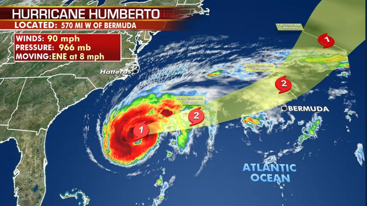
The forecast track of Hurricane Humberto. (Fox News)
"These swells could cause life-threatening surf and rip current conditions," the NHC said.
Humberto is the eighth named storm and third hurricane of the 2019 Atlantic hurricane season.
The National Oceanic and Atmospheric Administration has said it expects 10-17 named storms this hurricane season, with winds of 39 mph or higher, of which five to nine could strengthen into hurricanes. Of those storms, there will be two to four major hurricanes.
CLICK HERE FOR THE FOX NEWS APP
The 2019 Atlantic Hurricane Season runs from June 1 to Nov. 30, and this year includes the names: Andrea, Barry, Chantal, Dorian, Erin, Fernand, Gabrielle, Humberto, Imelda, Jerry, Karen, Lorenzo, Melissa, Nestor, Olga, Pablo, Rebekah, Sebastien, Tanya, Van, and Wendy.