2019 Atlantic Hurricane season expected to pack some punch
The United States may get hit by two to four major hurricanes before the end of the 2019 hurricane season. Forecasters are calling this year's season near normal.
An area of disturbed weather over the southwest Gulf of Mexico is forecast to strengthen over the warm waters, potentially impacting the northern Gulf Coast of the U.S. as a tropical storm by the weekend, according to forecasters.
The National Hurricane Center in Miami said Thursday the system, known as Potential Tropical Cyclone 16, was located about 600 miles southwest of the mouth of Mississippi River with maximum sustained winds of 35 mph, moving north at 7 mph.
"The disturbance is expected to develop into a tropical or subtropical storm later today or tonight, with slow strengthening then expected through Friday night," according to the agency.
'BOMB CYCLONE' SLAMS NORTHEAST WITH HEAVY RAIN, WINDS AS HUNDREDS OF THOUSANDS WITHOUT POWER
The NHC gives the storm a 90 percent chance of forming into a tropical storm over the next 48 hours. If the weather system strengthens into a tropical storm it would have the name "Nestor."
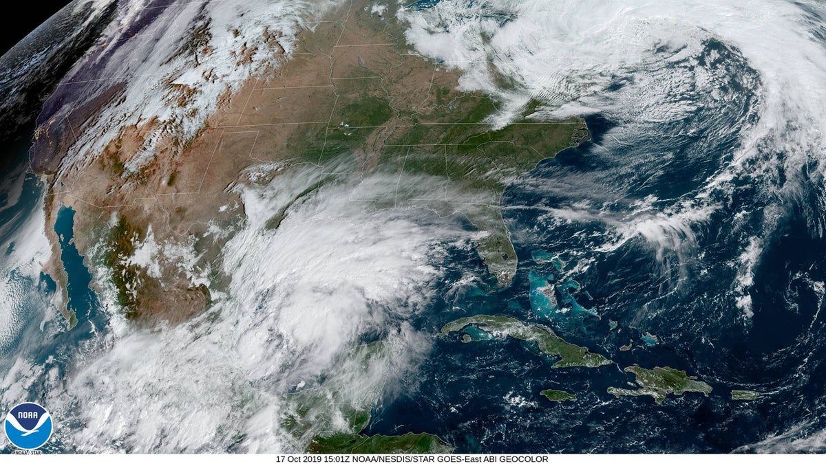
Potential Tropical Cyclone 16, which could become Tropical Storm Nestor, is seen in the southwest Gulf of Mexico on Thursday. (NOAA/GOES East)
Tropical storm warnings have been issued from the Mississippi/Alabama border to the Ochlockonee River, Fla. and from Grand Isle, La. to the mouth of the Pearl River. A storm surge watch is in effect from Indian Pass to Clearwater, Fla.
The storm is forecast to make a turn toward the northeast by Thursday afternoon or later, and then move in a northeastward motion "at a faster forward speed" by Friday into Saturday.
"On the forecast track, the system will approach the northern Gulf coast Friday and Friday night," the NHC said.
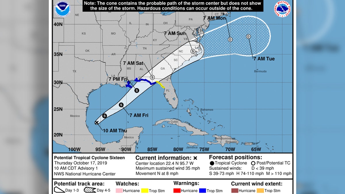
The forecast track of Tropical Cyclone 16, which could become Tropical Storm Nestor., (National Hurricane Center)
Forecasters said that tropical-storm-force conditions are expected to reach coastal areas by late Friday, "making outside preparations difficult or dangerous."
Besides the wind, the system is forecast to bring between 2 to 4 inches of rain across the central Gulf Coast, northern and central Florida, and the eastern Carolinas with isolated five-inch amounts.
Nestor could also bring the threat of a storm surge of up to 5 feet in some locations.
"The combination of a dangerous storm surge and the tide will cause normally dry areas near the coast to be flooded by rising waters moving inland from the shoreline," the NHC said. "The water could reach the following heights above ground somewhere in the indicated areas if the peak surge occurs at the time of high tide."
CLICK HERE FOR THE FOX NEWS APP
If the system strengthens into a tropical storm, it would be the 14th named storm of the 2019 Atlantic hurricane season.
The National Oceanic and Atmospheric Administration has said it expects 10-17 named storms this hurricane season, with winds of 39 mph or higher, of which five to nine could strengthen into hurricanes. Of those storms, there will be two to four major hurricanes, which are classified as Category 3, 4, and 5 with winds of 111 mph or higher.
The 2019 Atlantic Hurricane Season runs from June 1 to Nov. 30, and this year includes the names: Andrea, Barry, Chantal, Dorian, Erin, Fernand, Gabrielle, Humberto, Imelda, Jerry, Karen, Lorenzo, Melissa, Nestor, Olga, Pablo, Rebekah, Sebastien, Tanya, Van, and Wendy.

The hottest stories ripped from the headlines, from crime to courts, legal and scandal.
