
Fox News Flash top headlines for June 19
Fox News Flash top headlines are here. Check out what's clicking on Foxnews.com.
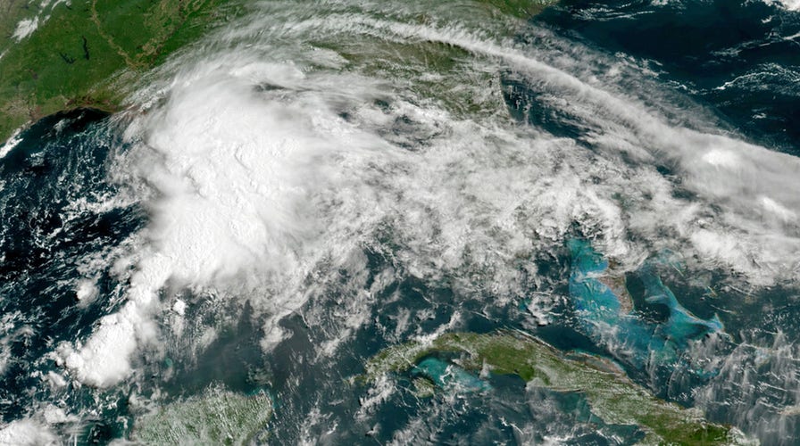
Tropical Storm Claudette made landfall southwest of New Orleans Saturday morning and slammed coastal communities with rain and flooding.
Heavy rain and gusting winds were expected to continue to pummel the northern Gulf Coast as the storm moved from Louisiana across Mississippi and Alabama.
Tropical storm warnings along the Gulf Coast were lifted as of Saturday evening as the storm continued its northeastern drive, and the Southeastern U.S. was expected to see three to six inches of rainfall throughout as the storm passed through.
Tropical storm watches were also issued from Cape Fear to Duck, N.C., and in Pamlico and Albemarle Sounds, according to the National Weather Service.
From there, the storm is expected to turn northeast and weaken into a tropical depression Sunday before regaining strength over the Carolinas late Sunday night or early Monday morning.
Claudette also spawned a suspected tornado that slammed through at least 50 homes in Alabama just north of the Florida border, flattening a mobile home park, tossing trees through homes and even blew the roof off of a high school gym.
There were no early reports of serious injuries or deaths.

This photo provided by Alicia Jossey shows debris covering the street in East Brewton, Ala., on Saturday, June 19, 2021. Authorities in Alabama say a suspected tornado spurred by Tropical Storm Claudette demolished or badly damaged at least 50 homes in the small town just north of the Florida border. (Alicia Jossey via AP) (Alicia Jossey via AP)
In Florida, whipping winds knocked over an 18-wheeler, which slide through multiple utility poles and caused one to slam into an SUV – and another possible tornado ripped the roofs off of two houses.
Louisiana and Mississippi saw flash flooding and heavy rains.
The National Hurricane Center declared Claudette a named storm at 4 a.m. Saturday, after the storm made landfall southwest of New Orleans. By Saturday evening, it was 95 miles west of Montgomery, Alabama, with maximum sustained winds of 35 mph. It was moving north-northeast at 16 mph. Most of the heavy weather was happening far to the north and east of the center.
At 7:50 a.m. ET, the National Oceanic and Atmospheric Administration's (NOAA) National Hurricane Center (NHC) said that that the third named storm of the 2021 Atlantic hurricane season had shifted "Inland Over Southeastern Louisiana."
"Heavy Rains and Tropical-Storm-Force Winds Continue Along Portions of the Northern Gulf Coast," the agency announced on Twitter.
In an advisory posted to Facebook, the NHC said Claudette was centered inland over southeast Louisiana about 30 miles north of New Orleans and moving toward the north to the northeast near 12 mph.
"A turn toward the northeast is expected later today, followed by a motion toward the east-northeast tonight or Sunday. On the forecast track, the system should move farther inland over Louisiana during the next few hours, move across portions of the southeastern states later today and on Sunday, and then over the western Atlantic Ocean on Monday," the agency explained.
Maximum sustained winds for Claudette reportedly remain at around 45 mph with higher gusts and tropical-storm-force winds extend outward up to 205 miles east from the center.
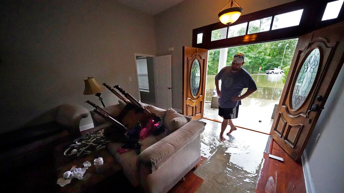
Danny Gonzales, walks in his flooded house as water recedes, after Tropical Storm Claudette passed through, in Slidell, La., Saturday, June 19, 2021. The National Hurricane Center declared Claudette organized enough to qualify as a named storm early Saturday, well after the storm's center of circulation had come ashore southwest of New Orleans.(AP Photo/Gerald Herbert)
The NHC noted that a National Ocean Service station on Petit Bois Island, Miss. had recently recorded maximum winds of 39 mph with a gust to 46 mph.
The NHC said Claudette is expected to weaken to a tropical depression by Saturday night, become a post-tropical cyclone on Sunday and re-develop as a tropical storm over the western Atlantic Ocean on Monday.
Nevertheless, the storm was expected to produce heavy rainfall and life-threatening flash flooding across coastal Mississippi and Alabama, and the far western Florida Panhandle through the afternoon.
Considerable flash, urban and small stream flooding impacts – in addition to "new and renewed minor to isolated moderate river flooding" – were also anticipated to continue throughout the weekend along the Gulf Coast, with flood impacts spreading northeastward into the interior Southeast.
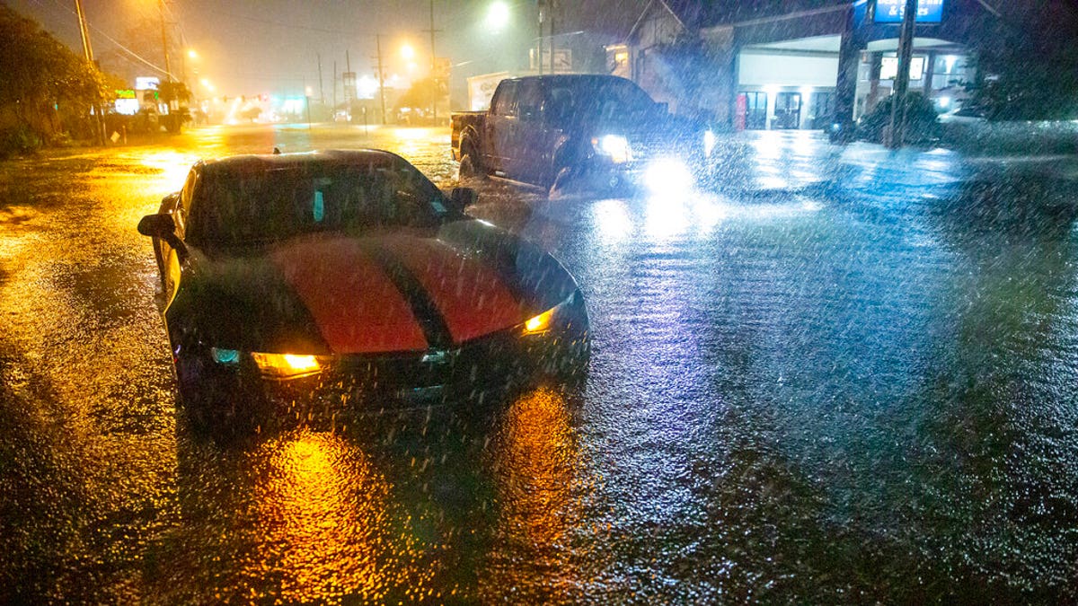
Motorists navigate a flooded Gause Boulevard in Slidell, La., late Friday, June 18, 2021, as a tropical disturbance neared the Louisiana shore. Tropical Storm Claudette has formed Saturday morning along the U.S. Gulf Coast, bringing heavy rains and flooding to coastal states including Louisiana, Mississippi and Alabama. (Scott Threlkeld/The Advocate via AP)
Flooding had already begun on Friday night, with local media reporting high water over roads, stranded vehicles and water rescues; flood warnings and watches were in effect in addition to a widespread tropical storm warning.
"Tropical storm conditions are occurring along portions of the central Gulf Coast from east of Morgan City, Louisiana, to the Okaloosa/Walton County line, Florida, including New Orleans. These winds will spread inland and continue through this afternoon," the NHC warned in a Twitter post.
A Tropical Storm Warning is in effect for the areas east of Morgan City to the Okaloosa/Walton County line, including Lake Pontchartrain, Lake Maurepas, and Metropolitan New Orleans.
Claudette is expected to produce rainfall totals of five to ten inches and isolated areas of 15 inches across areas in the central Gulf Coast.
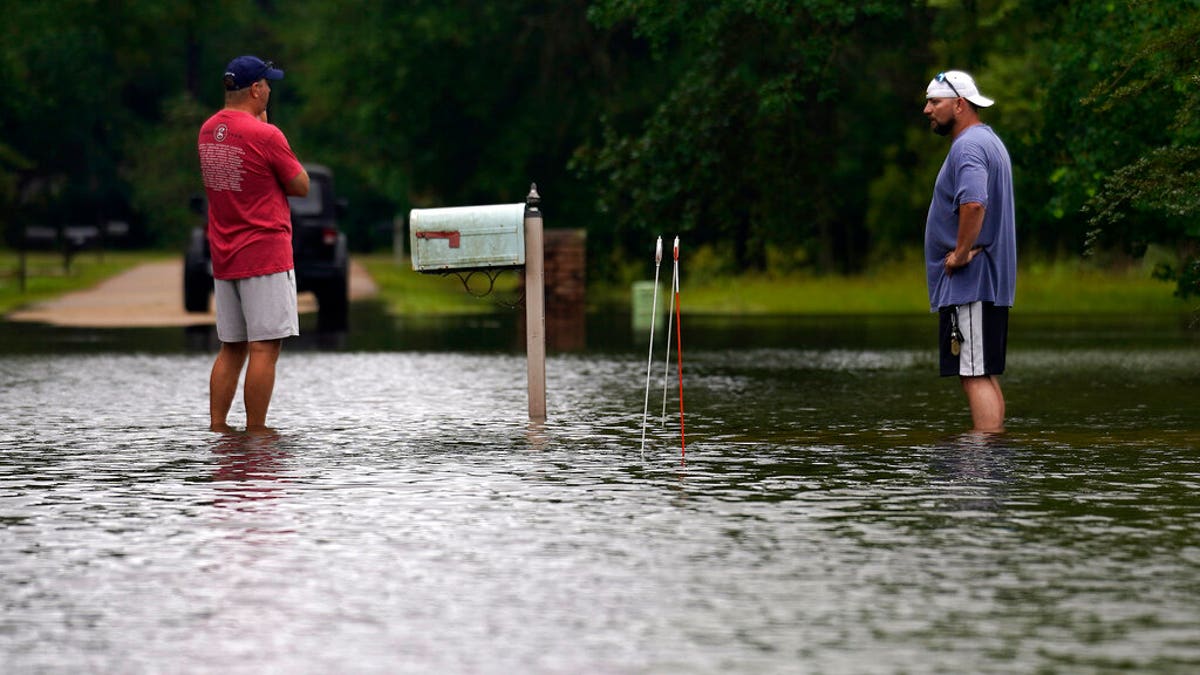
Danny Gonzales, right, stands in front of his flooded house with his neighbor Bob Neal, upset with power company trucks driving though the flooded neighborhood pushing water back into his home, after Tropical Storm Claudette passed through, in Slidell, La., Saturday, June 19, 2021. The National Hurricane Center declared Claudette organized enough to qualify as a named storm early Saturday, well after the storm's center of circulation had come ashore southwest of New Orleans. (AP Photo/Gerald Herbert)
By Friday, up to four inches of rain per hour was falling on parts of the Louisiana and Mississippi coasts.
CLICK HERE FOR THE FOX NEWS APP
Additionally, the NHC said a few tornadoes were possible Saturday across southern Mississippi, southern Alabama, the western Florida Panhandle and southwest Georgia and tornado warnings were widely issued.
All of this comes as the Southwest and western U.S. has been impacted by a sweltering and relentless heatwave and as Mexico was threatened by Tropical Storm Dolores, which was expected to make landfall on its west-central coast Saturday night.
The Associated Press Contributed to this report.
The Associated Press contributed to this report,

The hottest stories ripped from the headlines, from crime to courts, legal and scandal.
