
California storm brings rain, wind, snow and mudslides
FOX News correspondent Jeff Paul has the latest developments on 'America Reports'
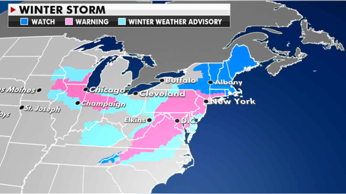
A major snowstorm has hit the Northeast on Monday, with the New York City area potentially seeing up to 24 inches of snow, according to the National Weather Service (NWS).
NYC's emergency notification system on Monday morning advised residents that roads may be dangerous due to hazardous conditions and winds could bring down tree branches, as well as, cause power outages.
Mayor Bill de Blasio ordered a state of emergency on Sunday in anticipation of the winter storm.
Starting at 6 a.m., "nonessential travel will be restricted in New York City," the mayor tweeted.
"Make no mistake: this winter storm will be dangerous with heavy snowfall and strong winds," de Blasio said. "If you can stay home, stay home. Keep the roads clear for emergency vehicles."
Citing the New York City Emergency Management, de Blasio said the city will see "blizzard-like conditions periodically, with up to 2-4 inches of snowfall per hour after 10 a.m. tomorrow. The city will see sustained winds of 20-30 mph, with gusts up to 40-50 mph."
Essential workers, he said, are exempt from the stay-at-home order.
According to the NWS Eastern Region, winds will increase on Monday night and heavy snow bands are expected to develop.
NOR'EASTER TO SLAM EAST COAST, MID-ATLANTIC
The New York City area, along with parts of New Jersey, Pennsylvania, and New York, could see up to two feet of snow between 5 p.m. Sunday through 7 a.m. Wednesday, the NWS wrote in a 5:30 p.m. update.
In NYC, LaGuardia Airport, said approximately 81% of flights have been canceled.
Meanwhile, the Long Island Rail Road (LIRR) tweeted that trains will be running on a weekend schedule Monday due to the winter storm hitting the region. The commuter rail system urged residents to "stay home if you can and avoid all unnecessary travel."
"If snow accumulations reach 10-to-13 inches, we may need to temporarily suspend service for the safety of customers and employees and so we can clear snow from the tracks," according to the LIRR early Monday. "If you must travel, please use caution on station staircases/platforms & when boarding/exiting trains."
Bus service in and out of the Port Authority Bus Terminal will also be suspended today.
It would be the first time in at least five years that New York City gets hit with more than a foot of snow during one storm, the New York Post reported.
The storm made its way across the Midwest over the weekend before turning up along the Mid-Atlantic towards New England, bringing over a foot of snow in some parts of the country.
White House officials said the weather warnings have caused President Joe Biden's visit to the State Department on Monday to be rescheduled.
The storm started in California, bringing rare snow to some parts of the state before heading out across the central plains. The system gained strength as it moved across the country, eventually dropping snow across Chicago and the Ohio Valley.
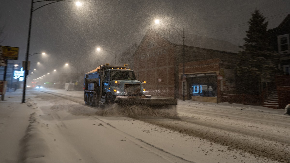
A snow plow clears streets during a Winter Storm Warning in Chicago, IL on January 30, 2021. Up to 10 inches of snowfall is expected this weekend. (Photo by Max Herman/NurPhoto via Getty Images)
Saturday saw a number of major roadways closed as snow started to come down thick and fast across the Midwest.
AS SNOWSTORM LOOMS, DC'S DELEGATE TO CONGRESS SEEKS OK FOR KIDS TO SLED OUTSIDE CAPITOL
As of Sunday morning, Chicago had seen approximately seven inches of snow, according to Accuweather. Detroit and Cleveland had seen a little under six inches, with more coming across the day.
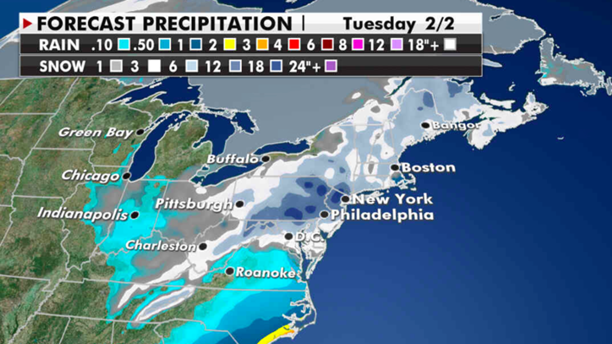
Sunday sees mixed precipitation, with rain and thunderstorms in the south before the storm heads north and turns to heavy snow across the northeast.
Some states in the Northeast could possibly see more than three feet of accumulation.
The storm is expected to weaken over the Midwest on Sunday evening, and rain in the Southeast will head offshore by Monday morning.
CLICK HERE TO GET THE FOX NEWS APP
A new storm will form and move through the Southwest midweek, starting the cycle over again.

The hottest stories ripped from the headlines, from crime to courts, legal and scandal.
