


New Orleans looking underground as parts of city sink
Researchers believe managing flow of water in and out of city could help.
NEW ORLEANS – “I know where I live,” said Keith Daggett.
Daggett’s home sits by the London Avenue Canal. The floodwall along the canal breached during Hurricane Katrina more than 13 years ago. An outdoor exhibition now stands at the site of the devastation, marking the flooding caused by the failures of the canal.
“Yes, there is a flood risk here,” said Daggett, who recently moved to the neighborhood.
Tulane University environmental sciences professor Alex Kolker reiterated that the future of the area looks dire.
“The neighborhood lies eight to 10 feet below the canal, and that’s an enormous flood risk,” said Kolker.
Hydrogeologists said the city sinks 6 to 8 mm a year. A large part of the city is already below sea level, and the Gentilly neighborhood, where Daggett lives, is one of the fastest sinking areas.

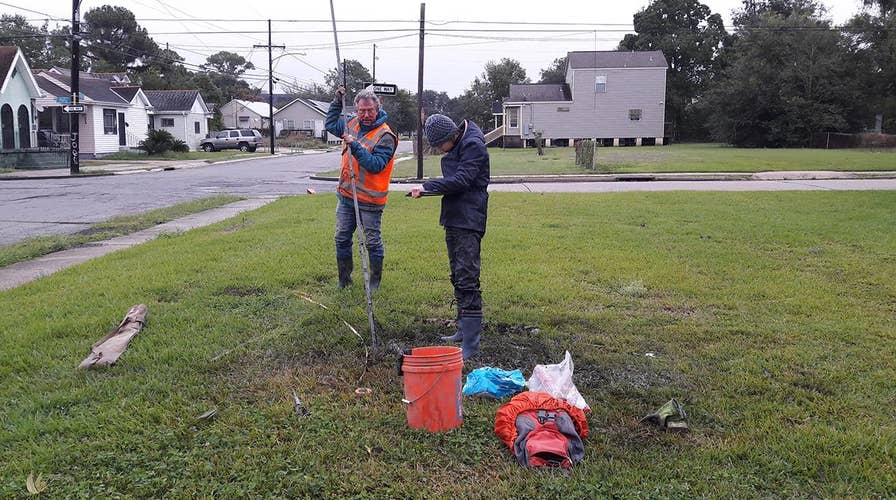
Dutch-based company Deltares drilling in New Orleans. It's part of a bigger project to make the city resilient in relation to climate change and sea level rise. (Deltares)
Kolker is part of a team of researchers, which includes Dutch-based research institute Deltares and the Water Institute of the Gulf, trying to figure out which sections of the city are sinking, how fast, and why. They say subsidence was one reason why Katrina was catastrophic. Water flooded the low-lying areas and had to be pumped out.
“After having experienced the damaged city in 2006 and working there all those years after, New Orleans became part of me. This project helps to collect the missing information needed to take appropriate measures to ensure the [city] is a safe place in the future in relation to sea level rise and changing climate dynamics,” said Roelof Stuurman, a water specialist at Deltares.
The city-led project called “Reshaping the Urban Delta” is being funded by a $141.3 million grant from the Department of Housing and Urban Development. It largely focuses on the city’s subsurface.
As the first comprehensive resilience district in the Gentilly neighborhood, the city said, the project includes over $90 Million in urban water management projects that largely focus on the city’s subsurface.
“We cannot manage what we don’t understand; so the first step is to ground truth the assumptions we’ve made from past studies and build upon the best available science,” said Tyler Antrup, urban water program manager from the city’s Office of Resilience and Sustainability.
Experts theorize the underlying geology could be one reason for the sinking, also known as subsidence.
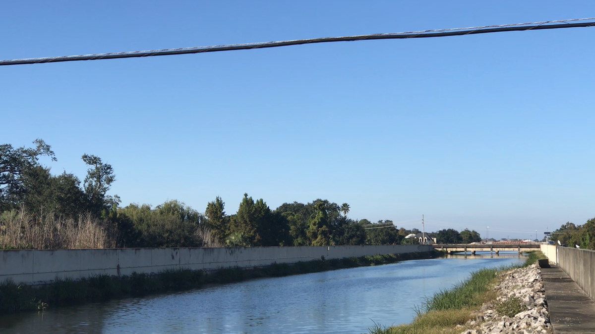
Homes by the London Avenue Canal in New Orleans sit eight to 10 feet below the canal, a flood risk for residents in the area. (Fox News)
“There’s a whole bunch of old swamps beneath the city of New Orleans and when these swamps dry out the ground they take compact and compress and the ground above them sinks,” said Kolker.
Cracked pipes could also play a part.
“Water and mud can flow into them and erode the ground around them. And then you'd create a hole, and that hole is almost a sinkhole,” added Kolker.
Stuurman believes managing the way water flows in and around the city could mitigate the rate of subsidence. Last week, Deltares led a group on several soil drilling operations around the city taking sediment samples, the first step of this study.
“The objective was to determine the ‘mean lowest groundwater level’ and the amount of organic material in the soil and clay saturation because these determine the subsidence risk,” said Stuurman.
New Orleans is not alone in this ordeal. Tokyo and even parts of the Houston-Galveston area have sunk as well, particularly in the middle of the 20th century.
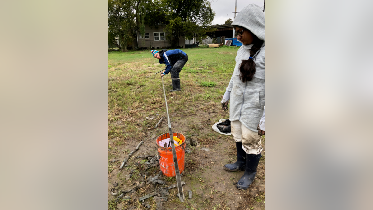
The project will take about 18 months, culminating with the design and installation of an integrated water monitoring network. (Tulane University)
“There, they did take a lot of effort to better monitor the rate at which they pulled out ground water. And, that did help slow the subsidence in (the Houston-Galveston area),” said Kolker.
Researchers said there’s an added sense of urgency as storms, especially in the Gulf Coast region, are expected to become stronger, thanks to climate change.
“New Orleans is one of the most vulnerable cities in the United States [due] to the impacts of climate change and sea level rise. As we see more frequent and intense rainfall events, we have to adapt by living with water, reducing the subsidence of our soils, and preserving the quality of life and culture of our City,” said Antrup.
The entire study will take about 18 months, culminating with the design and installation of an integrated water monitoring network.
“Knowing that they are at least addressing the problem, to whatever degree,” Daggett said, “does give me some comfort.”
Fox News Artificial Intelligence
Stay up-to-date on the latest AI technology advancements and learn about the challenges and opportunities AI
By entering your email and clicking the Subscribe button, you agree to the Fox News Privacy Policy and Terms of Use, and agree to receive content and promotional communications from Fox News. You understand that you can opt-out at any time.