


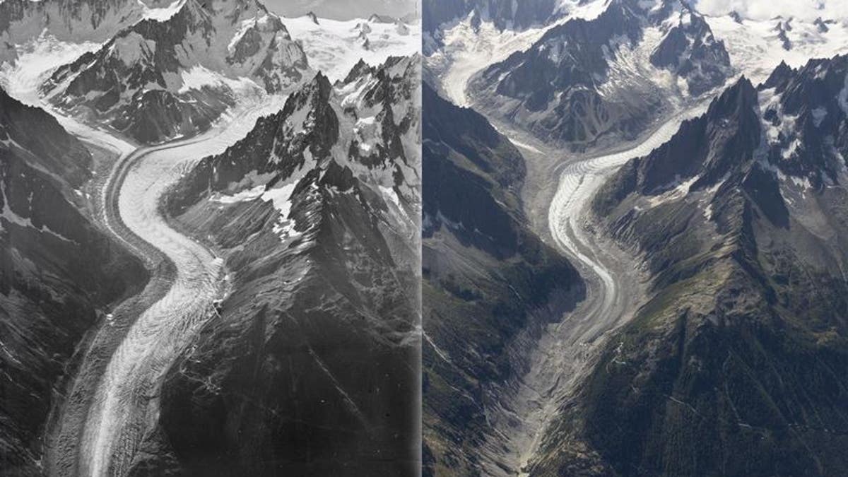
Comparison composition that shows Mer de Glace glacier from 1919 left, to today. (Walter Mittelholzer, ETH-Bibliothek Zürich & Dr Kieran Baxter, University of Dundee)
Stunning new aerial photographs of Mont Blanc reveal the extent of ice loss over time in the Alps.
A century ago, the Swiss pilot and photographer Walter Mittelholzer flew over Mont Blanc in a biplane to photograph the alpine landscape. In August, researchers from the University of Dundee in Scotland re-created his photographs to show how the mountains have changed over time.
Kieran Baxter and Alice Watterson from the 3DVisLab at Duncan of Jordanstone College of Art and Design, part of the University of Dundee in Scotland, flew over the Mont Blanc massif to repeat three of Mittelholzer's iconic photographs of the glaciers.
ANTARCTICA ICE SHELVES' EDGES BEING ATTACKED BY WARM OCEAN WATER, STUDY REVEALS
Scientists used a process called "monoplotting" to find the original camera position in airspace; then they used the peaks and spires of the alpine landscape as anchor points to find the geolocation of the historical images.
The new photographs of the Argentiere, Mont Blanc Bossons and Mer de Glace glaciers show the large scale of ice loss in the region.
Dr Baxter, equipped with waypoints from the digital analysis and multiple GPS devices, hung from the side of the helicopter as it hovered just below the summit of Mont Blanc to capture the photographs.
AMAZON SPOKESMAN BLASTED FOR QUESTIONING PATRIOTISM OF TRUMP ADMINISTRATION OFFICIALS
"The scale of the ice loss was immediately evident as we reached altitude but it was only by comparing the images side-by-side that the last 100 years of change were made visible. It was both a breathtaking and heartbreaking experience, particularly knowing that the melt has accelerated massively in the last few decades," said Kieran Baxter, of the University of Dundee, in a statement.
"Unless we drastically reduce our dependence on fossil fuels, there will be little ice left to photograph in another hundred years," Baxter warned.