


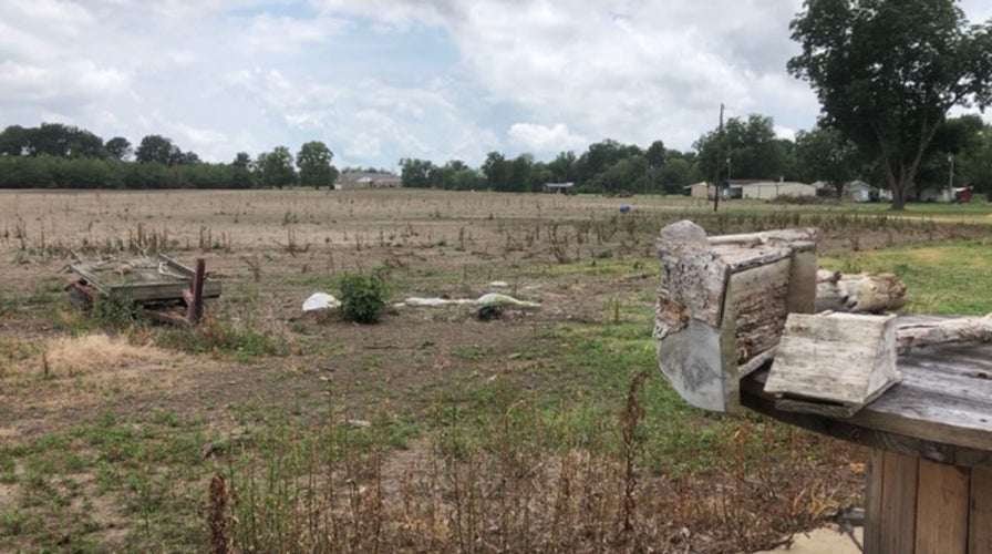
Mississippi Delta farmers feel impact of multiple floods and COVID-19
Multiple floods and low commodity prices are making it nearly impossible for Mississippi Delta farmers to make a profit in the midst of the coronavirus pandemic.
Millions of properties nationwide are at risk of severe flooding over the next three decades, but their neighborhoods are not included on federal disaster-preparedness maps, according to an analysis released Monday.
The study from the First Street Foundation, a nonprofit research and technology group, examined flood risk data for more than 142 million homes and properties to give American homeowners a better idea of how vulnerable their properties are to flooding.
"I do think that this will be a bit of a shock to some folks," First Street Executive Director Matthew Eby told FOX13.
LIGHTNING DEATHS DROP 'DRAMATICALLY' OVER 2 DECADES ACROSS US, BUT DANGER STILL LINGERS
The nonprofit developed its model using the effects of rainfall, sea-level rise, and other anticipated environmental changes to find that 14.6 million properties in the U.S. may face conditions as those located on the 100-year floodplain classified by the Federal Emergency Management Agency (FEMA).
FEMA currently classifies 8.7 million properties on floodplain maps as having substantial risk.
A national view of flood risks, according to Flood Factor's map. (First Street Foundation / Flood Factor)
The online tool, called Flood Factor, uses decades of research to include environmental factors like rising sea levels, temperature change and rainfall patterns to formulate risk. The idea is to give users an assessment through the life of a 30-year mortgage and gauge each property's flood risk on a scale of flooding from one to 10.
"We built this product because we saw a gap in the market for how people understand risk today and how it changes in the future," Eby told FOX13.
NEW APP RANKS 142M US PROPERTIES FOR FLOOD RISKS
Its creators said that current FEMA models only rely on historical observations.
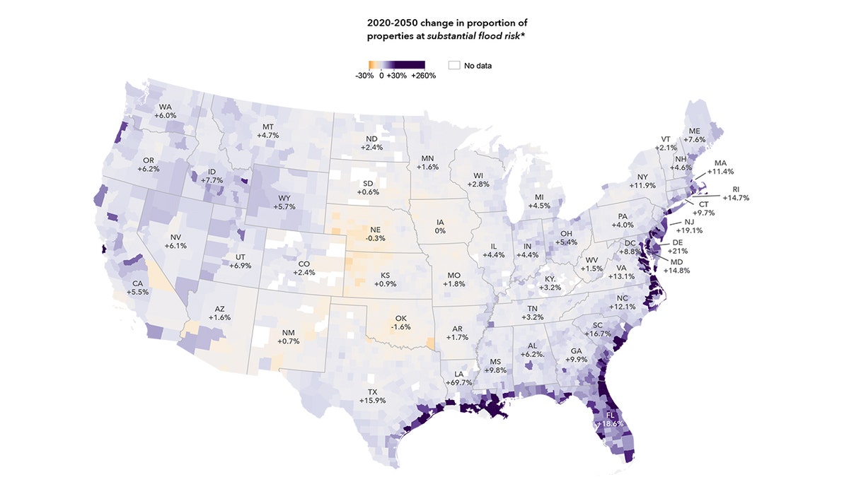
In Florida, Flood Factor showed that by 2050 1 out of every 4 homes in Florida will have a substantial flood risk, an increase of more than 300,000 homes.
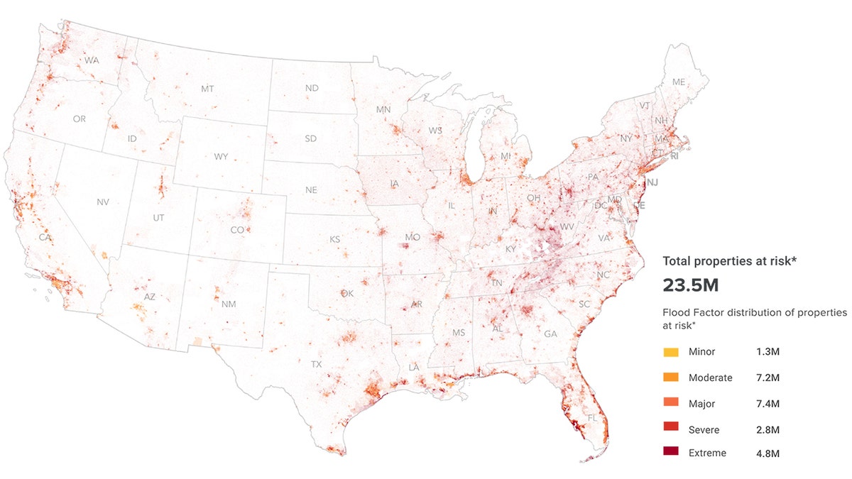
The total number of properties at risk on Flood Factor's map. (First Street Foundation / Flood Factor)
"So there is a huge increase in flood risk that is happening over that short, 30-year period within the state itself," Eby told FOX13.
A FEMA spokesperson told Fox News on Tuesday that the two different risk maps by the agency and First Street "complement" one another by depicting different types of risk and will be helpful in different ways for someone to determine their individual flood risk.
The agency encourages people to explore the differences between the maps to build a greater understanding of flood risk.
FEMA has not evaluated the Flood Factor tool but said that it may help someone take action to reduce their individual flood risk. The agency said it believes the level of accuracy necessary to inform someone's decision whether or not to acquire flood insurance is "adequately serviced" by FEMA maps.
"We’re encouraged to see First Street Foundation building on federal agency datasets and the information included in our flood maps to bring together new data and technology in order to visualize flood hazard information in a different and useful way," a spokesperson said.
CLICK HERE FOR MORE WEATHER COVERAGE FROM FOX NEWS
David Maurstad, FEMA's deputy associate administrator for insurance and mitigation, pointed to FEMA's flood maps being the "backbone" of floodplain management. He said local adoption of minimum standards based on those maps saved about $100 billion in losses over the last 40 years.
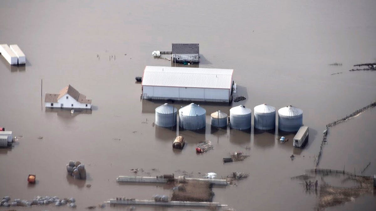
This March 18, 2019 photo taken by the South Dakota Civil Air Patrol and provided by the Iowa Department of Homeland Security and Emergency Management, shows flooding along the Missouri River in rural Iowa north of Omaha, Neb. Nearly 6 million more properties are at risk for flooding than FEMA estimates in a new analysis. (Iowa Homeland Security and Emergency Management)
"FEMA is constantly working to improve the production of the Flood Insurance Rate Maps within the context of changing conditions," he said in an emailed statement. "We’re exploring ways to leverage new technologies and provide flood information more efficiently, accurately, and consistently across the nation."
FEMA's existing flood maps have drawn previous concerns over underestimating flood risks and updating those maps can ignite drawn-out fights between homeowners and politicians to avoid higher federal flood insurance rates.
CLICK HERE FOR THE FOX NEWS APP
The agency said it's "continuously working" with partners to develop a more comprehensive picture of flood hazard and risk across the nation.
"FEMA, our governmental partners, academia, and private sector entities like the First Street Foundation are all working towards the same goal: to improve the nation’s understanding of flood risk and reduce disaster suffering in our nation," a spokesperson told Fox News.