


Fox News Flash top headlines for June 23
Fox News Flash top headlines are here. Check out what's clicking on Foxnews.com.
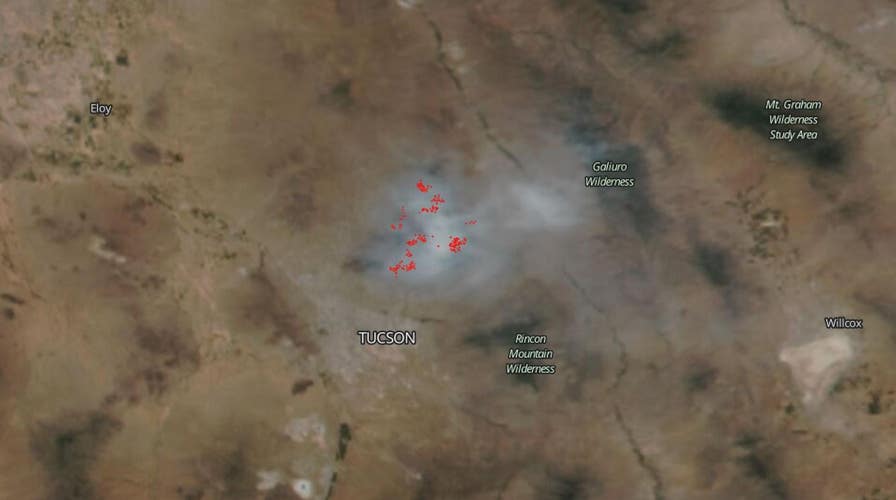
NOAA/NASA's Suomi NPP satellite on Monday captured a stunning image of a vast bush fire plaguing Arizona.
The picture shows clouds of smoke stretching 63 miles pouring off the fire, which grew overnight to 186,848 acres, growing 2,200 acres overnight. The fire was 61 percent contained as of Tuesday.
The National Weather Service (NWS) forecast calls for weather in Tucson to continue to be hot and dry with temperatures set to reach 105 degrees Fahrenheit.
COVID-19 LOCKDOWN REVEALS HUMAN IMPACT ON WILDLIFE, RESEARCHERS SAY

NOAA/NASA Suomi NPP satellite image is seen above. (NASA Worldview)
LARGE HYBRID SEA TURTLE PARTAKES IN 'RACE' NEAR FLORIDA KEYS
"Hot temperatures for the remainder of the work week under high pressure aloft. The hottest days will be tomorrow and Thursday [June 25]. A few lower elevation areas could be as hot as 110 to 111 degrees both days. This is normally the hottest time of the year," the NWSD discussion on June 23 said.
The space agency's satellite instruments tend to be the first to detect wildfires burning in remote regions, and the coordinates of new fires are sent directly to land managers worldwide within hours of the satellite overpass.
NASA instruments have the capability to detect active fires, track the smoke billowing from fires, give information to authorities, and even reveal the extent of changes to ecosystems, based on the extent and severity of burn scars.