
Gulf Coast braces for tropical storms Marco and Laura
Louisiana prepares for back-to-back storms; Bryan Llenas reports.
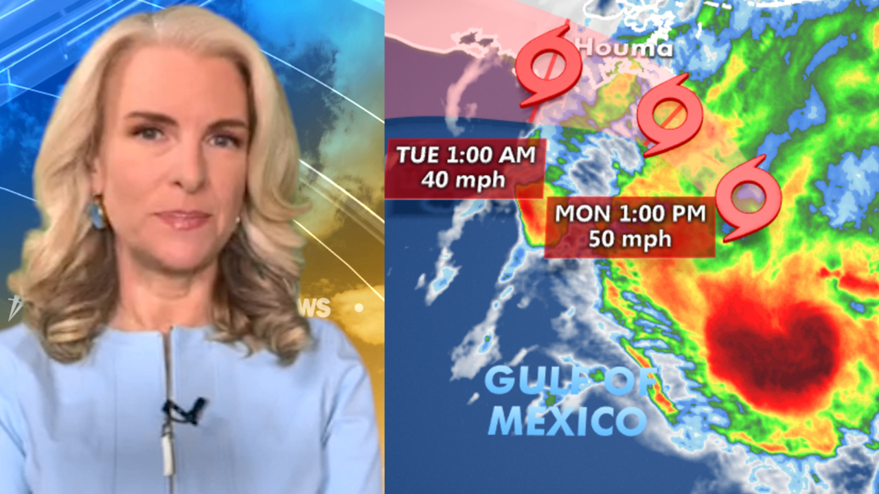
Tropical Storm Marco is producing heavy rainfall and gusty winds along portions of the U.S. Gulf Coast Monday as the system is moving closer to Louisiana, the National Hurricane Center says.
Marco, which has weakened from hurricane strength, is currently about 55 miles south-southeast from the mouth of the Mississippi River, and is moving north-northwest, according to the Center’s latest advisory.
"A turn to the west-northwest is expected to occur by Tuesday, and this motion should continue until the system dissipates in a couple of days," it said.
TROPICAL STORMS MARCO, LAURA PUT US COASTLINES ON ALERT

Liz Mcalpine pulls a flag from down her boat in Lake Pontchartrain as she prepares for Tropical storm Marco and Tropical storm Laura on August 23, 2020, in New Orleans, Louisiana. (Photo by Sean Gardner/Getty Images)
A previous advisory stated that “Marco is forecast to approach the coast of Louisiana this afternoon, and then turn westward and move very close to the coast of Louisiana through Tuesday night."
Tropical and storm surge warnings remain in effect for a stretch of the Louisiana and Mississippi’s coastlines, including the metropolitan New Orleans area.
“Marco is expected to produce total rainfall accumulations of 3 to 6 inches with isolated maximum amounts of 10 inches across portions of the northeast and north-central Gulf coast through Tuesday,” the National Hurricane Center says. “This rainfall may result in areas of flash, urban and small stream flooding.”
National forecast for Monday, August 24
Fox News senior meteorologist Janice Dean has your FoxCast.
The National Hurricane Center also says the “combination of a dangerous storm surge and the tide will cause normally dry areas near the coast to be flooded by rising waters moving inland from the shoreline.”
MARCO, LAURA CAPTURED ON NASA SATELLITE IMAGES
As of late Monday morning, Marco’s maximum sustained winds have decreased to around 50 mph with higher gusts.
“Steady weakening is forecast, and Marco is expected to weaken to a tropical depression tonight, and degenerate to a remnant low on Tuesday,” the advisory added.
"A couple of tornadoes are possible today into tonight across the Florida Panhandle, southern Georgia, southern Alabama, and southern Mississippi," it also said.
CLICK HERE TO GET THE FOX NEWS APP
Meanwhile, Tropical Storm Laura is forecast to move along Cuba's southern coast Monday before entering the Gulf of Mexico and heading toward the same stretch of U.S. coast later in the week, most likely as a hurricane.
“Tropical Storm Laura could bring additional storm surge, rainfall, and wind impacts to portions of the U.S. Gulf Coast by the middle of the week,” said the National Weather Service in an advisory. “This could result in a prolonged period of hazardous weather for areas that may also be affected by Marco. Interests there should monitor the progress of Marco and Laura and updates to the forecast during the next few days.”
The Associated Press contributed to this report. Follow James Rogers on Twitter @jamesjrogers

The hottest stories ripped from the headlines, from crime to courts, legal and scandal.
