


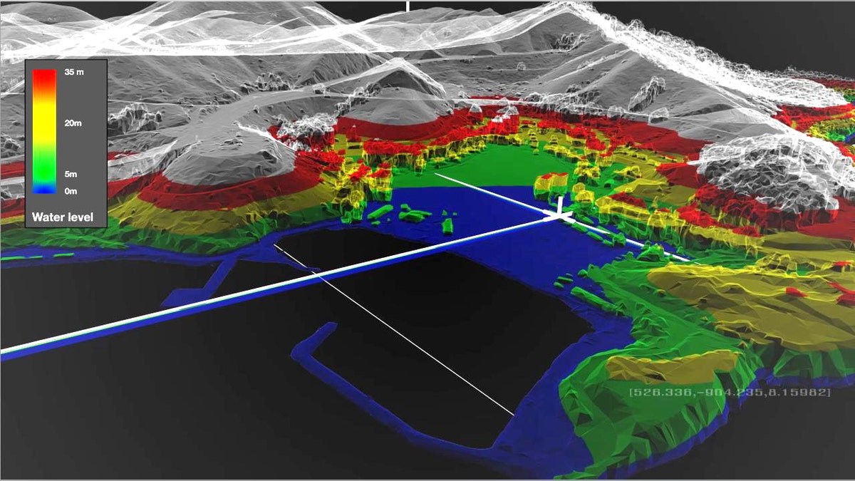
Saab's brand new military technology can create an incredibly detailed and accurate 3D map of a battlefield -- and shows troop and vehicle movements in real time. (Saab)
Maps may not sound sexy. But Saab's real-time 3D maps will nonetheless make your eyes pop.
Remember those magic maps from the Harry Potter books that tracked the location of every wizard at Hogwarts -- down to the last footstep? Saab’s Rapid 3D Mapping is far, far cooler.
FoxNews.com can exclusively reveal this never-before-seen military technology, which can create an incredibly detailed and accurate 3D map of a battlefield and -- with the help of footage from a nearby drone as an overlay -- provide real-time information on the war zone. These maps are "geo-referenced," meaning they incorporate latitude, longitude and height, and they’re accurate to within an amazing four inches.
"We truly believe that Rapid 3D Mapping will revolutionize the field of geospatial intelligence and the way military and security forces get access to much needed accurately geo-referenced data," Saab director Michael Olofsson told FoxNews.com.
Given that this is cutting-edge technology, Saab's Olofsson won't explain exactly how it works, other than in general terms -- it uses aerial images from aircraft, UAVs, helicopters and satellites to build its terrain maps. All the company needs is the exact location of a camera in the sky to work out precise angles.
Once built, the potential applications for this technology are limitless.
Suppose a commander wants to find the best spots for snipers in a town he's approaching. Because every pixel is geo-referenced, he can place a virtual sniper within the Saab map to study his 360-degree point of view and find the best vantage point.
The commander can also anticipate who can see him and from where, to discover where enemy snipers might already be lurking.
En route to the town, let’s say his platoon falls under attack. With a live feed from an unmanned aircraft (UAV) or even sensors on a patrol vehicle, he can get the full picture of the surroundings on a real-time 3D map instantly -- not five hours later.
IEDs are an ongoing threat to forces. With UAV footage, Saab's maps can identify changes in soil in the route that lies ahead that may signify a recently hidden IED.
Traditionally, 3D mapping had to be executed by hand -- using a computer, that is. Engineers had to model every building separately, a process that can take months. An alternative technology called LIDAR uses laser scanning to gauge the height of buildings, but that takes even more time -- and to get texture on buildings requires aerial imagery anyway.
Saab's Rapid 3D Mapping processes height and texturizes immediately, and allows one to zoom in on actual war zone terrain to plan.
When capturing data from an aircraft, up to 100 square kilometers can be captured per hour. When aerial spotters are flown at 1,500 feet, each pixel is accurate to within four inches.
To put it in context, a desert would take an hour to image; a complete 3D map of 100 square kilometers could be built in five. Urban areas take slightly longer, because there is more data when there are lots of tall buildings: Downtown Manhattan, for example, would take about five hours to capture and therefore 15 hours to map.
There are a range of important homeland security applications for this technology, as well, notably security cameras: By using the “virtual sniper” application, one can plan optimal coverage of security cameras in a virtual environment -- or scan for potential threats if, say, the president were paying a visit to town.
In a flood or other disaster, Rapid 3D Mapping could map water levels and indicate what areas are affected and where there is rising water. In a first-responder command and control center, it can give an accurate picture of the civilian space showing where police, fire, helicopters and other support are located. When a person rings in, a dispatcher can ask the caller to describe the environment and enter this information into the model so that first responders can identify how to send help most effectively.
3D Rapid Mapping brings the black box to the soldier in the field. It takes thousands of photos and uses only the very best, Saab claims, therefore reducing the data volume by 40 to 60 times. All that's needed is a laptop or handheld to look at the data. It can even be used on iPhones, iPads or smartphones.
Now how's that for sexy?
Ballet dancer turned defense specialist Allison Barrie has travelled around the world covering the military, terrorism, weapons advancements and life on the front line. You can reach her at wargames@foxnews.com or follow her on Twitter @Allison_Barrie