


Death toll keeps rising as wildfires ravage several states in the West
Fox News Contributor Christina Coleman reports from Monrovia, California.
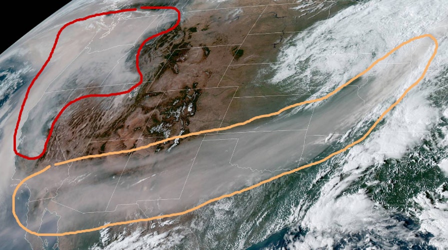
A vast pall of smoke from the West Coast wildfires has been captured in a remarkable satellite image.
The image, tweeted by the National Weather Service Weather Prediction Center, shows smoke stretching as far east as Michigan. The fires have been ravaging California and Oregon.
DEVASTATING WILDFIRE 'ANATOMY' EXPLAINED

The satellite image showing the wildfire smoke. The area in the orange contour is smoke in the mid-upper levels of the atmosphere that has reached Michigan, according to the National Weather Service Weather Prediction Center, which notes that the red contour shows dense smoke near the West Coast. (National Weather Service Weather Prediction Center)
“Here is a visible satellite image valid at 2pm PDT showing the vast extent of the wildfire smoke,” the Weather Prediction Center tweeted Saturday. “The area in the orange contour is smoke in the mid-upper levels of the atmosphere that has reached as far east as Michigan! The red contour is the dense smoke near the West Coast.”
Other satellite images have also shown the incredible scale of the wildfires.
CALIFORNIA AND OREGON WILDFIRES SPOTTED FROM SPACE IN INCREDIBLE SATELLITE PICTURES
The death toll has topped 30 and could increase sharply, with Oregon officials saying they are preparing for a possible “mass casualty event" if more bodies are found in the ash.
CLICK HERE TO GET THE FOX NEWS APP
California has borne the brunt of the death toll so far, as more than two dozen active major fires have burned thousands of square miles. President Donald Trump plans to visit the state Monday for a briefing.
The Associated Press contributed to this article.
Follow James Rogers on Twitter @jamesjrogers