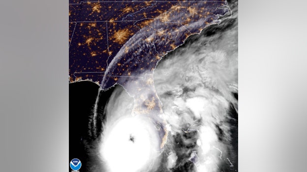
Hurricane Ian downgraded to Category 2, but Florida Gov. Ron DeSantis warns troubles not over
Hurricane Ian made landfall in southwest Florida Wednesday, flooding streets and leaving 2 million people without power. Fox News is updating with the latest news surrounding the storm, its impact, travel and emergency updates.
Coverage for this event has ended.
Hurricane Ian downgraded to Category 2, maximum sustained winds around 105 mph
Hurricane Ian has downgraded to a Category 2 hours after making landfall on the southwest coast of Florida Wednesday afternoon with Category 4 force.
By evening, the storm continued to move northeast through Florida, with maximum sustained winds around 105 mph, down from 150 mph. Winds must be less than 45 mph for rescue crews to save people.
The National Hurricane Center reported that damage from the storm is occurring as the eye moves northward through the state.
Per FOX Weather, a storm surge of up to 18 feet above ground level -- along with destructive waves -- is ongoing along the southwest Florida coastline.
The storm surge is expected to continue Thursday and Friday along the coasts of Northeast Florida, Georgia and South Carolina.
Hurricane Ian downgraded to Category 1, maximum sustained winds around 90 mph
Hurricane Ian has downgraded to a category 1 hurricane, although it continues to batter the Florida Peninsula with maximum sustained winds around 90 mph, storm surges, and major flooding.
As of midnight, the hurricane is about 70 miles south of Orlando.
Global Empowerment Mission to send humanitarian supplies to areas impacted by Hurricane Ian
The Global Empowerment Mission, a disaster relief nonprofit located in Doral, Florida, is sending trucks full of humanitarian supplies to help those impacted by Hurricane Ian.
Two 18-wheelers filled with thousands of family necessity kits (food, toiletries, etc.) and other supplies (tarps, etc.) will be loaded at GEM headquarters Thursday morning and will be delivered directly to the impacted areas in southwest Florida, the nonprofit said.
On Thursday, Global Empowerment Mission founder Michael Capponi will join Miami-Dade County Mayor Daniella Levine Cava at Mission headquarters at approximately 7 a.m. to thank the volunteers who helped pack the trucks before they depart for SW Florida.

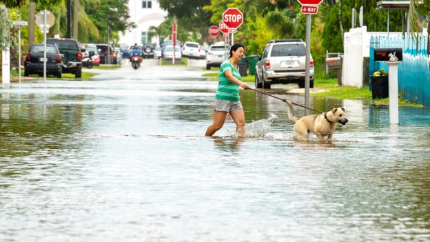
Video shows major flooding of the Caloosahatchee River in Fort Myers
More than 2 million people without power in Florida
More than 2 million Floridians are without power as the Category 2 Hurricane Ian continues to path across the state.
As of 11 p.m. ET Wednesday, reported outages totaled approximately 2,027,852, according to PowerOutage.us.
Florida Gov. Ron DeSantis previously predicted millions would be affected by the massive storm, which made landfall as a Category 4, with sustained winds of 150 mph. Ian has since weakened to a Category 2, with sustained winds of 55 mph, but continues to batter Florida with catastrophic winds and flooding.
Most outages were reported by the Florida Power & Light Company, Duke Energy, and Tampa Electric.
Governors in Florida, Georgia, the Carolinas, and Virginia have all made emergency declarations as Hurricane Ian continues to travel north along the eastern coast.
NCSO Marine Unit rescues two people sailing in the Fernandina Harbor during Hurricane Ian
The Nassau County Sheriff's Office Marine Unit safely rescued two people who were sailing in the Fernandina Harbor. The rescue took place around 8:30 p.m.
"Let this be a reminder not to head out on your boat in these dangerous conditions," the NCSO said.
North Carolina Gov. Cooper declares State of Emergency in response to Hurricane Ian
North Carolina Gov. Roy Cooper on Wednesday declared a State of Emergency after Hurricane Ian made landfall on the southwest coast of Florida.
In a statement, Gov. Cooper said the declaration is needed to allow farmers and those preparing for the storm to get ready for heavy rainfall.
“North Carolinians should stay aware, keep a close eye on the forecast and prepare their emergency supplies,” he said.
Heavy rainfall, possible flooding, and tornadoes is expected on Friday and Saturday from the remnants of Hurricane Ian.
The State Emergency Response Team will activate on Thursday at the State Emergency Operations Center in Raleigh and plans to move to 24-hour operations on Friday morning.
Virginia Gov. Glenn Youngkin declares state of emergency in response to Hurricane Ian
Virginia Gov. Glenn Youngkin on Wednesday declared a state of emergency after Hurrian Ian made landfall on Florida’s southwest coast with Category 4 force. The storm is expected to impact portions of Virginia starting on Friday, September 30.
“Hurricane Ian is a large, powerful storm, and current predictions indicate that it may impact parts of Virginia later this week into early next week,” said Governor Glenn Youngkin in a statement.
“We want to ensure that our communities have the resources needed to respond to and recover from any potential effects from the storm. While we recognize that the storm track is still uncertain, I nevertheless encourage all Virginians and visitors to make a plan, have supplies on hand, and follow official sources for the latest forecast information and guidance. Suzanne and I will be praying for those in Florida in the path of the storm.”
The governor’s State of Emergency declaration will allow Virginia to mobilize resources and equipment needed for response and recovery efforts.
Hurricane Ian: Video shows flooded fire truck being unloaded in Naples, FL
The Naples Fire Rescue Department was forced to push a fire truck flooded by Hurricane Ian out of the bay and unload it because it seemed as if it might catch on fire.
Severe conditions caused by Hurricane Ian descends on Placida, FL
Scenes from Placida, Florida as severe conditions caused by Hurricane Ian descends on the small community.
Hurricane Ian causes flooding, damaging winds Charlotte County, FL
Charlotte County, one of Florida's counties on the Gulf of Mexico, grapples with the extreme conditions caused by Hurricane Ian.
NY Gov. Hochul sending state Army National Guard members to help Florida with Hurricane Ian
"As Hurricane Ian hits the Florida coast, I join all New Yorkers in praying for the safety and well-being of every individual who will be impacted by this terrifying storm," New York Gov. Kathy Hochul said in a statement.
"To assist with relief efforts, I have directed the New York Army National Guard to send two CH-47F Chinook heavy lift helicopters and 11 service members to assist the Florida National Guard and provide airlift support as required. They departed from Army Aviation Support Facility 3 at Frederick Douglass Greater Rochester International Airport and will arrive in Jacksonville, Florida."
"We are grateful for the heroism of these New Yorkers who are answering the call of duty, as well as for the extraordinary efforts of all first responders currently working to provide aid and support to the people of Florida. New York will always stand up and help our neighbors in a time of need."
Ron DeSantis says Ian to rank as ‘top 5 hurricanes’ to hit Florida
Gov. Ron DeSantis on Wednesday provided an update on Hurricane Ian hours after it made landfall in Southwest Florida as a Category 4 storm.
Speaking at a press conference, DeSantis said the storm surge has likely peaked but has done a lot of damage and is going to continue moving through Florida.
“You're going to see hurricane force winds in places in central Florida,” he said. “It's clearly a very strong tropical storm all the way until it exits the Florida peninsula in the Atlantic Ocean.”
He predicted that Hurricane Ian would “rank as one of the top five hurricanes to ever hit the Florida peninsula.”
DeSantis said he had sent a letter to the Biden administration for a major disaster declaration for all of Florida’s 67 counties requesting the federal government do a 100% reimbursement up front for 60 days to help the state move forward with its response and recovery phase.
On recovery efforts, DeSantis said Florida has nearly 250 aircraft, more than six hundred high water vehicles and more than 300 boats of all drafts and sizes, including 250 already stationed in the major impacted areas and nearly 50 that are staged and ready at a moment’s notice.
DeSantis urged people to not let their guard down even after the storm had passed, noting that fatalities in past hurricanes were higher post-storm than before.
“In Hurricane Irma, there were seven fatalities directly because of the storm and there were 77 fatalities that were a result of (the) post-storm,” he said. “A lot of that is standing water, downed power lines, and misuse of generators. So, please take precautions.”
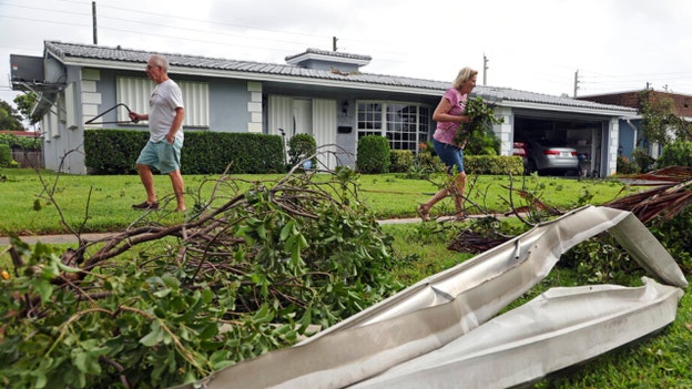
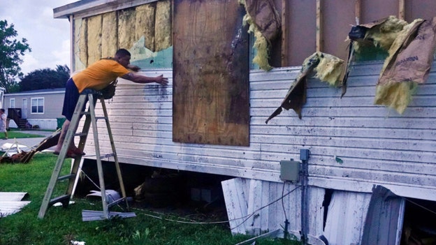
Florida apartment building sways in Hurricane Ian's path: 'Unbelievable'
In a video obtained by Fox News Digital, an apartment on the 27th floor sways due to Hurricane Ian's force in Fort Meyers, Florida.
High winds in Naples, Florida as Hurricane Ian makes landfall
High winds and rain from Hurricane Ian can be seen battering homes and trees in Naples, Florida.
Florida Gov. Ron DeSantis holds briefing as Hurricane Ian sweeps through state
Boat adrift as Hurricane Ian makes landfall in Florida
In Fort Myers, Florida, a boat was stranded off the coast of Florida as Hurricane Ian made landfall.
Hurricane Ian: Seminole County Office of Emergency Management provides update
Hurricane Ian moving at crawl pace, prompting concern of flooding, delayed rescues
Hurricane Ian, which slammed Florida’s southwest coast with Category 4 force Wednesday afternoon, is moving a pace of roughly 9 miles per hour.
Officials are concerned that the storm’s relatively slow surge could lead to greater rainfall, which cause serious flooding and delay rescues.
Per FOX Weather, Hurricane Ian is a "worst-case scenario" for Southwest Florida, and the slow forward progress of the storm will add to the height of the surge.
Hurricane Ian tied for Florida's 4th-strongest landfall
Hurricane Ian, which made landfall in southwest Florida as a Category 4 storm Wednesday afternoon, is now tied for the state's 4th-strongest landfall on record, per FOX Weather.
South Carolina Gov. McMaster declares state of emergency as Hurricane Ian makes landfall in Florida
South Carolina Gov. Henry McMaster declared a state of emergency Wednesday just moments after Hurricane Ian made landfall in southwest Florida with Category 4 force.
Hurricane Ian knocks out power to police's emergency operations center at Marco Island
Marco Island Police Department says Hurricane Ian has knocked out power to its Operations center, including non-emergency phones and primary and secondary Wi-Fi.
Hurricane Ian forces Waffle House locations in Florida to close
American diner chain Waffle House is shuttering multiple locations in Florida as Hurricane Ian comes ashore.
The beloved restaurant franchise is known for staying open even during severe weather. The decision to close ahead of the hurricane's landfall has been seen as a bad omen under the so-called Waffle House Index.
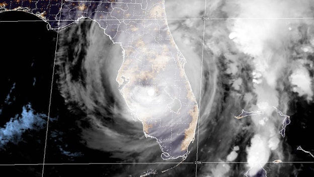
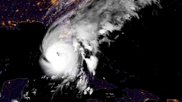
Ian makes landfall in Florida as Category 4 hurricane, 2 million without power
Hurricane Ian has made landfall in Southwest Florida with Category 4 force, weather officials say.
The eye of Ian made landfall along the southwestern coast of Florida near Cayo Costa just after 3 p.m. EST, NOAA Doppler radar imagery shows.
By Wednesday evening, the storm was downgraded to a Category 2, but 2 million people remained without power.
Data from an Air Force Reserve reconnaissance aircraft indicate that Ian's maximum sustained winds were estimated to be near 150 mph.
The National Hurricane Center says the minimum pressure from Air Force Reconnaissance Hurricane Hunters was 940 mb.
Hurricane Ian power outages in Florida surge to 2 million as eyewall moves on shore
Floridians are beginning to lose power, with outages at 2 million as the Category 4 Hurricane Ian made landfall Wednesday.
Just hours earlier – around 5 a.m. – reported outages totaled approximately 35,000, according to PowerOutage.us.
Disney World tells hotel guests to shelter in place

Disney World has asked all hotel guests to shelter in place as the powerful Hurricane Ian approaches Florida.
The entertainment giant said its theme parks and waters parks would be temporarily closed Wednesday, Sept. 28 and Thursday, Sept. 29.
"Partially used multi-day theme park tickets with a validity window impacted by closure due to Hurricane Ian will be automatically extended to allow use of the remaining unused ticket days through Sept. 30, 2023," Disney World Said in a statement. "In order to enter a park, both a park reservation and valid ticket for the same park on the same date are required."
Jean-Pierre says Florida will have ‘full force’ of federal government in Hurricane Ian response
White House Press Secretary Karine Jean-Pierre on Wednesday reiterated the Biden administration’s pledge that the people of Florida “will have the full force of the federal government and resources” in its response to Hurricane Ian.
“The president wanted to relay that his prayers are with the people of Florida and that Florida will have the full force of the federal government,” Jean-Pierre said of the president’s phone call with Florida Gov. Ron DeSantis.
“And so that will continue. We will continue to see that partnership. And again, we will have the full force of the federal government and resources to the people of Florida.”
She added that the Biden administration is “surging” its efforts and “making sure that we are there for the people of Florida.”
“We will continue to do that. You will hear again directly from this president tomorrow when he visits FEMA to get to get an update,” she said. “But again, this president has been all hands-on deck at this moment.”
Border Patrol rescues 4 Cuban migrants after boat sinks off Florida coast as Hurricane wallops state
U.S. Border Patrol agents along with support from the Monroe County Sheriff's Office responded to a migrant landing in Stock Island, Florida. USBP says four Cuban migrants swam to shore after their vessel sank due to "inclement weather." USCG Southeast are searching for 23 individuals.
Biden to visit FEMA HQ Thursday for briefing on Hurricane Ian
President Biden will visit FEMA Headquarters Thursday to receive a briefing on federal response efforts for Hurricane Ian, White House Press Secretary Karine Jean-Pierre said Wednesday.
"Already we have deployed significant federal resources to the region to help prepare for a hurricane. We have more than thirteen hundred federal response workers on the ground in Florida," she said.
23 Cuban migrants missing after boat sinks due to 'inclement weather,' border official says
In a tweet on Wednesday, the U.S. Border Patrol's Miami Sector chief patrol agent, Walter N. Slosar, said that border patrol agents and the Monroe County Sheriff's Office had responded to a migrant landing in Stock Island, Florida.
"[Four] Cuban migrants swam to shore after their vessel sank due to inclement weather," he explained," adding that the U.S. Coast Guard's 7th District had initiated a search and rescue operation to look for 23 individuals.
The medical condition of the four migrants was not immediately clear.
On Tuesday, Slosar said that seven migrants from Cuba had been taken into custody after making landfall at Pompano Beach.
"Do not risk your life by attempting this journey at sea. Storm surge along with king tide can create treacherous sea conditions even after a storm passes," he urged.
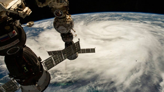
Air Force hurricane hunters inside Ian's eye capture eerie calm, blue skies
DeSantis: 200K power outages is 'drop in the bucket' compared to what's coming

Gov. Ron DeSantis said in a Wednesday press briefing that the more than 200,000 power outages reported in the state of Florida were nothing more than a "a drop in the bucket for what's going to happen" as Hurricane Ian makes landfall.
"There's going to be widespread power outages, particularly in southwest Florida," he explained, adding that more than 100 portable cell towers were ready to be deployed once it is safe to do so.
Tracker PowerOutage.US showed that there were more than 304,000 customers without power on Wednesday afternoon.
There are now more than 42,000 linemen and other personnel ready to restore power in 30 areas across the state.
The governor told residents to avoid standing water and downed trees and powerlines, to not use a generator indoors and to stay out of the way of emergency crews.
"There's going to be a lot going on in the immediate aftermath and a lot of peoples' safety depends on that," he said.
DeSantis said that the Secretary of Defense had approved Florida's request for dual status of its National Guard forces under Title 10 to provide additional forces and that a major disaster declaration for all 67 counties would be submitted, requesting that the federal government reimburse 100% of the upfront costs for the first 60 days.
"So, the effects of this are going to be broad, and we appreciate the Biden administration's consideration for the people of Florida during this time of need," the governor added.
He said there would be a massive effort as soon as the storm passes southwest Florida to get out, recon the area and identify where rescue services are necessary.
DeSantis said that while the state has everything it needs in terms of immediate response needs, thousands of Floridians will need help rebuilding.
"You know, this is going to be a rough patch here for the rest of today and into tomorrow. But, you know, we understand how significant this storm is."
He said it will be one of the storms that people always remember when they think about southwest Florida.
FDEM Director Kevin Guthrie asked that anyone who is sheltering in place in the path of the storm visit floridadisaster.org/info to fill out a "shelter-in-place" survey.
He also asked residents to understand that 911 services may not be able to reach certain areas as Hurricane Ian hits.
"Please do everything you can right now to stay safe," Guthrie instructed.
How much can Disney lose as a result of Hurricane Ian-prompted closures?
Hurricane Ian has closed Walt Disney World Resort for Wednesday and Thursday as the storm makes its way across Florida. That leaves some wondering how much the company may lose in revenue as a result.
"In fiscal 2022's first quarter, Disney's parks, experiences and products revenue was $7.234 billion. Over 90 days, that works out to about $80.38 million per day," Market Realist reports.
Last month, The New York Times reported the company had a strong demand for theme-park vacations, despite economists' worries about an inflation-led downturn in consumer spending.
"Economists have long watched Disney’s theme parks as informal barometers of consumer confidence. Historically, when budgets get tight, families cut back on trips to Disney World in Florida and Disneyland in California. That does not appear to be happening: Disney Parks, Experiences and Products reported quarterly revenue of $7.4 billion, up from $4.3 billion a year earlier, and an operating profit of $2.2 billion, up from $356 million," the report reads.
The company's parks across the world temporarily closed their doors due to the coronavirus pandemic.
Fox Business' Pilar Arias contributed to this report.
Florida Disaster Fund activated in preparation for Hurricane Ian

First Lady Casey DeSantis announced the activation of the Florida Disaster Fund to support Florida’s communities impacted by Hurricane Ian.
“The Governor and I are thankful for the graciousness of those looking to assist Florida’s communities in their time of need,” DeSantis said in a release. “I am pleased to announce that Volunteer Florida has activated the Florida Disaster Fund so that people can donate directly to those affected by Hurricane Ian. We greatly appreciate the kindness and generosity of organizations and individuals from across the country looking to support Floridians, thank you.”
The Florida Disaster Fund is the state of Florida's official private fund established to provide financial assistance to communities as they respond to and recover from times of emergency or disaster.
In partnership with public, private, and other non-governmental organizations, the Florida Disaster Fund supports response and recovery activities.
Donations to the disaster fund may be made at www.floridadisasterfund.org or by check.
PA governor announces deployment task force to SC to support Hurricane Ian response

Pennsylvania Gov. Tom Wolf announced that 45 members and support personnel from Pennsylvania-Task Force 1 would deploy to South Carolina later Wednesday to support response operations in the aftermath of Hurricane Ian.
“Millions of people in the southeastern United States will have a long road ahead of them in terms of response and recovery,” Wolf said in a release. “We are in close contact with emergency management partners in those states and will remain ready and willing to assist however they need us in the weeks and months ahead.”
The governor said that the two members of PA Task Force 1 (PATF-1) who deployed to Puerto Rico ahead of Hurricane Fiona were reassigned to Florida in advance of Hurricane Ian.
They are part of a federal Incident Support Team that will work with Florida emergency management and response personnel to augment operations.
PATF-1 is one of 28 teams that are part of the National Urban Search and Rescue Response System and is a federal resource that can quickly be mobilized to deploy to incidents anywhere in the country.
The team is sponsored by the Philadelphia Fire Department.
Gov. Wolf said the Pennsylvania Emergency Management Agency is also monitoring the Emergency Management Assistance Compact (EMAC) system for requests for assistance.
According to the National Weather Service, at this time Hurricane Ian is unlikely to bring significant storm conditions to Pennsylvania, although rain from the system could arrive across southern parts of the state over the weekend.
Hurricane Ian eyewall moving onshore at Sanibel and Captiva Islands
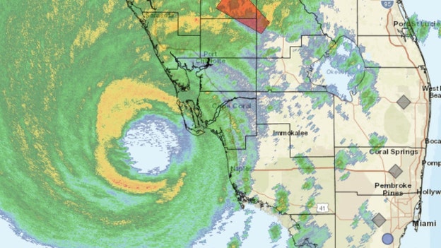
The National Hurricane Center said that the eyewall of Hurricane Ian was moving onshore at Sanibel and Captiva Islands.
In an update, Acting NHC Director Jamie Rhome said that extreme wind warnings would be in place for the Sanibel, Cape Corral and Boca Grande areas.
An extreme wind warning is in effect for Englewood, Rotonda, and Grove City until until 2 p.m. EDT.
"Treat these imminent extreme winds as if a tornado was approaching and move immediately to an interior room or shelter NOW!" the National Weather Service in Tampa Bay wrote in a tweet.
Rhome said residents in this areas should not venture outside at all and brace for impact.
"You really have to get into the interior of your house and ride this part out," he said.
Rhome pointed out that rain bands were starting to impact Tampa and the I-4 corridor
Rain bands starting to impact Tampa, I-4 corridor.
"Conditions are going to start going downhill today. So, get wherever you need to be up along the I-4 corridor and stay there," he advised, calling the hurricane a "very devastating event."
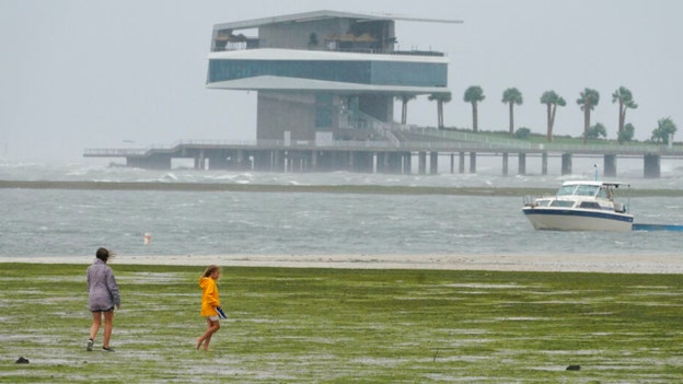
Naples, Florida sees record storm surge from Hurricane Ian
Fox Weather reported early Wednesday afternoon that Naples had recorded historic surge from Hurricane Ian.
The latest storm surge is up to 6 feet, with water is steadily rising.
The previous record to 4.25 feet feet was set during Hurricane Irma in 2017.
The forecast calls for 8 to 12 feet of storm surge there and Fox Weather said that the worst is yet to come.
A weather sensor in the area just recorded a 112 mph wind gust at the Naples Grande Beach Resort.
In a release, FEMA Administrator Deanne Criswell urged anyone in the path to heed warnings of local officials.
Criswell said the agency had established a search and rescue coordination group in Miami that includes Urban Search and Rescue teams, Coast Guard, Department of Defense, Department of the Interior and local Florida rescue teams.
The National Hurricane Center issued hurricane and tropical storm warnings for much of Florida’s coastline.
What is a Cat. 5 hurricane?: What hurricane categories mean
Hurricane Ian is near Category 5 status as Floridians prepare for landfall Wednesday.
What is a Category 5 hurricane? What do hurricane categories mean? That is where the National Hurricane Center comes in.
The Saffir-Simpson Hurricane Wind Scale is a 1 to 5 rating based only on a hurricane's maximum sustained wind speed. The scale does not take into account other potentially deadly hazards such as storm surge, rainfall flooding and tornadoes.
Category 1 hurricane (74-95 mph): Very dangerous winds will produce some damage
Well-constructed frame homes could have home damage to roofs, shingles, vinyl siding and gutters. Large branches of trees will snap, and shallowly rooted trees may be toppled. Extensive damage to power lines and poles likely will result in power outages that could last a few to several days.
Category 2 hurricane (96-110 mph): Extremely dangerous winds will cause extensive damage
More property damage will occur on well-constructed frame homes could sustain major roof and siding damage. Many shallowly rooted trees will be snapped or uprooted and block numerous roads. Near-total power loss is expected, with outages that could last from several days to weeks.
Category 3 hurricane (111-129 mph): Devastating damage will occur
Well-built framed homes may incur major damage or removal of roof decking and gable ends from the wind. Many trees will be snapped or uprooted, blocking numerous roads. Electricity and water will be unavailable for several days to weeks after the storm passes.
Category 4 hurricane (130-156 mph): Catastrophic damage will occur
Well-built framed homes can sustain severe damage, with loss of most of the roof structure and/or some exterior walls. Most trees will be snapped or uprooted and power poles downed. Fallen trees and power poles will isolate residential areas. Power outages will last weeks to possibly months. Most of the area will be uninhabitable for weeks or months.
Category 5 hurricane (157 mph or higher): Catastrophic damage will occur
The highest hurricane category – A large percentage of framed homes will be destroyed, with total roof failure and wall collapse. Fallen trees and power poles will isolate residential areas. Power outages will last for weeks to possibly months. Most of the area will be uninhabitable for weeks or months.
Fox News' Pilar Arias contributed to this report.
'Extremely dangerous' eyewall of Hurricane Ian moving onshore
The National Hurricane Center said that extremely dangerous eyewall of Hurricane Ian was moving onshore.
The Category 4 storm, with maximum sustained winds still reported at 155 miles per hour, will cause castrastophic storm surge, winds and flooding in the Florida peninsula "soon."
Ian was located about 45 miles west-northwest of Naples, Florida.
Additional hurricane, tropical storm and storm surge warnings were issued as the hurricane moved toward the north-northeast near 9 mph.
A reduction in forward speed is forecast and Ian could be near hurricane strength when it moves over the eastern coast on Thursday.
Florida Gov. Ron DeSantis said Ian could be a Category 5 storm by the time it hits his state.
"And, we understand this is not just a 48 hour ordeal. This is going to be something that is going to be there for days and weeks and months. And, unfortunately, in some circumstances, even years," he remarked.
Speaking at a White House event, President Biden said he had spoken with DeSantis and that his team had been in constant contact with him from the beginning.
"I made it clear to governor and the mayors that the federal government is ready to help in every single way possible," he said, adding that the danger is "real."
Biden said the federal government would be there to help rebuild.
Charlotte County suspends emergency response services
Charlotte County Fire & EMS has suspended emergency response to calls for service due to hazardous weather conditions.
"@CCSOFLSheriff & City of Punta Gorda first responders have suspended emergency response to calls for service due to hazardous weather conditions," the department said in a Wednesday tweet.
Charlotte County is located on the southwestern coast of Florida between Venice and Fort Myers.
In a morning press conference, Emergency Management Director Patrick Fuller announced that while 911 will remain operational, authorities are no longer able to respond.
"Over the next several hours of which we will begin experiencing the most extreme effects of Hurricane Ian, we can expect to see storm surge to life-threatening levels into several of our hurricane evacuation zones in Charlotte County," he explained.
Fuller encouraged county residents to hunker down and await the passage of the storm and not to venture out into dangerous conditions when it does pass.
The National Hurricane Center says catastrophic storm surge inundation of 12 to 18 feet above ground level is expected somewhere between Englewood to Bonita Beach, including Charlotte Harbor.
Catastrophic wind damage is also beginning.
National Weather Service director on Hurricane Ian: A 'historic' event
Speaking at a FEMA presser, National Weather Service Director Ken Graham said that Hurricane Ian would be a "historic" event.
"Well, I wish this wasn't a forecast that I had to deliver ... I wish this wasn't a forecast that's about to come true," he told reporters. "So, this is a devastating storm for parts of Florida. Not just on the southwest coast, but also inland associated with some of these impacts."
Graham said Ian would be a storm the U.S. would talk about for many years to come.
Squalls are already over Florida as the Category 4 hurricane approaches and Graham said that NOAA was throwing everything at it.
He noted that it's going to take 24 hours from landfall for the slow-moving storm to make it to the other side of the state and that some places are going to get two feet of rain in addition to life-threatening storm surge.
Graham added that there will be a devastating amount of damage around the eyewall, with 90% of tornadoes coming around that right-front quadrant.
The director also urged residents to be careful with generators and after the storm has passed.
According to Fox Weather, landfall is expected between Cape Coral and Sarasota, between 2 and 4 p.m. EDT.
Fox Weather hurricane specialist: Ian will be a 'worst-case scenario' for Southwest Florida
FOX Weather Hurricane Specialist Bryan Norcross said that Hurricane Ian's forecast track appears to be a "worst-case scenario" for Southwest Florida.
According to Norcross, the category of the nearly Category 5 hurricane is irrelevant and that the large diameter of the strong winds will cause the storm surge to be about "as high as it can be."
Waterways where reverse surge occurs are particularly susceptible to giant storm surge when the water comes back.
Photos shared from Venice and Tampa showed water levels receding.
Storm surge will also require evacuations in north Florida.
Where winds of Category 3 or 4 strength occur, there will be massive damage to structures and a corridor of intense rain is still expected across the state.
Gusts will be more of a factor inland than sustained winds.
Suspected tornado flips planes at Florida airport as Hurricane Ian closes in: report

Damage occurred at a Broward County, Florida, airport following a suspected tornado.
According to FOX 35, trees were downed and several small planes were flipped at North Perry Airport in Pembroke Pines as Hurricane Ian continued to approach.
The station said that more than 15 planes were reportedly damaged and that there were no reports of any injuries.
Some hangars were said to be damaged, as well.
The National Weather Service office in Miami issued tornado warnings in the county through the evening.
One user replied to a tweet from the office calling for reports with an image of the airport.
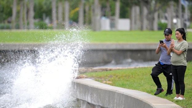
Stunning images show receding waters ahead of Hurricane Ian's landfall
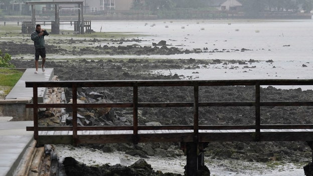
The National Weather Service's Tampa Bay office and the Tampa Police Department shared images of receding water as Hurricane Ian draws near.
"IMPORTANT NOTE: The water WILL come back," the NWS tweeted alongside images shared from Venice, Fla. "Please do not attempt to walk there or any other location with receding water."
Tampa police noted that evacuations are still in effect for Zones A and B.
Clearwater, Fla. reduced drinking water service
The city of Clearwater, Florida, said Wednesday that it had proactively reduced drinking water service on Clearwater Beach.
However, it did not shut down the lift stations that service the beach.
"The water is safe to drink, and wastewater return is currently operating," the city said in a tweet.
The city, which is located in Pinellas County, has declared a state of emergency due to Hurricane Ian.
Hurricane Ian evacuation: What to pack
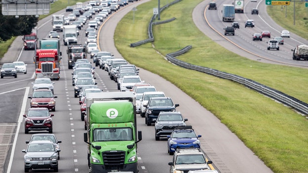
Hurricane Ian's approach has resulted in mandatory and voluntary evacuations along the west coast of Florida.
Residents can check their evacuation status and flood zone risks on county websites, official social media accounts and FloridaDisaster.org’s "Know Your Zone" map, which is run by the Florida Division of Emergency Management.
Hurricane and disaster preparation experts recommend having basic emergency supplies and "go bags" ready before severe weather or natural hazard arrives.
The U.S. Department of State recommends packing six item categories in a go bag: money, medical items, personal belongings, food and water, documentation and optional weather gear.
Money
- ATM cars, credit cards
- Checkbook
- Multiple currencies if evacuating from a foreign port
- Safe deposit keyes
- Government travel card if applicable to eligible government workers
Medical Items
- Medical and dental records
- Immunization cards
- Glasses and contact lenses (with carrying case and cleaning solution)
- Prescription medications
- Over-the-counter medications
- Small first aid kit
Personal Belongings
- Clothing
- Pet items
- Small toiletry kit
- Chargers for all electronics
- Toys and games
Food and water
- Snacks
- Water
Documentation
- Passport(s) and visas if evacuating from a foreign port
- Marriage, birth, adoption and naturalization certificates
- State Department ID (applicable to government workers only)
- Driver’s license and/or state ID- Auto insurance policies, registrations and title if applicable
- Power of attorney and will
- School records
- Pet records
- Household effects inventory
Optional Weather Gear
- Rain gear
- Insect repellant
- Tarp
Click here for more.
Fox News' Cortney Moore contributed to this report.
Storm surge from Ian could be as high as 18 feet, forecasters say
The National Hurricane Center has increased peak storm surge inundation amounts.
Storm surge is now forecast to be as high as 18 feet from Englewood to Bonita Beach and in Charlotte Harbor.
In 2005, the center shows Hurricane Katrina had storm surge flooding of 25 to 28 feet above normal tide level along parts of the Mississippi coast, with storm surge flooding of 10 to 20 feet above normal tide levels along the southeastern Louisiana coast.
Florida county Sheriff Grady Judd on Hurricane Ian: Impact will be 'catastrophic hit'
Polk County Sheriff Grady Judd told "Fox & Friends" on Wednesday that Hurricane Ian's impact would be a "catastrophic hit" to the southwestern coast on Florida.
"It is a massive storm, in size. It's going to move slow. There's going to be high winds and a lot of rain," he explained.
Judd instructed residents to pay attention to what the experts say ahead of landfall.
He told people who weren't evacuating to hunker down and do the best they can.
"If you get scared, we don't come get you in the middle of the storm. We're all missions to save lives at that moment in time. And, that's what our deputies will be doing," Judd explained, noting that people appeared to largely be heeding warnings.
"So we feel that we are as prepared as it's possible," he added.
National Hurricane Center: Time 'quickly running out' for southwestern Florida
The National Hurricane Center said that time is quickly running out for southwestern Florida residents to rush preparations to completion as Hurricane Ian nears.
Tropical-storm-force winds are already beginning to affect the coast.
Conditions are forecast to rapidly deteriorate and catastrophic wind damage is expected.
While more than 2.5 million people are under mandatory evacuation orders, no one is forced to flee by law.
Gov. Ron DeSantis said that National Guard troops and urban search and rescue teams were on standby.
"The assets we have are unprecedented in the state's history and, unfortunately, they'll need to be deployed," he told reporters.
Parts of Flagler County under evacuation; residents urged to leave by noon
Parts of Florida's Flagler County are now under an evacuation order.
According to county authorities, evacuations are effective at 1 p.m. EDT, with people being told to leave as soon as possible.
"We urge those who are going to stay with relatives, friends or at hotels to complete their evacuation by noon,” said Emergency Management Director Jonathan Lord. “This will clear that traffic by 1 p.m., when those who are going to shelters need to leave. They will open at 1 p.m.”
The evacuation is in effect for residents and visitors in mobile homes and RVs countywide, Zone A, the barrier island from from Flagler Beach to Marineland, low-lying areas in Zone B and non-elevated homes in the low-lying areas of Zone F.
Residents and a maximum of four pets are encouraged to arrive at shelters at 4 p.m. and bring their own bedding and supplies.
No snakes, reptiles or farm animals and livestock are allowed.
No drop-offs of residents with special medical needs are allowed. A family member or caregiver should stay with the individual.
The shelter locations are:
Bunnell Elementary – General Population and Pets 305 N. Palmetto Street, Bunnell
Rymfire Elementary – Special Needs 1425 Rymfire Drive, Palm Coast
Hurricane Ian forces closure of Sunshine Skyway Bridge
In a media alert, the Florida Highway Patrol said that it had closed the Sunshine Skyway Bridge in both directions.
Winds there, the agency said, are now ranging between 50 and 60 miles per hour, as Hurricane Ian approaches.
"The Bridge will remain closed until the storm passes and the inclement weather subsides," FHP said.
If motorists need to travel on Wednesday and Thursday, they should confirm the availability of their route by monitoring Florida Highway Patrol Current Traffic Incidents or Florida 511.
Florida power outages reported for nearly 270K as Hurricane Ian approaches

The outage tracker PowerOutage.US showed Wednesday morning that there were 269,839 customers without power in Florida.
Ahead of Hurricane Ian's landfall, Gov. Ron DeSantis told reporters that there are more than 30,000 linemen staged and ready for power restoration efforts.
That total includes linemen across all of Florida's major utilities.
"And, a lot of these linemen are coming from out of state," he explained. "So, this is a major, major effort."
"Of course, the storm has to pass and [there] needs to be the ability for them to get in and access what they need to access. But, that's going to be a priority," DeSantis noted.
Gov. Ron DeSantis, Florida officials warn that the time for evacuation is over

Gov. Ron DeSantis said Wednesday that much of southern Florida is already experiencing impacts from Hurricane Ian.
The governor told reporters in a briefing that current track has the storm making landfall in Charlotte County, with the highest risk areas ranging from Collier County and up to Sarasota County.
"If you are in any of those counties, it's no longer possibly to safety evacuate. It's time to hunker down and prepare for this storm," he urged.
Those out on the roads should get to a safe place as soon as possible.
DeSantis noted that there are bridges closed and that there are more than 200 shelters open in just the southwestern region of the state.
Residents who are hunkering down should wait to go outside until the storm has passed and be cautious afterward.
The governor said Ian could make landfall as a Category 5 hurricane.
"So, this is a major, major storm," he stated, adding that the strengthening of the storm overnight has been "significant."
DeSantis said FDEM Director Kevin Guthrie had requested additional airlift hoists and highwater vehicles from the Department of Defense in coordination with FEMA and that the Department of Transportation also has 1,200 personnel on standby to perform cut and toss operations.
The governor said 26 states have sent support ahead of the storm.
"This is going to be a nasty, nasty day, two days ... So, this is going to be a rough stretch," DeSantis said.
Florida Publix grocery stores close ahead of Hurricane Ian

Floridians who need last-minute groceries and supplies ahead of Hurricane Ian may need to move quickly.
More than 400 Publix grocery stores are under "modified hours" as a result of the storm.
Some locations in central Florida are already closed until Friday morning, while others close early on Wednesday.
Officials anticipate the stores will reopen on Friday, Sept. 30.
Hurricane Ian may spike food prices. Publix said it has increased purchases on items such as bread, water, batteries and canned goods.
Fox Business' Pilar Arias contributed to this report.
Rapidly intensifying Hurricane Ian forecast to cause catastrophic storm surge, winds and flooding
The National Hurricane Center said Wednesday that Hurricane Ian would cause catastrophic storm surge, winds and flooding in the Florida peninsula.
The storm was located about 65 miles west-southwest of Naples, Fla., with maximum sustained winds at 155 miles per hour.
A hurricane warning was in effect for Chokoloskee to Anclote River and Dry Tortugas.
A storm surge warning was in effect for Suwannee River southward to Flamingo, Tampa Bay, the lower Florida Keys, Dry Tortugas, St. Johns River and the Flagler/Volusia Line to the mouth of the St. Mary's River.
The combination of storm surge and tide will cause normally dry areas near the coast to be flooded by waters moving inland.
From Englewood to Bonita Beach, the water could reach from 12 to 16 feet.
A tropical storm warning is in effect for all of the Florida Keys, Indian Pass to the Anclote River, Flamingo to South Santee River and Chokoloskee, Lake Okeechobee and Florida Bay.
Ian is moving toward the north-northeast near nine mph.
It is expected to produce rainfall of up to 18 inches and tornadoes are possibly through Wednesday evening across central and southern Florida.
Miami-Dade County temporarily suspends transit service
Miami-Dade County decided early Wednesday morning to suspend countywide transit services as Hurricane Ian approaches Florida.
In a release, the county said Metrobus, Metrorain, Metromover and Special Transportation Services were impacted started at 1 a.m. EDT.
"Service will be suspended until further notice," it said.
Riders should visit miamidade.gov/alerts for updates, with more coming as conditions develop.
Hurricane Ian nearly a Category 5 storm
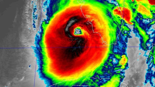
Hurricane Ian was rapidly intensifying early Wednesday.
The National Hurricane Center said in an update that recent data from NOAA Hurricane Hunters indicates the storm has maximum sustained winds of up to 155 miles per hour.
A Category 5 hurricane on the Saffir-Simpson Hurricane Wind Scale has winds of 157 mph or higher.
Conditions 'rapidly deteriorating' as Hurricane Ian moves toward Florida
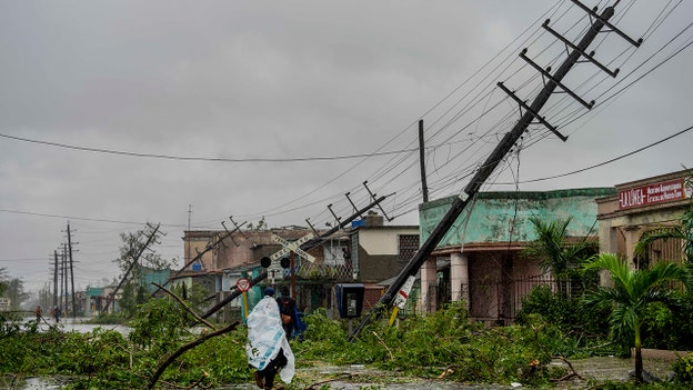
Hurricane Ian's winds and rain continue to intensify a day after the storm battered the western tip of Cuba.
The National Hurricane Center said that conditions were "rapidly deteriorating" along the southwestern Florida coast.
The hurricane has prompted warnings of dangerous storm surge along the Gulf Coast.
Forecasters said the storm surge could reach up to 12 feet if it peaks at high tide and rainfall near where Ian makes landfall could top 18 inches.
At least 2.5 million residents have been ordered to evacuate.
Warnings were also issued for isolated tornadoes.
Parts of Georgia and South Caroline could also see flooding rains and coastal surge into the weekend.
Georgia Gov. Brian Kemp declared a state of emergency.
The governor ordered 500 National Guard members to standby.
The Associated Press contributed to this report.
Hurricane Ian disrupts major cruise line itineraries

Hurricane Ian is disrupting the itineraries of major cruise lines.
In an emailed statement to FOX Business Digital, Royal Caribbean Group said that the safety of its guests, crew and communities is the company's top priority.
"Royal Caribbean Group is closely monitoring the progression of Hurricane Ian, and we are making adjustments to some of our Caribbean routes to ensure the comfort and safety of our guests and crew. Guests on impacted sailings will be notified of any changes," it said.
Allure of the Seas will skip a call at Roatan, Honduras, which was scheduled for Tuesday. The ship is on a six-night voyage from Fort Lauderdale, Florida.
Mariner of the Seas skipped a call for Labadee, Haiti, and is at sea. The ship is on a five-night voyage from Port Canaveral.
Liberty of the Seas is skipping a call at Cozumel, Mexico. The ship is on a seven-night cruise from Galveston, Texas.
Lastly, Celebrity Infinity has replaced calls to Belize and Cozumel with visits to Nassau and Labadee.
The ship is on a seven-night sailing that began from Fort Lauderdale on Sept. 24.Norwegian Cruise Line has also had to recalibrate because of the storm.
"The safety and security of our guests and crew is always our number one priority," a spokesperson told FOX Business Digital.
On Tuesday, a Norwegian Sky ship would make port in San Juan, Puerto Rico, instead of George Town in Grand Cayman. Ports and arrival and departure times were also changed on from Sept. 28 through Oct. 1.
"As the safety of our guests and crew is our number one priority, Carnival Cruise Line's Fleet Operations Center in Miami is continuing to monitor Hurricane Ian and its potential impact on itineraries," a spokesperson for Carnival Cruise Line said in an emailed statement.
Changes were made to the itineraries of Carnival Paradise, Carnival Elation, Carnival Ecstasy and Carnival Glory.
FOX Business' request for comment from Celebrity and MSC Cruises was not immediately returned.
Cat. 4 Hurricane Ian expected to cause life-threatening storm surge, catastrophic flooding and winds
In a 5 a.m. EDT update, the National Hurricane Center said that the center of Hurricane Ian was located about 125 kilometers west-southwest of Naples, Florida.
Hurricane hunters found that the storm had strengthened into an extremely dangerous Category 4 hurricane.
Maximum sustained winds have increased to near 140 miles per hour, with higher gusts.
The agency warned that it was expected to cause life-threatening storm surge and catastrophic winds and flooding in the Florida peninsula.
Ian was moving toward the north-northeast near 10 mph, with a reduction in speed forecast on Wednesday before turning north on Thursday.
The center of the hurricane is projected to approach the western coast of the Sunshine State and move onshore later in the day.
On Wednesday evening and Thursday morning, the center will move over central Florida, before it emerges over the western Atlantic by late Thursday.
Some fluctuations in intensity are possible, the center noted, before Ian reaches the coast and weakening is expected after landfall.
Hurricane Ian officially a Category 4
Hurricane Ian has intensified to a Category 4.
Hurricane Ian set to become first Category 4+ to make landfall in Florida since 2018
Hurricane Ian is continuing to intensify off the coast of Florida and has upgraded to a Category 4 ahead of its expected landfall Wednesday afternoon.
The severe storm strengthened to a Category 4 early Wednesday morning. It is about 85 miles off the southwest coast of Florida, which is already experiencing high winds, heavy rain and flooding.
It is the first Category 4 or higher storm since Hurricane Michael made landfall in Florida in 2018. Michael made landfall as a Category 5. Hurricane Irma (2017) made landfall as a Category 4.
"Hurricane Ian is expected to bring catastrophic flooding and life-threatening storm surge to large portions of the west coast," Florida Gov. Ron DeSantis said in a statement. "Listen to your local emergency officials and heed all evacuation orders to keep your families safe."
Ian strengthened to a Category 2 on Monday before it made landfall on Cuba as a Category 3.
The Associated Press contributed to this report.
Hurricane Ian within 90 mi SW of Naples, Florida: National Hurricane Center
Cuban thermoelectric plants have started up: Energy Ministry
Two Cuban thermoelectric plants disabled by Hurricane Ian have started up, the Cuban Ministry of Energy announced early Wednesday morning.
The two Cuban plants were at "0 electricity generation" after the severe storm decimated the island and left its 11 millions residents without power.
Minister of Energy Liván Arronte said the government will offer electrical service to people but its priority "is to reach the large thermoelectric plants to begin the start-up process."
Electric Union technical director Lázaro Guerra said electro-energy systems have been restored in three regions in the country.
National Weather Service issues storm surge, flooding warnings across Florida
The National Weather Service (NWS) has issued warnings across the state of Florida as Hurricane Ian is set to make landfall on Wednesday.
The government service has warned residents of life-threatening storm surges, devastating wind damage, and considerable flooding in the coming days.
"Life-threatening storm surge is likely with the highest risk from Naples to Sarasota," the NWS said. "Devastating wind damage is expected near the core of Ian. Considerable flooding is expected with widespread, prolonged moderate to major river flooding expected across central Florida. Tornadoes are possible in central and south Florida."
Flood watches, advisories or warnings have been issued in Baker, Bradford, Central Marion, Coastal Duval, Coastal Flagler, Coastal Nassau, Coastal St. Johns, Eastern Alachua, Eastern Clay, Eastern Marion, Eastern Putnam, Gilchrist, Glades, Hendry, Inland Flagler, Inland Nassau, Inland St. Johns, Monroe Keys, Palm Beach, South Central Duval, Trout River, Union, Western Alachua, Western Clay, Western Duval, Western Marion, Western Putnam and other areas.
Gov. DeSantis braces for Hurricane Ian's landfall on Florida coast
Florida Gov. Ron DeSantis spoke with Sean Hannity about the "massive amount of water and surge" expected when Hurricane Ian makes landfall in the Sunshine State.
"We have a saying down here in Florida, you hide from the wind, but you run from the water," DeSantis said to Hannity.
Miami-Dade County suspends countywide transit services
Miami-Dade County has suspended countywide transit services as heavy winds and torrential rain from Hurricane Ian has impacted the area.
A press release from the Emergency Operations Center (EOC) said the transit suspension includes Metrobus, Metrorail, Metromover and Special Transportation Services.
The service is suspended until further notice, according to the EOC.
On Friday, Sept. 23, Mayor Daniella Levine Cava declared a Local State of Emergency and updated the guidance on Tuesday, Sept. 27, as the Category 3 Hurricane Ian continues to path through the Gulf of Mexico and toward Florida.
As of the update, all of Miami-Dade is now under a tropical storm warning.
“Our top concern right now is the safety of our residents and visitors,” said Mayor Levine Cava. “Miami-Dade County will avoid direct impact from Hurricane Ian, but we are actively experiencing heavy rain and wind and expect flooding. We continue to remind residents to remain vigilant for updates on the weather conditions, and to stay off the roads if possible as we anticipate possible tropical storm force winds beginning early Wednesday.”
She also announced non-essential county services will be suspended on Wednesday, September 28 and Thursday, September 29.
Dozens of tornado warnings issued across Florida
Tornadoes spawned from Hurricane Ian appeared across South Florida Tuesday evening, prompting weather officials to warn residents.
Multiple tornado warnings were issued in Pembroke Pines, Palm Beach, Broward County, and Hollywood, Florida.
The National Weather Service warned of a damaging tornado in Broward County around 7:30 p.m. ET.
Hurricane Ian will continue to enhance the tornado risk for South Florida through Wednesday, and for other areas as the major storm is expected to make landfall that afternoon. It is projected to spend several days traveling across the state and will depart into the Atlantic on Friday.
Fox Weather's Heather Brinkmann contributed to this report.
Ian could become a catastrophic Category 4; millions of Florida residents ordered to evacuate
Florida officials have urged residents to board up their homes, relocate precious belongings to upper floors and load up on cash and fuel ahead of Hurricane Ian making landfall, as the monstrous storm nears the state.
The storm already knocked out power to all of Cuba and left 11 million people were left without power. And, millions of Floridians are expected to face a similar fate.
At least 2.5 million Florida residents were ordered to evacuate in anticipation of the Category 3 hurricane, which continues to intensify, and its storm surge, high winds and flooding rains are already impacting south and central areas of the state.
The U.S. National Hurricane Center predicted Ian could become a catastrophic Category 4 hurricane with winds up to 130 mph (209 kph) before making landfall on Wednesday afternoon.
“It is a big storm, it is going to kick up a lot of water as it comes in,” Florida Gov. Ron DeSantis said in Sarasota, which is in the storm's projected path. “This the kind of storm surge that is life threatening.”
Ian continues its slow crawl through the Gulf of Mexico, enabling the hurricane to grow wider and stronger. Weather officials have issued a hurricane warning that already coroughly 220 miles (350 kilometers) of the state including Fort Myers, Tampa and St. Petersburg.
The National Hurricane Center in Miami said Wednesday the storm had maximum winds are about 120 mph (193 kph) with higher gusts.
The Associated Press contributed to this report.
VIDEO: Hurricane Ian water floods a Key West home
Gov. DeSantis urges Florida residents in Hurricane Ian path to evacuate: 'This is your last chance'
Florida Gov. Ron DeSantis provided an update to residents on Hurricane Ian during a presser with other emergency response officials late Tuesday evening.
DeSantis warned residents to exercise caution or to leave their homes if they are expected to be directly impacted by the storm.
"You need to evacuate now," the Republican governor warned as residents as the storm is set to make landfall tomorrow afternoon or evening. "Now is the time to act."
"This is a lot of nasty weather we're in store for over the next few days," he said, noting the "strong Category 3" is located about 170 miles south-southwest of Punta Gorda, Charlotte County.
Florida Division of Emergency Management Director Kevin Guthrie added: "This storm will only continue to intensify. If you want to leave, as the governor has said, now is your last chance."
The governor warned the severe storm was moving north at 10 mph and had sustained winds of 120 mph.
"The storm has had severe impacts in south Florida and those impacts are going to continue throughout the whole state," he said.
DeSantis said the government has made 176 shelters available, including 50 special needs shelters, across the state to house those displaced by the storm.
"More will likely be added," he said. "There are now over 30,000 personnel stationed and standing by to help with power restoration," the governor added.
"Right now, there are about 8,000 customers without power. But, that number will likely be in the millions shortly," he predicted.
DeSantis said he expected the storm to downgrade when it makes landfall over Florida, but cautioned it would still bring enormous rainfall. The storm is projected to cross over Florida and enter the Atlantic Ocean, where it could travel north and impact other states.
The severe storm has already caused at least two radar-indicated tornadoes in the state, including those in Palm Beach and more possible tornadoes in Broward County.
"Tornado watches are in effect in central and south Florida until 5 a.m.," DeSantis said.
Hurricane Ian is expected to leave Florida on Friday morning.
For previous coverage on Hurricane Ian, click here.
Live Coverage begins here