


Lava fissures threatening major Hawaiian power plant
Emergency crews scramble to protect a geothermal power plant on Hawaii's Big Island; Jeff Paul reports.
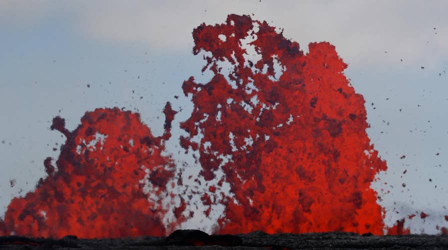
As lava continues to spew from Hawaii's Kilauea Volcano, the eruption is forever changing the landscape on the Big Island.
Kilauea first erupted nearly three weeks ago and since then more than 20 fissures have opened up and dozens of structures have been destroyed.
Satellite photos provided by DigitalGlobe shows bright orange lava coming out of fissures caused by the volcano, running towards the Puna coast, lower right, along Malama Ki Forest Reserve recreation area in Pahoa, Hawaii.

This May 23, 2018, Satellite photo provided by DigitalGlobe shows lava coming out of fissures caused by Kilauea volcano, running towards the Puna coast. (Satellite Image ©2018 DigitalGlobe, a Maxar company via AP)
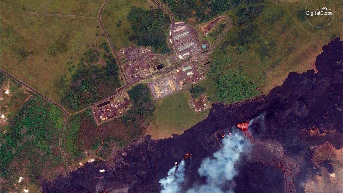
The Puna Geothermal Venture, a geothermal energy plant, can also be seen in satellite photos. Officials said Wednesday the ongoing lava spatter from the eruptions is creating a wall to protect the plant.
U.S. Geological Survey scientist Wendy Stovall told the Associated Press the lava erupting from a vent closest to Puna Geothermal Venture is shooting higher than lava coming out of other vents. It's producing the highest lava wall, which is blocking molten rock from flowing north toward the plant.
This May 23, 2018, Satellite photo provided by DigitalGlobe shows lava coming out of fissures caused by Kilauea volcano, near Puna Geothermal Venture, a geothermal energy plant, in Pahoa, Hawaii. (Satellite Image ©2018 DigitalGlobe, a Maxar company via AP)
Residents have been concerned about hazards if lava flowed over the plant's facilities or if the molten rock heated chemicals at the plant. Officials shut down Puna Geothermal shortly after Kilauea began erupting on May 3, and plugged wells to on Tuesday to prevent any toxic gasses from escaping if the plane became compromised.
HAWAII VOLCANO CREATING BLUE FLAMES FROM METHANE IN CRACKED ROADS
Lava from the eruption on the Big Island can be seen in satellite photos primarily flowing south toward the ocean.
Satellite images provided by DigitalGlobe show a southeast area of the Leilani Estates neighborhood, near Pahoa, Hawaii, May 24, 2017, compared to a year after with volcanic activity.
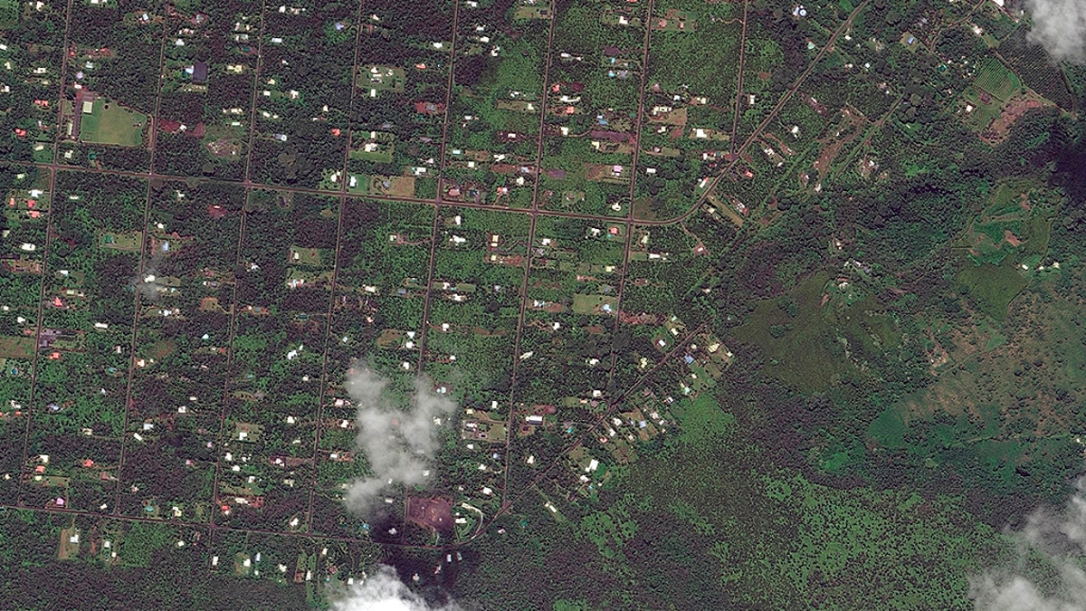
This photo from May 24, 2017 shows the southeast area of the Leilani Estates neighborhood, near Pahoa, Hawaii before volcanic activity caused fissures to open up in the area. (Satellite Image ©2018 DigitalGlobe, a Maxar company via AP)
Hawaii’s volcanic eruptions have been steadily on the rise over the past two weeks, crushing cars and torching homes. Thousands of residents have been evacuated, with some are living in one of three Red Cross shelters, while others have moved in with friends and family.
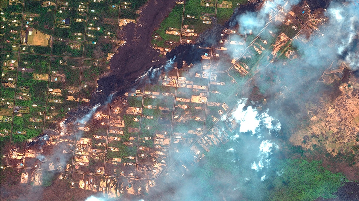
This photo from May 23, 2018 shows the southeast area of the Leilani Estates neighborhood, near Pahoa, Hawaii after volcanic activity caused fissures to open up in the area. (Satellite Image ©2018 DigitalGlobe, a Maxar company via AP)
Kilauea is one of the most active volcanoes in the world, and its recent activity has attracted tourists from across the globe.
KILAUEA VOLCANO GLOW CAPTURED ON TIME-LAPSE CAMERA
There's no telling when Kilauea’s current state of instability will end. Researchers at the Hawaii Volcano Observatory say this year’s eruption is similar to one that occurred in 1955. That explosion lasted three months and produced 24 vents.
When all was said and done, nearly 4,000 acres were covered in lava including neighborhoods, roadways and sugar cane fields.
Fox News' Barnini Chakraborty and the Associated Press contributed to this report.