


National Hurricane Center tracks Hurricane Irma's path
Acting director Dr. Ed Rappaport joins 'The Five'
This is a rush transcript from "The Five," September 8, 2017. This copy may not be in its final form and may be updated.
DANA PERINO, FOX NEWS HOST: A Fox News weather alert. Hello, everyone. I am Dana Perino and this is "The Five."
Florida is bracing for a direct hit. Hurricane Irma now a category 4 storm, wreaked havoc in the Caribbean and is now steadily making its way towards the sunshine state. It is currently forecasted to once again become a Category 5 storm when it makes landfall in the United States.
For the latest on this storm's preparations, let's got to Steve Harrigan, he is in Miami shores, Florida. Steve.
STEVE HARRIGAN, FOX NEWS CORRESPONDENT: Dana, the wind has been picking up every hour, and 5.6 million Floridians have been asked to leave their homes, to evacuate, to leave what they have. They get on the highway and to seek shelter. Of course, such a mass movement has not gone smoothly so far. It's more done double. The previous largest evacuation from Hurricane Rita in Texas and Louisiana in 2005, there's two main roads out of Southern Florida to the North.
Florida Turnpike and I-95. There have been problems on both. At times today, traffic has moved at just five miles per hour. There is a shortage of gasoline. There is a shortage of hotels and when you see the conditions on the road, it makes people scared, scared to stay and scared to leave. And you really see that fear when you talk to people here. To get to safety, you basically have to leave the state entirely. So, what was a five hour drive can be a 10 or a 20 hour drive.
And it makes people hesitant to leave. There have been a number of shelters set up here in Miami-Dade County. At least 40 they say that can hold 100,000 people. But they are places of last resort. And when you hear now from officials, the things on TV, the warnings, first responders can't go out when the winds are over 45 miles an hour. Don't call 911 during the storm, we can't save you during the storm, it all seems counterintuitive.
And it builds into the fear here of what is going on. We see people in the Miami area today really struggle with the decision to seek shelter in their homes to try and ride it out or to get on the highway and hope to find gas and a place to stay. That's not even talking about the potential from the storm surge. It could be 10 feet here along with 10 inches of rain. A 10-foot storm surge means your one-story home could be underwater. So, people still watching that come, watching potential landfall and as that landfall situation changes, more and more people taking to the highway to try to find safety.
Dana, back to you.
PERINO: All right. Steve, thank you so much. Let's now go to Adam Housley, he is in Key Largo, Florida. How's it looking down there, Adam?
ADAM HOUSLEY, FOX NEWS CORRESPONDENT: Well, it's looking pretty empty and that's the good news. A lot of people did get the advice and got up the first evacuation orders were in this part of the state. And I'll tell you, people that here took it for the most part and got out, there are still some here -- I talked to the sheriff's department, you know, we know first responders or some of the few that are saying around. There are some people staying around as well. How are you guys going to handle this the next basically 48 hours?
SGT. SCOTT WARD, MONROE COUNTY SHERIFF'S DEPARTMENT: Basically, we will be active in patrolling in our neighborhoods, up here in Key Largo especially. We will be encouraging any contacts that we make for the residents if they haven't had plans to evacuate, we will have them evacuate immediately for their safety.
HOUSLEY: You know, one of the interesting things you mentioned on the camera is you're getting a lot of phone calls from relatives outside of the state calling your sheriff department for welfare checks. And you just have to go to these homes and try and talk to people out of it. And so far you have not been able to talk anyone out of leaving.
WARD: No. Basically the residents that we did talked to and make contact too, we will reconfirm to evacuate. But they have not set in their minds that they want to stay and ride this one out.
HOUSLEY: I know you and your officers here have all been here before. You see this thing coming. What are your thoughts?
WARD: We pray for everybody involved. Everybody involved. The men and women in law enforcement that are out here, and all the residents that are choosing to stay.
HOUSLEY: All right. Sargent, thanks for your service. Good luck. Guys, you know, we're also here at Tower Pizza, the only place that we found open still anywhere in the Keys. And they're going to close up here. In fact, they've already put the storm shutters over. And they're going to hunker down here in a category 5 location. Basically that means that the buildings here have been built to withstand a category 5. That is where staying as well. And everybody here is just hoping for the best. Hoping the storm continues to move to the West. But right now, that eye is basically pinpointed to right over the Keys, guys.
PERINO: All right. Adam, thank you so much. Be safe down there. For more specifics on the storm's path, let's bring in meteorologist Adam Klotz. Adam, what do you have?
ADAM KLOTZ, FOX NEWS METEOROLOGIST: Hey, there. We continue to watch this eye wall. At this hour get very close to the cubic coast. There it is. Still spinning very tightly. In running up at this point nearly right along the coast, we are expecting it to run basically along the coast here through the overnight hours before eventually turning north and that's when we begin to see Florida get in our eyesight a little bit more.
This is the current forecasted track it goes from that category 4 storm. As I said, running there right along the coast into tomorrow. Finally beginning to do that turn now. Where exactly it turns, that's going to make a really big difference on where exactly this thing lifts up into Florida. But currently what we are looking at is that time it takes to move from Cuba to South Florida. That's the time when it runs over some very warm water.
In doing so, we could see this intensify even more going from a category 4, back up to a category 5 before eventually making landfall in South Florida. Really looking at the time frame there as getting you into Sunday morning, perhaps 8:00 a.m. or 9:00 a.m. That is what we're currently looking out with our models. And then running up the west side of the state, spending almost all of Sunday, moving all the way up the state into Monday before eventually exiting and obviously wreaking havoc the entire way it lifts up the coast.
This is another model taking you along the coast there. And this is what I was talking about, that transition from Cuba to Florida, you run over some very warm water. And that is showing intensity. So, when that pops up there, that's talking about winds suddenly getting very strong right as we talk about making landfall. One of the other problems besides just that initial wind damage is when you talk about that much wind, that's when you start to get a big storm surge.
And some of our most recent models are talking about as much as 10 feet there when you get down on the western tip of Southern Florida. Ten feet above sea level. There are plenty of spots down that way where sea level is right there at the ground. So, we could be talking about an entire first floor underwater, and that's all going to be because of some very powerful winds gusts. Now, these are some models indicating gust getting up into the triple digits. This is going to be a nasty storm if it currently keeps the track it's doing, and that is bringing it right up the west coast.
PERINO: All right. Adam, thank you so much. And we are fortunate tonight to be joined by Rick Reichmuth who is in for Greg Gutfeld. And I've been watching the Fox News weather team cover this storm, and Harvey before, and I think what you all do is absolutely amazing. How does this compare to anything you have covered in the past?
RICK REICHMUTH, FOX NEWS HOST: So, there are a lot of storms that are big and scary. Everyone is a little bit different. Certain storms bring certain dangerous things like the flooding in Houston which wasn't really a landfall of Harvey, it was a byproduct of Harvey. This one is really scary because if the forecast now getting up to a Cat 5 at landfall, that's happened twice in Florida, in all of the history that we are aware of in Florida.
So, it's very rare. Florida's population has exploded also. So, Hurricane Andrew was the last cat 5 that came in. It was 25 years ago. They were 30 million people living in Florida at that point. It also came in perpendicular to the coast. So, it just hit at very little sliver. This one is running straight up the entire Peninsula and there's 21 million in Florida now. So, there are so many people who are going to have hurricane force winds, 150 to 180-mile-an-hour winds which will topple over power lines, flood everything. This is for sure a scary one. Harvey was a scary one. This is a scary one.
PERINO: How long will this whole process take?
REICHMUTH: It will take probably about 36 hours before it's through Florida. So, there will be spots that have 100-mile-an-hour plus winds, probably four in excess of ten hours. So, one thing as the wind comes and hits you but if it keeps hitting you for that long --
MELISSA FRANCIS, FOX NEWS HOST: Wow. One question that I had is, you know, they talk about it when a hurricane, is it a rain event and this one is largely going to be a wind event. What causes that? Is it the speed is moving or is that how big the diameter is? What makes the difference between being a wind event versus a rain event?
REICHMUTH: Yes. So, when we're talking about a wind event, it doesn't mean it's not a rain event. It just means we are focused on the wind of it because that's going to be the biggest threat to it here. Without wind, it comes a storm surge also. But there's going to be 15 to 20 inches of rain as well. So, it's a lot of flooding from that rain. It is coastal flooding from the storm surge. And it is the wind battering all of the buildings and the power lines and the trees that is going to cause power outages. Keep in mind, everybody, for the people evacuated, they went north, and there's only one way in and out of Florida, she is down that Peninsula. So, all of the support in this to get in and to get power back on --
PERINO: It could be while?
REICHMUTH: It could be a while.
PERINO: That is interesting. Jesse and I were looking at each other in kind of sadness and horror for people that are in the car for 20 hours trying to get out. But at least the local and state government has been encouraging an evacuation for several days so the people had some time to plan.
JESSE WATTERS, FOX NEWS HOST: And Governor Rick Scott has done an amazing job. I think everybody agrees with that. I don't understand the mentality of the people that stay. I know there are different types of people that stay. You have your maniacs, sometimes you have your elderly. Sometimes you have people that just can't leave their house because that's all they have --
PERINO: They don't have the means.
WATTERS: Right. Or they don't have the means to leave, they don't have family to go to.
PERINO: Uh-hm.
WATTERS: So, the people that are staying -- I just feel horrible for them because we heard the people say you can't even called 911. No one will help you. There's not going to be an electricity. They're not going to have food. What are they going to do? How are they going to get help?
REICHMUTH: Roadways are going to be cut off as well. So, they can't get to a lot of people. The roads are gone. Trees are over it. In some cases, they will be washed out as well.
WATTERS: And they can't send people when the wind is over 45 miles an hour?
REICHMUTH: Right.
PERINO: I think that's for their own safety.
REICHMUTH: Yes. You know there are the thrill seekers of this.
WATTERS: Right.
REICHMUTH: And there are plenty of these people -- there is also people who think, well, it probably won't be that bad.
PERINO: They've probably heard that before, right?
REICHMUTH: They've warned us a lot of times. And that's a battle we have in messaging all the time right. When do you really make the messaging sincere and scary enough for the event that's coming? But the hard part is people that don't have the means to get out. And they are the ones who really will end up needing the help.
JUAN WILLIAMS, FOX NEWS HOST: Well, you know, I hadn't seen this until today but cops were handcuffing homeless people to get them off the street. And then you heard the people who are in charge of homeless people in Florida saying, if you stay on the streets, you're going to die. In other words, you can't just be out there. You won't survive. That's pretty shocking to me. I mean, there's no way to survive for people that are advocates for the homeless.
PERINO: And Rick, what do we know about the storms damage in the Caribbean as it comes across? Because we've seen some pictures that have been devastating.
REICHMUTH: Yes.
PERINO: A lot of those people have no way to get help, either. And as Adam was saying, he is in a building that was built to withstand a category 5 hurricane.
REICHMUTH: There was a strongest storm that ever went to the Virgin Islands, the strongest storm that went through those Lesser Antilles and they recorded history. And the pictures are terrifying. Ninety five percent of the buildings completely damaged in those islands. And worst to this, there's a storm behind this. It is not going to come to the U.S. I don't want people here to be freaked out about Jose which is behind this but it is a Cat 4 storm and it's going to cut properly within 20 or 30 miles tomorrow of those islands again.
WILLIAMS: Wow!
FRANCIS: So, what are the options at this point? I mean, there's still a chance that it moves in a different direction. I mean, we always see, I feel like the last moment, it goes east, it goes west, that sort of thing. I mean, we don't know, it's not so close right now that it's inevitable or is it?
REICHMUTH: It is inevitable. It is inevitable.
FRANCIS: That it's going to hit Florida.
REICHMUTH: It's going to hit Florida. There is no doubt about that. So, there are not many options, certainly no good options at this point. First of all, we're going into night time. We'll have tropical storm force winds by around 6:00 in the morning in the Keys. We will have the first rain coming in overnight as well. So, the time is kind of up on that. I had a friend text me in Miami earlier this week and he said I can't get north. I can't evacuate north.
I'm thinking of going to Naples. And I said, well, at this point, that might be an okay thing but we are really not sure which way. It's about 100 miles across Florida, one direction or another. And today he said, I was going to Naples, what do I do? I'm like, well, it is going to be bad in Miami and in Naples. That east-west route, you can't really do it. Plus, it's kind of like being stuck between second and third base. You are stuck there, what do I do? Now my time is running up and all the traffic is here and you're stuck. And you don't want to be stuck in your car in one of these storms.
WILLIAMS: So, let's go back to being stuck in the rundown, between, you know, first and second base. Because I see that Georgia, the governor there is also calling for evacuations even as people are coming up into that area trying to escape the storm in Florida.
REICHMUTH: Absolutely. For one thing, Georgia will not be as bad. There will be hurricane force winds in Southern Georgia, maybe all the way up in Central, Georgia, same making. That probably have some 70 to 80 miles an hour wind gust which can topple over some trees and cause some power outages. Comparatively, that will be minor to what is going on in Florida. And I also do think you have to think about if I take the resources, what resources am I taking from somebody else who needs it worse?
So, a friend today in Jacksonville said, my truck has a lot of gas, I would really rather have my car have gas too. And all the gas stations are full. And I'm like, leave your car alone. Those people aren't just Jacksonville people, they're commuting from South Florida to some place in Atlanta and they need to get gas to go on, to get to a house where they can go and stay with a relative or a friend.
FRANCIS: You made an important point that you don't want to be in your car.
REICHMUTH: Yes. You don't want to be in your car. Streets flood. There isn't any way out of that. We saw in Houston --
FRANCIS: Yes.
REICHMUTH: People are trying to do something there. The only place out of the car is into the water, that's flooding into your car.
WATTERS: Tell me about the buildings. Because I heard after Andrew in '93 that they have new codes where you have to build it to a certain level where he could withstand the winds. If you're going to see winds at 100 miles an hour, what buildings will be able to sustain it and what won't be? I know, it seems like residential homes, they are just going to get demolished.
REICHMUTH: A 100 miles an hour, it won't get demolished. It depends, if you have 100 miles an hour for ten or 12 hours, that causes a lot more damage.
WILLIAMS: Right.
REICHMUTH: There will be tons of roof damage. A lot of windows that are blown up. Keep in mind, there is flying debris. So, branches and trees, and light posts, trash cans. All the stuff that's out on the street starts blowing and that wind is going through your windows. So, you know a lot of
--
WILLIAMS: But I don't understand. Melissa and I were talking about this, because we are both big fans of Disney, how come Disney is not closed? SeaWorld I think said they're going to close --
REICHMUTH: I think they are closed for two days if I'm not wrong.
WILLIAMS: No, I think SeaWorld said they're going to close Sunday and Monday or something.
FRANCIS: Yes. We were looking -- they've had made definitive plans yet, but maybe they have set up plans.
PERINO: Folks, we have to move on because we have more on how the federal government is preparing for the storm, doing a lot. Let's bring in Ed Henry. He's at FEMA Headquarters in Washington, D.C. Ed?
ED HENRY, FOX NEWS SENIOR WHITE HOUSE CORRESPONDENT: Yes. Dana, good to see you. This is FEMA's National Response Coordination Center. Now, on what they would call a blue sky day around here, they might have a handful of people. Two, three, four people monitoring cameras, websites, making sure there's not a volcanic eruption and earthquake or hurricane, any sort of natural disaster around this nation or around the world, so that they know what's going on.
Tonight, there's about 153 people behind me here, just a few blocks from the U.S. capital. These are folks, brave federal workers by the way, who have been working around the clock. In this case, since the last Thursday. They are known as the blue team. Its two different groups working 12-hour shifts, you know, around-the-clock, literally to make sure that the federal response is strong. And official here told me, this is literally a historic moment in emergency management history.
Because you have Harvey, now we have Irma, as we've been talking about. But the officials behind me have been working on floods in Missouri, they've been working on forest fires around the country, California, Oregon, elsewhere. And so, there are natural disasters all around this country. And so, there are 153 people behind me as I mentioned, Dana. But about 200 people here in this operation center and then existing surrounding forest, working around the clock to make sure that they get help to people that need it.
PERINO: These are amazing public servants. And Ed, obviously FEMA and the country is stretched in terms of all the resources that you were talking about. This FEMA at this point, need additional resources in order to continue to be able to help, you know, and do what they are doing there in terms of monitoring. And also, they just don't do this on the night of the storm, they are there for the long haul over the course of months in order to help people rebuild.
HENRY: Yes. What they are telling me is that it's most intense for them before those hurricane force winds that Rick was talking about and right after. That basically during the hurricane force winds, it's relatively calm here because unfortunately, there's very little they can do at the most intensity of the storm. So, beforehand, it is very intense here. Prepositioning resources.
And then afterwards, what I'm told happens is you have all kinds of groups behind me that figure out first of all, after those hurricane force winds move through Florida for example and go to other states, they then have to have assessors go in and look at the bridges, look at the runways, have to make sure that they are in place. If the bridges are messed up, you can't just rush trucks and other vehicles in to try to bring food and water and other thinks like that, Dana. Because obviously that is going to cause more loss of lives and it's not going to actually help anybody.
I mentioned this blue team that has been working here around-the-clock since Thursday. They are working right through this coming Thursday and then the gold team is coming in Thursday to work one week straight. Again, two groups working 12-hour shifts around-the-clock. So, there are a lot of federal workers here who are putting their own lives, you know, on pause, if you will. In order to make sure that people in Texas, Louisiana, Florida, Georgia, South Carolina, all of these places are getting the help they need.
A few moments ago, I saw a coast guard official come over here. There's military officials behind me. There's coast guard officials. All kinds of agencies working together, Dana, and everyone else at the table. And the coast guard official was basically saying without giving operations details, that there was one section in the Virgin Islands where people were calling in to a coast guard center somewhere else saying, what can we do to help?
We want to go in and help and frankly, there were people here who are trying to coordinate so many different response areas that they don't know and so they want to do this in a coordinated fashion. And so, anybody in our audience that wants to help, go to the FEMA.Gov website, I'm told. You'll see Harvey and Irma links right there. And in real time, they are trying to update that so that the help of our viewers are giving and people all around the country actually gets to people that needs it.
PERINO: And also, if you are a young person that's watching and you are thinking about what possible career choice you would want, emergency management is an excellent one. You can do it all across the country and especially not just in Washington, D.C. We will going to take it around the table with you, Ed if you can hang with us. We'll start with Melissa.
FRANCIS: Ed, they have to be strict given that they are still dealing with everything that happened in Texas, Harvey, they're still dealing with Harvey. I mean, how much pressure is that putting on the system that now we have another hurricane coming in?
HENRY: Yes. I mean, what I have been stunned by so far is officials I am talking to and obviously there's a lot happening. Some struggling to hear you is that basically, they feel relatively confident that despite all of these various challenges, that they are meeting it as quickly as they can. When you talk about the money that needs to get there, Melissa, there are also, there's a section of budget folks behind me. The split is basically 75 percent that the federal government gives, FEMA, the Federal Emergency Management Agency that we have been talking about.
And then states are responsible for 25 percent of the resources that go to help people. But I am also told that in the immediate hours and days after a storm like Harvey. The federal government does not wait around to get a check cut or reimbursement from a state. That would not make sense. So, a lot of times that the federal government does is pays 100 percent so that when you are dealing with the potential loss of lives, they get as much of the resources as possible so you don't have budget crunchers behind me saying, where's that $5,000? They do have a 75 percent, 25 percent split. But in the initial hours, they don't worry about that.
PERINO: All right. Juan Williams.
WILLIAMS: So, Ed, I was fascinated here. You were talking about the military. The coast guard. You singled out. But I'm hearing that the military is a major component of the preparation for this storm and that they are sending additional resources through Florida. Is this correct?
HENRY: Yes, we have had our colleague Jennifer Griffin, Lucas Tomas at the Pentagon talking about battleships that are prepositioned to try to help as much as they can as I've mentioned. There are also coast guard officials here in this operation center behind me, Juan, trying to make sure that they have the ships, they have the resources to get the help that they need in particular, the anecdote I mentioned a moment ago, there is a coast guard official talking about people in the Virgin Islands who have obviously already been hit by Irma.
Now saying what can we do to help people who are in Puerto Rico? And so, again, you have these multilayers of these multiple storms, going to different places, different islands, different parts of the United States and different territories. And so, what the military is trying to do is coordinate that as well -- Juan.
PERINO: Jesse Watters?
WATTERS: Hey, it seems like FEMA as an agency has really improved over the last several years. You had a bad reputation as you know many, many years ago. But it seems to get better and better and better. Do you attribute that to just to experience and learning from mistakes. Do you attribute it to new technology?
HENRY: Yes.
WATTERS: And then lastly, what's the morale like over there at FEMA right now?
HENRY: Yes. Well, Jesse, two good questions. One is, in terms of how if they got better? One way clearly and federal officials I've spoken to is painfully in some cases obviously, they learned a lot of lessons from what went wrong with Katrina, for example. And so, what federal officials are telling me, one thing they learned more than anything is, you have to preposition as much as you can.
There is also so much you can do as the storm is heading and in the immediate aftermath, and its search and rescue recovery efforts. And so, that's why when you are mentioning Governor Scott, I heard you a moment ago saying, what a great job he's been doing down in Florida. The key is getting people out of these dangerous areas beforehand. There's only so much that these federal employees can do if people stay in place as they are supposed to evacuate from. And your second question was?
WATTERS: About the morale? What's the mood like there?
HENRY: The morale. So, I want to get give you one quick example, because you don't hear this about federal employees all the time. People beat up on them and whatnot, as I was coming into FEMA headquarters, I saw a lot of these employees who I've mentioned have been working around-the-clock, bringing their kids back to work with them. I saw little children getting on elevators with mom and dad. You know, with Mom has got a Starbucks and dad has something from all Melvin Pom (ph) down the street.
So, what they're doing is, because we asked the question too, do they bring in food? Did they bring in drink? And then of course there are critics saying, well, the federal government spending all this money on food. So, basically, they don't. So, these people are working around the clock, these federal employees. They have families just like everyone else. And they are going and they are juggling as much as they can.
So, the morale I've seen so far is a lot of people seem to be in good spirits and dealing with this -- most of them are huddled behind their computers trying to coordinate, communicate, and do all that. But I've seen the personal side of it as well. And they seem to be dealing with it okay.
PERINO: We have time for one last question from Rick.
REICHMUTH: Yes. So, Ed, you know, I know a lot of times when there's a big storm and then a new storm happens behind it, the new storm sucks up all the oxygen just at least in media and in energy. All of this energy that is now going to Florida because of Irma. If Irma wasn't happening, we would still be talking about Houston. There are a lot of people who are in Houston still in desperate need, FEMA goes in for the long run as Dana was saying. If you are somebody in Houston, there is a message to people there are saying, the resources aren't gone, there's still assistance here.
HENRY: Yes, and so, that's a good question. Specifically, I don't know how much of what you can see behind me. But right behind me, there's a red shirt on that chair. So, there is a group of redshirts. And they are doing research support, in addition to the federal officials that I mentioned. In addition to the military. U.S. corp of an army engineers handling handbags. There is also the Red Cross and the Salvation Army just to my left here.
So, you have these private groups working in partnership with the federal government to say just what you said, we are not forgetting about the people who are suffering from Harvey. And only dealing with Irma. They are also dealing with Harvey. And then a little bit behind where those redshirts are, there are blue shirts. Those folks are the folks who wore the blue polo shirts, you see sometimes at news conferences at FOX and other networks here and I'm told what they focus are, in our situational reports where they coordinate exactly how to get the resources to the people that need it.
So, quick example, you want to bring in a whole bunch of bottled water and you're going to fly it in to some place in Florida. Well, there's only so much runway space. So, they've got to coordinate with people on the ground. You can't just bring in all kinds of pails of waters if the Miami airport doesn't have the space for it. Then, once you get that situational report, I am told by officials here, they need to coordinate with someone else to say, how are we going to coordinate the forklifts, to go to that spot on the runway, get the water and then bring it out to the shelters where people need it.
This is a monumental task but so far, you've seen very high marks for this agency. But as everyone has been noting, they're going to be challenged yet again -- guys.
PERINO: All right. Ed Henry. Thanks so much for that important picture for us.
HENRY: Thank you.
PERINO: We appreciate it.
All right. Let's bring in a person who knows more about Irma than perhaps anyone else except for maybe Rick.
Dr. Ed Rappaport. He is acting director of the National Hurricane Center. Sir, what can you tell us tonight?
DR. EDWARD RAPPAPORT, NATIONAL HURRICANE CENTER: I can tell you that we still have a very dangerous hurricane and what we are most concerned about is the storm surge that we've been talking about. The rise of the water being driven ashore by the wind. And in this case, we are looking at a storm surge that could be five to 10 feet deep on the Florida Keys first and then potentially on the South East Coach of Florida followed by even higher storm surge, six to 12 feet on the South West Coast of Florida.
These are examples from the past where you can see what storm surge looks like. The kind of damage that can occur. And here is the area that we are most concerned about, colorized here. And you can see a long area along the East Coast of Florida and then along the West Coast and the Florida Keys. All are susceptible to storm surge. This is where we have a storm surge warning. First time the National Hurricane Center -- the national services issue that this year. And what that indicates is that there is a likelihood or an expectation of life-threatening inundation. That's what that five to 10 feet means.
PERINO: How does this compare to storms that you've covered in the past? Obviously, you are an experienced professional. You study these all the time. We were talking about it as a historic storm. Is that accurate?
RAPPAPORT: Yes. The last storm that was even close to this and had somewhat of similar track, potentially was, way back in 1960, hurricane Donna. It came sure as category 4 and caused extensive damage across Florida. Much less popular than -- much less infrastructure back then. We are very concerned -- we are most concerned at least at first with the Florida Keys because the water level rise will come close to or potentially top a number of those keys, and then you have the weight damage on top.
PERINO: Wow!
REICHMUTH: Ed, as a meteorologist here, I am interested in the last forecast from the National Hurricane Center, strengthened its back to a category five right before landfall. Somewhere along the keys. What is the thinking from the National Hurricane Center on bringing that back to a five?
RAPPAPORT: We have to remember, the difference between a category 4 where we are now and a category 5 where we are forecasting is five miles an hour. All that is consequential when we are talking about winds that are 150 miles an hour. So, 155, 160, 145. There you get basically the same kind of damage, same kind of storm surge. You do not want us to be fixating either on the exact intensity or exact track. This is a large storm that will cause a potentially devastating damage over a large area.
PERINO: Jesse?
WATTERS: Doctor, I am not a meteorologist so excuse me if this is a stupid question, what variables are in play right now that can either make this thing more dangerous, speed up the winds, make it more treacherous or slow this thing down and perhaps, you know, lessen the blow?
RAPPAPORT: The most significant factor that is ahead of us now and really the only one is, if the center of the hurricane should cross the coast of Cuba. It's very close now and we have a forecast that is right along the north coast before turning to the north. Ultimately what that will do, is it will bring the maximum wind speeds down but it won't change really the overall structure. So, what we were expecting is still a large area of hurricane force winds, a large storm surge but maybe we won't have the winds at 155 or 160 miles per hour.
PERINO: All right. Dr. Rappaport at the National Hurricane Center. Thank you so much. We appreciate your expertise.
And coming up, more on the massive response to Hurricane Irma.
(COMMERCIAL BREAK)
WATTERS: Welcome back to "The Five," we are keeping track of hurricane Irma, category 4 hurricane, probably going up to a category 5 at that may threaten the entire state of Florida. Evacuations underway and very, very scary. Let's bring in now Meteorologist Adam Klotz from Fox weather center.
KLOTZ: Hey Jesse, I'm keeping my eye on south Florida at this point. This is a radar image. That storm is still a ways to the south but we are beginning to see these thunderstorms were closer and closer to the Florida coast and actually a couple of thunderstorms firing up, the brunt of it still a ways away. You are beginning to see that inch closer and closer. The eyewall of this storm is down to the south running right up along the coast of Cuba and as we have learned over the last half-hour, this contract out over the coast a little bit more and get a little bit more land.
Maybe that slows it down a little bit but we are expecting to see this run just along the coast or just north of the coast before eventually making a turn. More and more recently, our models are in agreement that it will run right up the west coast of Florida. This is our GFS, our Euro model open up in a motion for you.
Think of the landfall early on Sunday morning. Both seeing that turn and then basically running right up the coast or to the center of Florida, taking you throughout the day on Sunday and Monday before eventually running your way up into Georgia and even there, getting up into the middle of Georgia, bringing some very powerful wins in that entire direction. No surprise, hurricane watches and warnings in south Florida will become a warning in central Florida before long. I will leave you with this. Remember there is Irma, we still have Jose behind it. Running through some of those same islands. Some people who have already been absolutely devastated and have to pay attention to a storm just around the corner.
WATTERS: All right thank you very much. We will be right back with live reports from Florida.
(BEGIN VIDEO CLIP)
UNIDENTIFIED FEMALE: It is very scary because the hurricane is so big.
UNIDENTIFIED FEMALE: Everybody has their shutter down, get fans, get batteries for their flashlights, get canned goods and that it, and weather it out.
(END VIDEO CLIP)
(COMMERCIAL BREAK)
(BEGIN VIDEO CLIP)
UNIDENTIFIED MALE: Yourself or your family, don't be in harm's way. Please go to a shelter. This storm is wider than our entire state. Possessions can be replaced. Your life and your family cannot.
(END VIDEO CLIP)
FRANCIS: Hurricane Irma has killed nearly two dozen in the Caribbean. Floridians need to heed the warning of their governor and other local officials. This is an extremely dangerous storm. Let's check in with Fox News Rick Leventhal, live in the ground in Daytona Beach, Rick?
RICK LEVENTHAL, FOX NEWS NEW YORK CORRESPONDENT: Melissa, Daytona Beach is not deserted but it's getting close. It's very quiet and most of these oceanfront hotels are either empty or will be kicking out their guest's tomorrow morning by 11:00 a.m. A mandatory evacuation order is in effect for low-lying areas, Beach side where we are and everyone in manufactured homes, he doesn't know how many people actually heeded that warning but they are opening but they are opening 21 shelters tomorrow and we did see people getting ready to get out, at least boarding up their homes. Primarily here close to the Beach. We also saw a lot of people closing up their businesses in Daytona Beach. Among them, Rosie and Frank Mirino who opened an Italian bakery just a year and half ago and are now dealing with their second hurricane since then.
(BEGIN VIDEO CLIP)
LEVENTHAL: How are you prepared? What are your plans?
ROSIE MIRINO, ITALIAN BAKERY: Boarding up, making sure everything is secure. Sandbagging. Hopefully we won't lose power.
LEVENTHAL: Is this tough for you?
R. MIRINO: A little stressful.
FRANK MIRINO, ITALIAN BAKERY: We did it last year. We did the dress rehearsal. Everything will be good.
R. MIRINO: Not our first rodeo.
(END VIDEO CLIP)
LEVENTHAL: In south Daytona Beach, we saw a major sandbagging operation earlier today, locals filling bag with 400 cubic yards of sand in this one location over the past three days, some sandbagging operations we were told will be up and running tomorrow in Volusia County. But that will probably be the last chance for anyone to bag their homes, because the storm is expected to get pretty bad starting around midnight tomorrow night, we could have tropical storm force winds into the early morning hours and they are telling us hurricane force winds here in Daytona Beach by sometime late Sunday night, depending on which way the storm goes.
FRANCIS: All right Rick, thank you. Miami-Dade County is struggling carry out the largest evacuation effort in its history. More than 650,000 people. Bryan Llenas is there in Downtown Miami, joining is now, Bryan, he looks pretty empty behind it.
BRYAN LLENAS, FOX NEWS CORRESPONDENT: It is. This is actually Bayside, the intercontinental hotel, we are in downtown Miami. Normally on a Friday night, this is bustling with people. This parking lot over here, full of cars. The intercontinental hotel tonight, keep safe and keep calm, Miami. That is the message here. Look at, we are expecting a devastating storm surge. Over here to my right is bayside. I used to go there as a kid. He would go see mansions, famous people, all the islands, toward south Beach. We fully expect the water here, 5-6-foot storm surge to inundate where we are standing right now. That is the Holiday inn with wood panels on it. That is evacuated. We are in one of the mandatory evacuation zones, some 600,000 plus people in Miami-Dade told to evacuate. But if you will notice over here on this side the condominiums over here, the tall towers, there are still people here despite the evacuation order, the lights are still on and I have to stress, as a category 5 hurricane, you are talking about 156 miles an hour plus. As you come up those, the winds are felt more and more. When you have a storm surge on the first floor, this is what the officials are worried about. If something happens to you, they can't get to you. That is the problem. They've been warning people that have decided to stay in their condos, go to a stairwell in that sense.
FRANCIS: Wow. Bryan Llenas, thank you. So directly ahead, we are going to ask Rick what we need to know about hurricane Irma now, stay with us.
(COMMERCIAL BREAK)
(BEGIN VIDEO CLIP)
UNIDENTIFIED MALE: This storm has taken lives already and it will take more unfortunately if we are not prepared. Please, take it seriously. Start thinking a little bit more seriously about getting yourself into a safe place and out of danger.
(END VIDEO CLIP)
RICK REICHMUTH, FOX NEWS METEOROLOGIST: Such great advice. Welcome back. We are continuing to track Irma. Obviously, possibly the worst storm we have seen anywhere in the U.S. and may be about 25 years. I think this is a good time. I always think I'm giving the right information. Sometimes I don't know what people really want to know. Let's open this up and you guys ask the question.
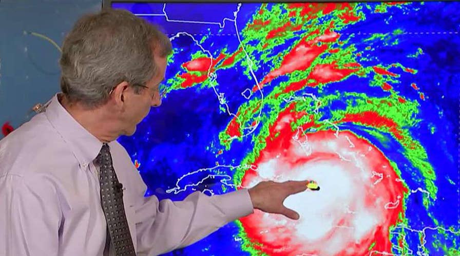
WATTERS: When we look at the graphics swirling, what does the red and yellow mean?
REICHMUTH: Great question and we never say it. By the way, we make those colors. That isn't necessarily like a standardized thing. Every news --
WATTERS: The red looks dangerous.
REICHMUTH: The darker the red, the higher the cloud -- the satellite that is looking down on that is picking up a higher cloud top. Generally, that means a higher storm. It goes out towards the end for the yellow that the lighter part of the storm.
FRANCIS: My question is about the surge. When the water comes pouring in and they talk about that is what everyone is most concerned about, does the water come in and stay or is it like a wave where it washes in and pulls back out?
REICHMUTH: If the storm comes in perpendicularly to a coast, if it comes straight out at, as it does, on one side you have all that water pooling in. Once the storm goes out, the rotation of that storm pushes it away. It could be up pretty quick event. It was not quick with Harvey, where it made landfall. The wind just stayed on shore.
FRANCIS: Why?
REICHMUTH: Because it was not moving. It wasn't moving. It kept the wind moving in the same direction.
FRANCIS: What makes the storm move or not move?
REICHMUTH: That is a separate question. In this case, the storm is not going to stay in one spot. It is moving perpendicularly or parallel to along the coast. It is moving along the same orientation as the state of Florida is. It's going to continue to see the same direction of wind on each side of the storm for quite a while. The storm surge is going to be different. One other thing that makes it different is if you have an elevation gain after landfall. The storm surge, say it is 15-20 feet, it hits it but elevation comes up, that water cannot go any further. Much of Florida is flat. A lot of the coastal areas, the elevation is to have been 4 feet above sea level. Way inland, you can have a storm surge that goes miles inland in a way that it would not in another place. That is what so concerning in Florida.
PERINO: Within the last hour, there was a tweet from Governor Rick Scott. I think that we had it here. This is amazing. I don't think we have seen this. A call from -- for nurses. Florida needs 1,000 volunteer nurses to help in our special needs, shelters so if you think you can help, there's an email for you to check out. Rick, you're also Rick. Not governor Rick Scott. I think people don't realize how long the hurricane season is. I learned this when I worked for the government. Its six months, from June 1st to December 1st.
REICHMUTH: You have to have warm enough water for these storms to form.
PERINO: Is there a science -- there have been big storms since Hurricane Sandy. When you are tracking this, what tells you if there's going to be a bigger storm season?
REICHMUTH: there are a lot of variables to it. There's an oscillation --
PERINO: Jesse can spell it.
REICHMUTH: Like every 20 years ago, there is an active period in than a less active period, historically. There are also things like El Nino or La Nina, the winds in the upper level more conducive or less conducive to there being more storms and then the water temperatures higher or lower than average? This year, just in place for an active season. Last peak? Six month long but September 10th -- we are two days away.
PERINO: I know you have been up for several days.
WILLIAMS: It begins as August as I recollect and goes through September and early October?
REICHMUTH: It ramps up in September 10.
PERINO: Hurricane Sandy was October 30th.
REICHMUTH: It was very late. The season is long.
FRANCIS: I am taking back to my second question about whether it's sitting or moving quickly -- what causes it either stall or to move, this one is a fast moving storm, why?
REICHMUTH: I'm going to get super nerdy on you on this one.
FRANCIS: I love that.
REICHMUTH: All right so this storm All right kind of formed down in the lower latitudes around the equator, roughly. The earth is rotating. The storms move along the rotation of the earth.
FRANCIS: Ok.
PERINO: We follow.
REICHMUTH: Because the rotation of the earth, the Coriolis effect, and wants to curve north. Like something spinning -- that energy wants to put it up north. In the Atlantic, there is the thing the Bermuda eyes, very high pressure in the Atlantic and these storms want to move north but there's higher pressure north. It's not letting it move to the north. Something has to create a weakness in that high-pressure to give it the space to move it where it wants to move. These are cold fronts. Low pressure. You need a stronger cold front to create a weakness in that high-pressure and then the storm will cut into that direction.
FRANCIS: Where does the speed come in?
REICHMUTH: The speed of it is how strong that low pressure is.
WATTERS: Melissa, weren't you listening?
(LAUGHTER)
FRANCIS: We did not talk about the acceleration.
WATTERS: The oscillation. If you are paying attention.
REICHMUTH: How strong that area of pressure, how big that weakness is, if that weakness is really --
FRANCIS: I was calculating the second derivative. See?
WILLIAMS: Rick, imagine that we are back in "the wizard of oz." Dorothy has a question for you. Dorothy says auntie and tells me to go in the basement and hide.
PERINO: That was up tornado.
(LAUGHTER)
WILLIAMS: Yeah, but what happens when the storm surge comes and you are, as we've heard from certain people in the keys, going into what they think it's a bunker? Does the bunker save you if there is a storm surge?
REICHMUTH: If you are below, the waters going in. The water comes in and goes up and you have to go to a higher level of your house.
WILLIAMS: Same thing in the condos they are saying if it floods, they can't get you.
REICHMUTH: Get to the innermost point of your house. At the many walls between you and the outside as you can and less windows between you as well. If you're really scared, put a mattress or something over you.
WILLIAMS: Not the bathtub.
REICHMUTH: Put something over you to protect yourself. Those are all of my tips.
PERINO: Well done Rick.
REICHMUTH: Thank you very much. Some final thoughts coming up in just a moment.
(COMMERCIAL BREAK)
PERINO: Back now with our continuing coverage of hurricane Irma. Currently making its way to the United States after tearing apart the Caribbean. Stay with the Fox News channel throughout the night and all weekend for the very latest developments. Rick Reichmuth is going to be back for Fox & friends. You continue to watch tonight and first thing in the morning as we see that storm, sure. To all those in the storm's path, please heed the warnings from local and federal officials. I'm sure the damage we saw in Houston will be evident in Florida as well. We will see you back here on Monday, September 11th. Much more to come on "Hannity," up next.
END
Content and Programming Copyright 2017 Fox News Network, LLC. ALL RIGHTS RESERVED. Copyright 2017 CQ-Roll Call, Inc. All materials herein are protected by United States copyright law and may not be reproduced, distributed, transmitted, displayed, published or broadcast without the prior written permission of CQ-Roll Call. You may not alter or remove any trademark, copyright or other notice from copies of the content.