


Hurricane Laura gains strength as storm enters Gulf Coast
Fox News senior meteorologist Janice Dean has the latest.
Prior to being upgraded to a hurricane, Laura was spotted from the International Space Station, showing how wide the storm is.
The external cameras on the orbiting space research laboratory captured the storm as it was making landfall in Cuba on Aug. 23. The cameras captured the images from approximately 250 miles away, ABC 13 reported.
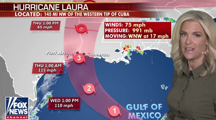
Since then, Laura, which is now a Category 3 storm, has been moving across the southeastern Gulf of Mexico, prompting hurricane and storm surge warnings.

Tropical Storm Laura as it hovered over Cuba. It is now a Hurricane. (Credit: International Space Station)
TROPICAL STORMS MARCO AND LAURA CAPTURED ON NASA SATELLITE IMAGES
The storm is already responsible for the deaths of at least 11 people in the Dominican Republic and Haiti, where it knocked out power and caused flooding in the two nations that share the island of Hispaniola. The deaths reportedly included a 10-year-old girl whose home was hit by a tree and a mother and young son who were crushed by a collapsing wall.
On Tuesday, a National Hurricane Center advisory said strong winds, heavy rainfall and flooding are likely to occur inland along the storm's path.
"In addition to storm surge & wind threats, Hurricane #Laura is expected to produce a swath of heavy rainfall as it moves inland Wednesday night into Saturday," the National Hurricane Center tweeted. "This rainfall will cause widespread flash & urban flooding and isolated moderate river flooding."
There is the potential for a life-threatening storm surge over a large portion of the Gulf Coast from San Luis Pass, Texas, to the Mouth of the Mississippi River and a storm surge warning is in effect for this area, according to the hurricane center.
NASA's Johnson Space Center in Houston continues to monitor the hurricane and is making general preparations. This includes a small team of flight controllers for monitoring and sending commands to the most important space station systems, which were sent to a backup control center hub in central Texas in advance of the storm, NASA said in a separate statement.
The U.S. space agency has been providing infrared images of the storm via its Terra satellite, as well as the Suomi NPP satellite that it operates in conjunction with the National Oceanic and Atmospheric Administration, the agency said in a blog post on its website.
On Monday, NASA satellite images showed Tropical Storm Marco and Laura swirling in the Gulf of Mexico and near Hispaniola, respectively.
Fox News' James Rogers contributed to this story.