


Fox News Flash top headlines for July 26
Fox News Flash top headlines are here. Check out what's clicking on Foxnews.com.
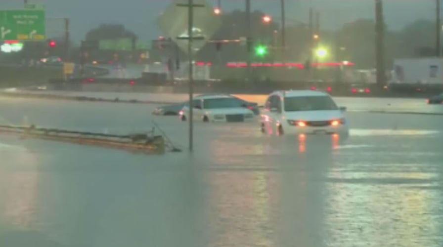
Historic rainfall around St. Louis on Tuesday led to flash flooding that submerged cars in a river of water on Interstate 70 and trapped people inside their homes.
Flash flooding led to numerous road closures across the St. Louis metropolitan area after a record-setting 6 to 10 inches of rainfall caused widespread flash flooding, the National Weather Service’s (NWS) office in St. Louis said early Tuesday.
St. Louis recorded 8.06 inches of rainfall in five hours since midnight, shattering the city’s old daily rainfall record of 6.85 inches logged in August 1915, the NWS said.
Fire companies have responded to about 18 homes with substantial flooding and trapped occupants, the St. Louis Fire Department said. As of early Tuesday, officials said firefighters rescued six people and six dogs trapped in the flooding via zodiac boat, while another 15 people were choosing to shelter in place.
Video shared on social media showed that the record rainfall turned I-70 into a river, with multiple vehicles stranded in high water.
Firefighters were seen in some videos checking on motorists on the flooded roadways.
Another user shared a photo of floodwaters nearly rising over the roofs of cars on her street in St. Louis.
While the NWS said the rainfall was expected to taper off around 10 a.m., a flash flood warning would remain in effect until 12:15 p.m. local time in the areas around O’Fallon, St. Charles and St. Peters.
CLICK HERE TO GET THE FOX NEWS APP
The agency also warned of isolated thunderstorms Tuesday afternoon and evening across southeast and east-central Missouri that could bring damaging 60 mph winds and hail the size of quarters.
In addition to the record rainfall and potential thunderstorms, the agency said a heat advisory was also in effect for parts of southeast Missouri on Tuesday afternoon and evening, with peak heat index values of 100 to 110 degrees expected.


True Crime
The hottest stories ripped from the headlines, from crime to courts, legal and scandal.
By entering your email and clicking the Subscribe button, you agree to the Fox News Privacy Policy and Terms of Use, and agree to receive content and promotional communications from Fox News. You understand that you can opt-out at any time.
