


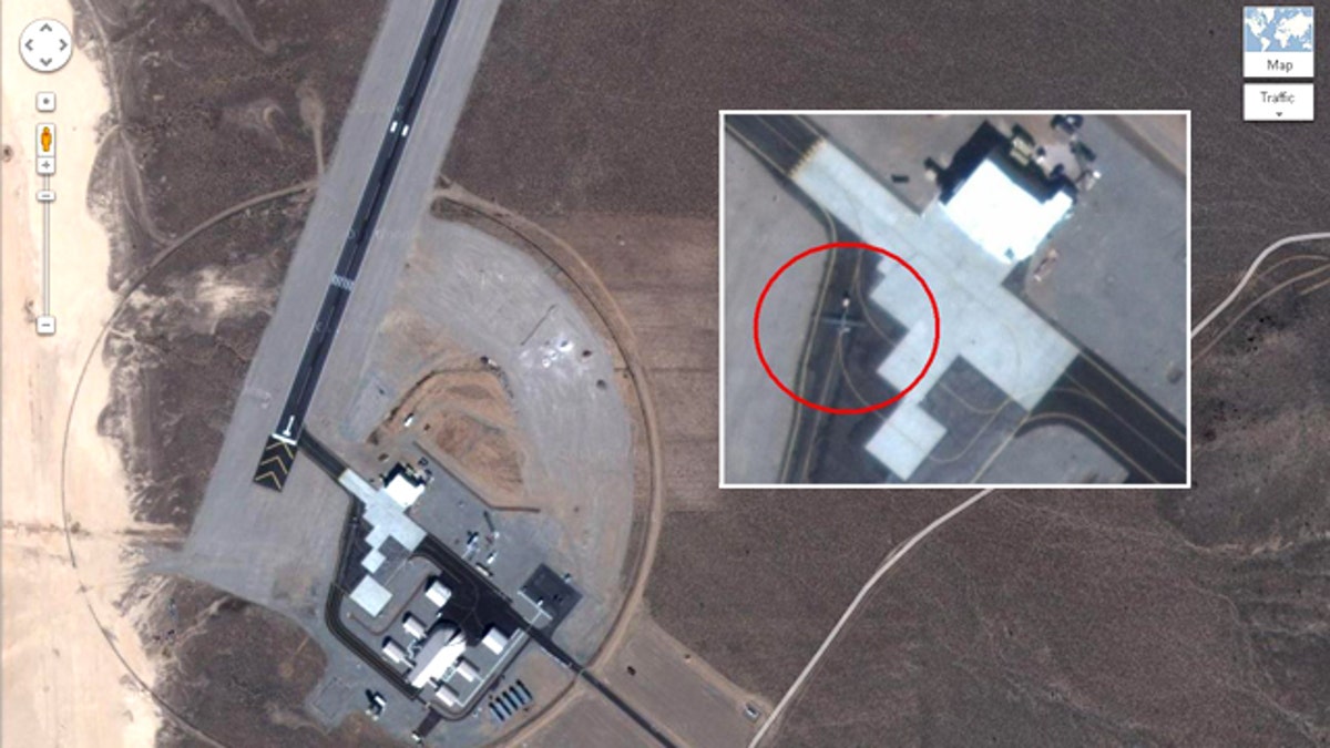
New satellite images posted on Google Maps reveal a secret air base in Yucca Lake, Nev., where drones (circled, either a Predator or a Reaper) and even the top secret RQ170 are reportedly tested. (Google Maps)
Editors’ Note: This story was updated Tuesday, Dec. 13, to include comments from imagery analyst Tim Brown.
Google may be compromising national security – all in the name of better mapping technology.
At Google Maps, anyone can search for the names of military bases and zoom in to see airstrips and possibly even top-secret military drones like the RQ-170 Sentinel lost in Iran last week. Aviation website Flight Global has done just that, and claims to have found the secret airstrip at Yucca Lake, Nev., used for testing the RQ-170.
The Google Maps site shows satellite images of either a Predator or Reaper drone on the airstrip, although Flight Global says the RQ-170 was tested there as well -- information that’s surely of interest to the Iranian military, said Cedric Leighton, a retired Air Force colonel.
“Iranians would be most interested in operational bases because that tells them how we fly our surveillance missions,” Leighton told FoxNews.com.
Sure enough, other Nevada military bases at the Tonopah Test Range like the Creech Air Force Base are also viewable at Google Maps. With this information, anyone -- even foreign military -- can look up satellite images to inspect secret U.S. spy planes.
“Google is making public what was once the sole province of the military and intelligence community, making this a brave new world for the intel agencies as well,” he said.
Google did not return FoxNews.com requests for comments, but other experts disagree that Google Maps could present a military security issue.
“It’s impossible for Google Earth to be a threat to U.S. security,” Tim Brown, an imagery analyst with GlobalSecurity.org, told FoxNews.com.
The U.S. military has bought nine copies of the Google Maps database, he said, both to allow the military access to the high-res imagery and to prevent any such information from escaping.
Beyond that, it’s illogical to test the RQ-170 at the Yucca Lake test strip -- especially when the famous air base at Groom Lake (where Area 51 is located) is just around the corner.
The largely unknown RQ-170 drone from Lockheed Martin -- the U.S. Air Force's official Fact Sheet is a single piece of paper with precisely 100 words of information -- made headlines recently when it was lost in western Iran. Experts say the drone is the most advanced model yet with high-definition cameras, sensors that can scan for nuclear armaments, and an advanced stealth shell that hides the plane from detection.
On Thursday, a senior U.S. official exclusively confirmed to Fox News that the crashed drone shown on Iranian state television is indeed a fully intact RQ-170 Sentinel -- amplifying concern about the satellite imagery.
Leighton told FoxNews.com that Google has the right to show these images to the public, but they should decide not to because they comprise military operations.
Most satellite images are delayed and do not show current military research, military sources told FoxNews.com -- though none were willing to go into more detail.
Is it legal?
The debate over satellite imagery of top secret bases has raged for some time. Previous satellite images showed a secret military base near Denver and in Pakistan's Balochistan province, where images of the Shamsi Airfield showed Predator drones sitting on a parking ramp, ready for deployment.
Yet, with the bleeding-edge RQ-170 lost in Iran, there are new questions about how these images could aid countries that are hostile to the U.S. -- and now possess military technology.
Leighton said the U.S. military has previously blocked Google employees from capturing images at military bases for the Google Earth program, which requires close-up photography.
Dr. John Michener, chief scientist at security firm Casaba, doesn't see a problem with Google Maps showing spy plane imagery. He says national laws do not apply above the atmosphere, and the mass public now has access to the same satellite images used by governments for decades.
His advice to the U.S. government?
"Get used to it," Michener told FoxNews.com. “You know when the satellites are overhead. You can take countermeasures to hide portable stuff.”
At the same time, Michener says there would be a problem in terms of security if the government decided to filter through "deep-packet inspections," ultimately inserting code onto the Web that blocked access to secret images.
That would drive Google to add encryption to the images -- something Michener says may be inevitable.

Get a daily look at what’s developing in science and technology throughout the world.