


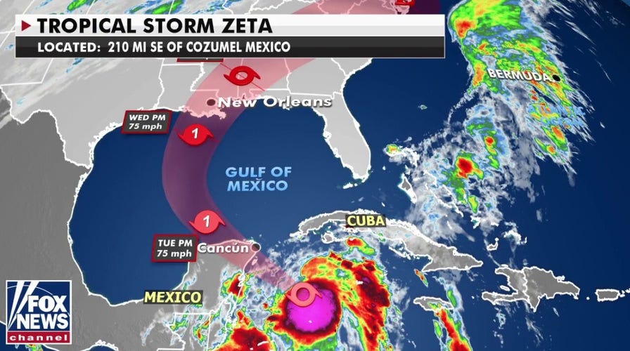
A strengthening Tropical Storm Zeta is taking aim at Mexico's Yucatan Peninsula on Monday before the storm is forecast to target the U.S. Gulf Coast by this middle of the week.
The National Hurricane Center (NHC) said that Zeta is located about 120 miles southeast of Cozumel, Mexico, with maximum sustained winds of 70 mph, moving northwest at 10 mph.
Forecasters from the NHC said a NOAA "Hurricane Hunter" aircraft found early Monday morning that Zeta is "rapidly strengthening," and that hurricane conditions and storm surge are expected across portions of the Yucatan Peninsula by later in the day.
TROPICAL STORM ZETA FORMS, FORECAST TO BECOME HURRICANE AND TRACK TOWARD GULF COAST
Zeta is forecast to become a minimal hurricane before reaching the Yucatán near Cozumel and Playa Del Carmen on Monday night.
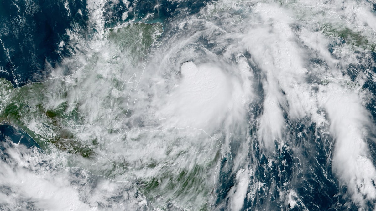
Tropical Storm Zeta is strengthening Monday as the storm approaches Mexico's Yucatan Peninsula. (NOAA/GOES-East)
A hurricane warning was expanded for the Yucatan Peninsula from Tulum to Dzilam, including Cancun and Cozumel.
Officials in Quintana Roo state, the location of Cancun and other resorts, said they were watching the storm. They reported nearly 60,000 tourists in the state as of midweek. The state government said 71 shelters were being readied for tourists or residents who might need them.
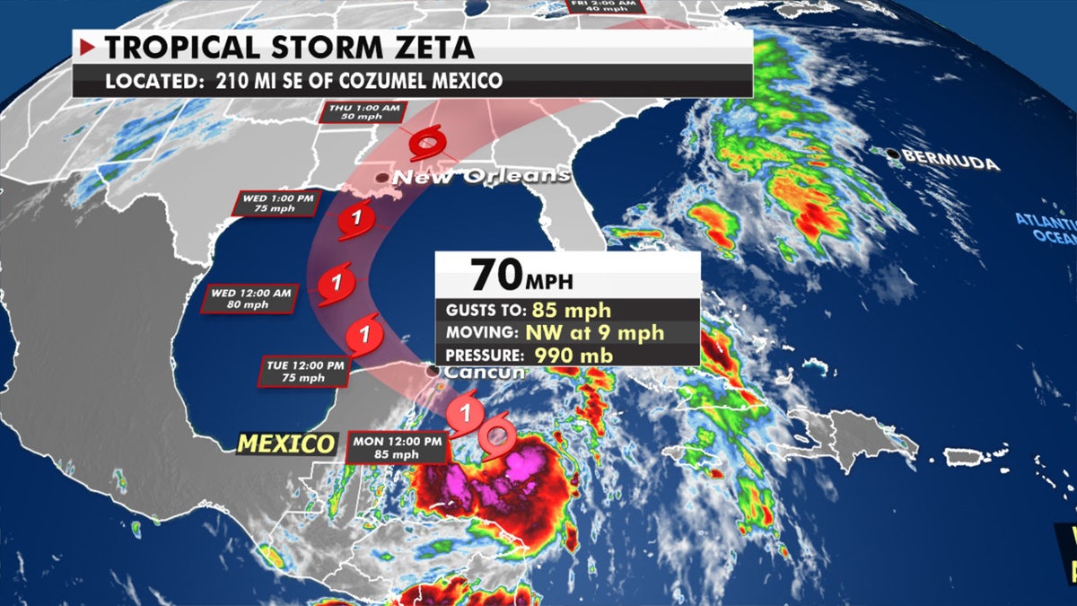
The forecast track of Tropical Storm Zeta. (Fox News)
The region is still recovering from Hurricane Delta and Tropical Storm Gamma earlier this month.
Zeta is forecast to enter the Gulf of Mexico by Tuesday, and then track towards the U.S. Gulf Coast by Wednesday.
The storm will then threaten the storm-ravaged Louisiana coast.

"We're expecting a landfall we think sometime Wednesday afternoon into Wednesday evening," Fox News senior meteorologist Janice Dean said on "Fox & Friends." "Possible as a minimal hurricane with heavy rainfall, the storm surge, the potential hurricane-force winds along this vulnerable coastline that has been hit so many times."
HURRICANE EPSILON'S EYE REVEALS 'STADIUM EFFECT' AS POWERFUL STORM TO SIDESWIPE BERMUDA
It's not yet known how strong Zeta will be when it approaches the coast. Previous storms have rapidly strengthened this year when over the warm waters of the Gulf of Mexico. The most recent forecasts show Zeta could make landfall anywhere from Louisiana to the Florida Panhandle as a strong tropical storm or minimal hurricane.
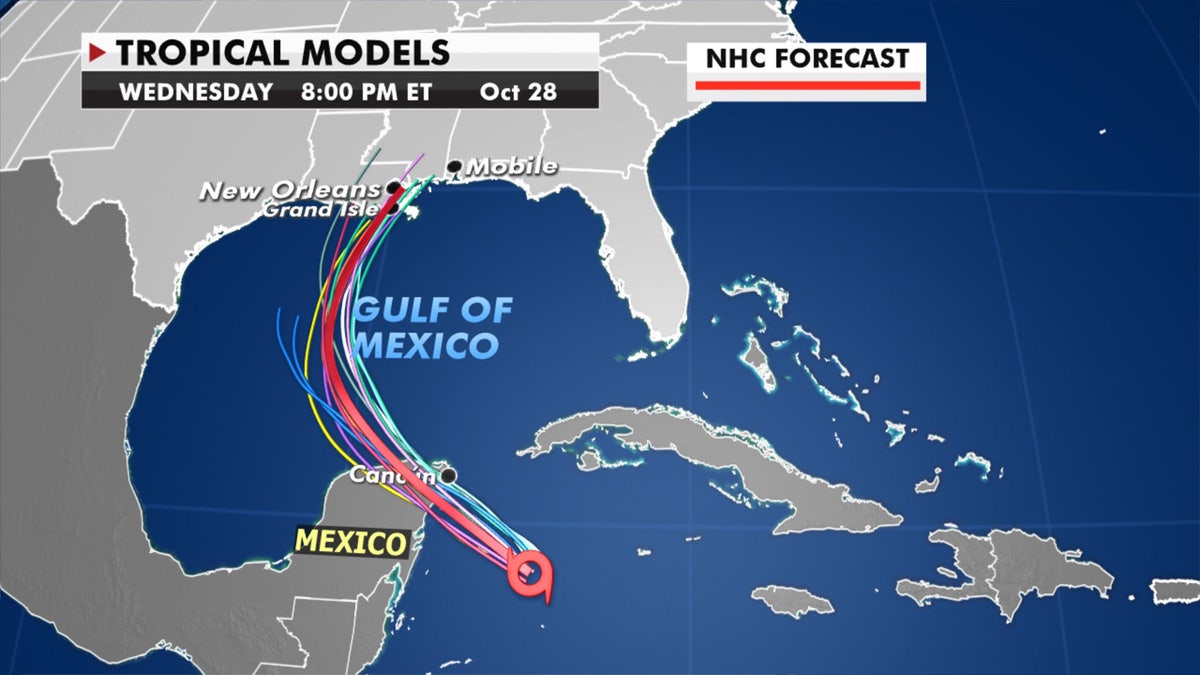
Forecast models showing the track of Tropical Storm Zeta. (Fox News)
This southeastern Louisiana to Florida Panhandle region is no stranger to hurricanes and tropical storms, especially this year. Overall rainfall, surge, wind impacts of a strong tropical storm or even a minimal hurricane won’t be even close to the severity of a major storm.
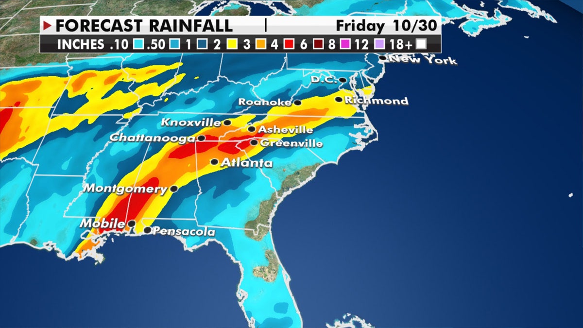
Potential rain amounts through Friday after Zeta makes landfall along the Gulf Coast. (Fox News)
The storm could bring widespread 2 to 4 inches of rain along the central Gulf Coast, with isolated amounts of 6 inches possible. Heavy rain is then expected to spread into the Tennessee Valley all the way to the mid-Atlantic states, according to the NHC.
CLICK HERE FOR MORE WEATHER COVERAGE FROM FOX NEWS
Louisiana Gov. John Bel Edwards urged his state's citizens to monitor the storm, and the state activated its Crisis Action Team.
"It is unfortunate we face another tropical threat this late in a very active season," Edwards tweeted. "We must roll up our sleeves, like we always do, and prepare for a potential impact to Louisiana."
If Zeta makes landfall in Louisiana, it would be the fifth named storm to do so this season, which Dean described as "incredible."
Zeta represents a record for the earliest 27th named storm, beating out Nov. 29 in 2005, according to Colorado State University hurricane researcher Phil Klotzbach.
There is just over one month left in the 2020 Atlantic hurricane season, which ends Nov. 30, but this season has broken numerous records as forecasters in September ran out of traditional names and went to the Greek alphabet for storms Alpha and Beta.
So far this year, there have been 27 named storms, including 10 hurricanes and, of those, four major hurricanes. That's well above an average year. The last time the Greek alphabet was used in the Atlantic was in 2005, the year of Hurricane Katrina.
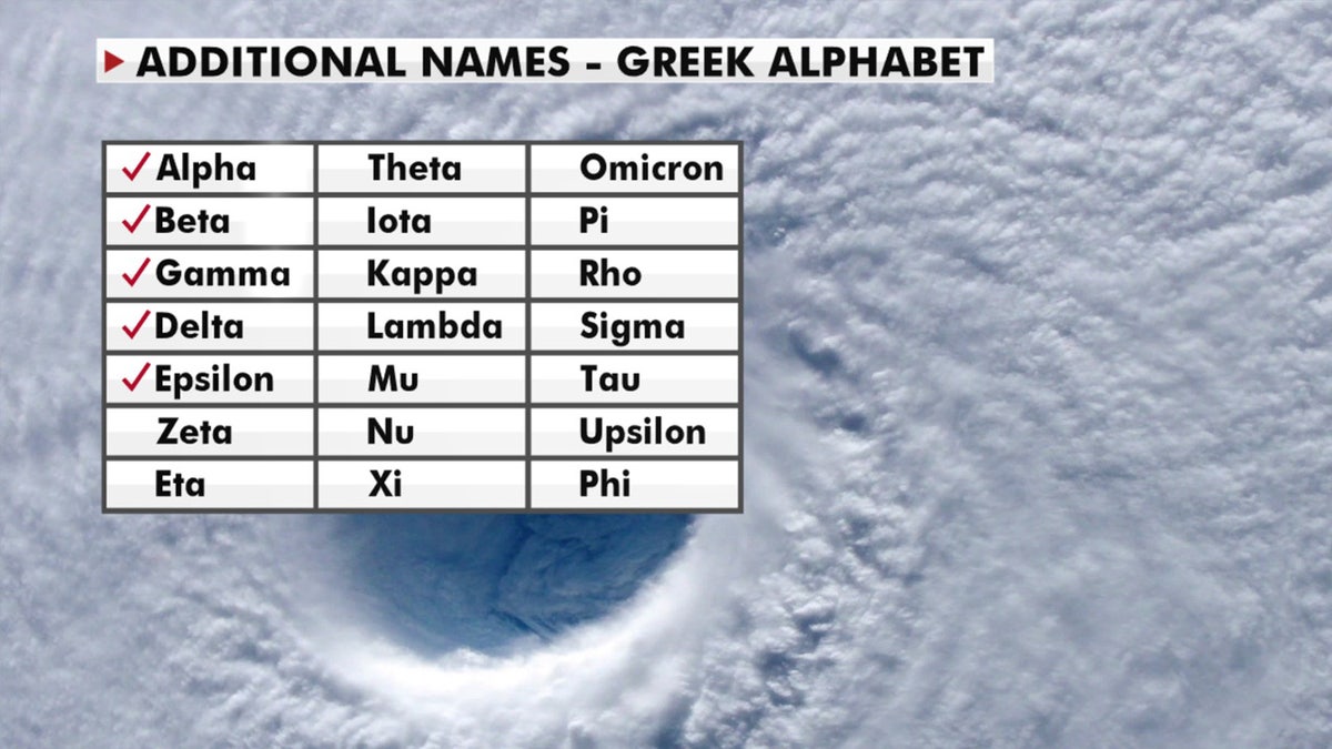
A look at the Greek alphabet names that are being used for the 2020 Atlantic hurricane season, after the hurricane center ran out of official names due to the number of storms. (Fox News)
With a total of 28 storms that year, the first six letters of the Greek alphabet were used: Alpha, Beta, Gamma, Delta, Epsilon, and Zeta.
"We're on track to having the busiest season on record," Dean said Monday.
CLICK HERE FOR THE FOX NEWS APP
Fox News' Adam Klotz and the Associated Press contributed to this report.