(The Weather Channel Satellite Imagery)
For the Latest Updates on Hurricane Irene Go to Fox News Channel's Weather Center.
As Hurricane Irene continues to leave behind a trail of destruction throughout the Caribbean, US officials are warning people to remain alert and to prepare for the first hurricane to seriously threaten the country in almost three years.
The U.S. National Hurricane Center in Miami said Irene was likely to become a major Category 3 hurricane by Wednesday. By Thursday as it roars toward the U.S. coast over warm open waters, it could become a Category 4 with winds of 131 mph (210 kph) or more, NHC hurricane specialist John Cangialosi said late Monday. Winds in such a storm can blow from 131 to 155 mph.
The last hurricane to make landfall in the U.S. was Ike, which pounded Texas in 2008.
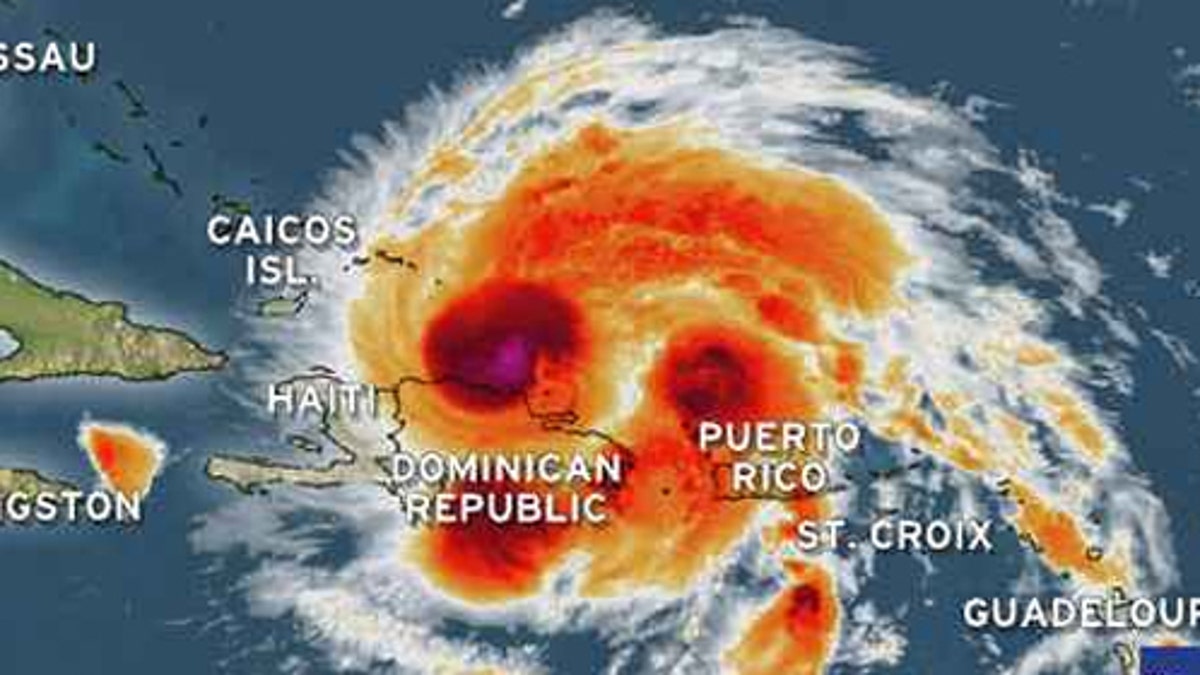
For now, the first Atlantic hurricane of the season had maximum sustained winds early Tuesday around 100 mph (160 kph) and was centered about 50 miles (85 kilometers) northeast of Puerto Plata in the Dominican Republic. The hurricane was moving west-northwest near 12 mph (19 kph) and could eventually land in Florida, Georgia or the Carolinas.
"We want to make sure Floridians are paying attention," said Bryan Koon, director of the Florida Division of Emergency Management, who met Monday with the governor. "We are at the height of the hurricane season right now. If it's not Hurricane Irene, it could be the follow-up storm that impacts us."
After several extremely active years, Florida has not been struck by a hurricane since Wilma raked across the state's south in October 2005. That storm was responsible for at least five deaths in the state and came two months after Hurricane Katrina devastated New Orleans.
"For residents in states that may be affected later this week, it's critical that you take this storm seriously," said Craig Fugate, administrator at the Federal Emergency Management Agency.
Julio González in Miami was heeding the warnings and headed to a hardware store to pick up what he needed to protect his home.
"I'm gonna board up," he said Monday. "It's best to play it safe."
Others were stocking up on bottled water and plywood. And Hurricane Irene was trending on Twitter, with many users sharing updates on the storm's progress while others hoped it wouldn't come their way.
The storm slashed directly across Puerto Rico, tearing up trees and knocking out power to more than a million people. It then headed out to sea, north of the Dominican Republic, where the powerful storm's outer bands were buffeting the north coast with dangerous sea surge and downpours. President Barack Obama declared an emergency for Puerto Rico, making it eligible for federal help.
Irene was forecast to pass over or near the Turks and Caicos Islands and the southeastern Bahamas by Tuesday night and be near the central Bahamas early Wednesday.
In the U.K. territory of the Turks and Caicos, a steady stream of customers bought plywood and nails at hardware stores, while others readied storm shutters and emergency kits at home.
"I can tell you I don't want this storm to come. It looks like it could get bad, so I've definitely got to get my boats out of the water," said Dedrick Handfield at the North Caicos hardware store where he works.
Many of the center's computer models had the storm veering northward away from Florida's east coast toward Georgia and the Carolinas. A hurricane center forecast map said the storm's center could come ashore in one of the states on Saturday or Sunday, but forecasters said much was still unclear.
"In terms of where it's going to go, there is still a pretty high level of uncertainty," said Wallace Hogsett, a National Hurricane Center meteorologist. "It's a very difficult forecast in terms of when it's going to turn northward."
One key reason for that, he said, is the difficulty of measuring how Irene will be affected by the high terrain of the island of Hispaniola, which is shared by Haiti and the Dominican. Hurricane warnings were up on the northern side of the Dominican Republic, as well as the Turks and Caicos islands just south of the long Bahamas chain. Forecasters say it depends on which way the storm veers after passing the Bahamas Tuesday or into Wednesday and heads into the very warm Atlantic waters.
And several past hurricanes have turned into Category 4 or 5 monsters but hit land with much less force.
The other big factor is exactly when the storm will encounter a higher-level trough along the U.S. East Coast, which will eventually turn it to the north.
"Timing is everything," Hogsett said.
In South Carolina, emergency agencies went on alert for what could be the first hurricane to hit there in seven years.
"This is potentially a very serious hurricane," longtime Charleston Mayor Joseph P. Riley Jr. said. He led Charleston's recovery from the massive destruction of Hurricane Hugo's 135 mph winds and waves back in 1989.
Joe Farmer of the state Emergency Management Division said he's not worried about complacency.
"If it does move this way, there will be a lot of public notice given and people will be warned," he said.
It's been more than a century since Georgia has taken a direct hit from a Category 3 storm or greater. That was in 1893 and the last hurricane to make landfall along the state's 100-mile coast was David, which caused only minor damage when it struck in 1979.
Across Florida, emergency management agencies were closely monitoring Irene's movements and track. They urged residents to make sure they have batteries, drinking water, food and other supplies available in case Irene takes aim at the state.
"We must prepare for the worst and hope for the best," said Joe Martinez, chairman of the Miami-Dade County Commission.
Gov. Scott met with state emergency management officials and the state meteorologist, poring over detailed charts involving windspeed and steering currents. Scott, a first-term Republican who has not experienced a hurricane as governor, asked questions such as how much advanced notice would be needed for evacuations of low-lying areas.
"Irene's going to be close," Amy Godsey, the state meteorologist, told Scott. "We're not out of the woods yet."
Scott replied, "I'm an optimist."
Based on reporting by the Associated Press

Fox News' "Antisemitism Exposed" newsletter brings you stories on the rising anti-Jewish prejudice across the U.S. and the world.