


WASHINGTON – Hurricanes seldom get close to Hawaii and it's even rarer for one of the islands to take a direct hit.
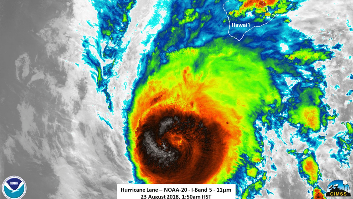
Hurricane Lane is already drenching and pummeling the island chain, even without reaching land.
The last time a major hurricane hit Hawaii was in 1992 when Category 4 Iniki caused billions in damage. On average, the central Pacific hurricane region, which includes Hawaii, sees about four or five storms moving through, but that may be changing with global warming.
A look at the hurricane season in Hawaii:
WIND IS KEY
Usually wind is what keeps storms from threatening Hawaii. Most eastern Pacific hurricanes form in the warm waters off Mexico and head west. But before they get too far, wind currents usually cause them to circle back toward the coast. The storms that stay a bit further south are the rare ones that make it to the central Pacific, said Princeton University climate scientist Gabe Vecchi.
This year, those winds aren't quite steering storms back east. Add to that weaker than normal winds aloft — about where airplanes fly — that usually shred storms. Winds at that level would normally be 23 mph to 29 mph (27 to 47 kph). Now, they are less than half as strong, allowing storms to stay alive, explained Colorado State University hurricane scientist Phil Klotzbach.
That also happened in 2014 and 2015, which were busier than normal years for storms getting close to Hawaii. There were four in 2015 and three in 2014, including Iselle, which hit the Big Island but was a weakened tropical storm.
But the central Pacific is a big area and the islands occupy a small area, so most storms aren't likely to come too close.
WARM WATER
Hurricanes are fueled by warm water. The water temperature in the region is about 2 to 3.5 degrees (1 to 2 degrees Celsius) warmer than normal, according to Vecchi. That was also the case in 2014-2015. "We've come to learn that an unusually warm ocean in the subtropical Pacific will tend to increase the number of hurricanes around Hawaii," Vecchi said.
The Pacific has more storms during a strong El Nino, a weather event that warms the water. Meteorologists expect an El Nino to form in the next couple months, but right now El Nino conditions are still more neutral than hot. Vecchi and others attribute the warming to a natural cousin of El Nino, with help from climate change. When it comes to hurricane activity in the central Pacific, warming from that north-south weather pattern is much more connected to causing more storms than east-west El Nino, Vecchi said.
THE SEASON
So far this year, the entire eastern Pacific region, which includes the central region, is much more active with more storms, stronger ones and longer lasting ones than normal, Klotzbach calculated . On average, the region gets 15 named storms for the total season. Lane, which formed Aug. 15 far off Mexico, is already the 12th named storm and the second to get close to Hawaii. In contrast, the Atlantic region is running around its average for this point in the season, with stormy conditions slowing down recently. Storms get named when winds reach 39 mph (63 kph).
August is the biggest month far for central Pacific hurricanes, compared to September for the Atlantic. The central Pacific hurricane season runs from June through November, just like the Atlantic. The eastern Pacific runs from May through October.
CLIMATE CHANGE
While climate scientists are reluctant to link individual weather events or even seasons to global warming, they can make the connections with elaborate detailed studies. National Oceanic Atmospheric Administration climate scientist Hiro Murakami, Vecchi and others studied the 2014 hurricane season around Hawaii and found it was "made substantially more likely" by climate change caused by emissions from burning coal, oil and gas, with a natural boost from El Nino.
In a study last year, they also connected global warming to 2015's record number of major storms in the region, including three Category 4 hurricanes in the central and eastern Pacific at the same time. These studies are limited because of weak records of storms in the area before 1970, Vecchi said.
WHAT'S AHEAD
Many climate studies recently predict that as the world warms, the globe overall and the Atlantic region will have fewer named storms but more intense ones. However, the central Pacific bucks that prediction.
Several studies forecast that the central Pacific will become busier with more storms, stronger storms and faster developing ones, Vecchi said. A Murakami study used computer simulations to predict a noticeable increase in storms around the Hawaiian Islands.
It's once again because of winds and water. The water in the region is predicted to warm faster than elsewhere around the globe because of a weakening of trade winds, Vecchi said.
___
Follow Seth Borenstein on Twitter: @borenbears . His work can be found here .
___
The Associated Press Health & Science Department receives support from the Howard Hughes Medical Institute's Department of Science Education. The AP is solely responsible for all content.