


Much of Florida's western coast was placed under a tropical storm warning Sunday as Tropical Storm Colin formed in the Gulf of Mexico, as a separate storm system brought severe weather and damaging winds to the Mid-Atlantic region.
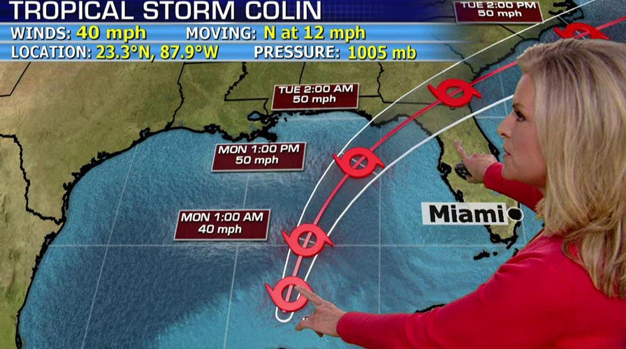
Colin is on course to hit Florida as soon as Monday, according to the National Hurricane Center, which warned the storm could cause serious flooding along much of the state's Gulf coast.
The center added the quickly moving storm is the earliest a third named storm has ever formed in the Atlantic basin.
The storm was moving at a speed of about 12 mph, and was expected to pick up the pace later Sunday.
"It's going to impact most of the state in some way," Gov. Rick Scott told the Associated Press. "Hopefully we won't have any significant issues here, but we can have some storm surge, some rain, tornados and some flooding."
Scott postponed a political meeting with presumptive Republican presidential nominee Donald Trump scheduled Monday in New York so he can remain in the state capital to monitor the weather.
Tropical storms carry wind speeds of between 39 mph and 73 mph.
Tropical Storm Colin is likely to bring dangerous rainfall levels, and residents were warned about possible flooding and hazardous driving conditions. Rain began falling in the Tampa Bay area just past noon on Sunday.
Scott warned residents not to simply look at the center of the storm, saying the heaviest rain will be to the east and west of it.
Several counties in the Tampa Bay area made sandbags available throughout the weekend for residents to prepare for potential flooding, Fox 13 reported.
"We're surrounded on three sides by water," said Pinellas County spokesman Nick Zoller, who said the county distributed 3,300 sand bags on Saturday, a number he expected to go up now that a tropical storm warning is in effect.
Just to the north, Pasco County Emergency Services Director Kevin Guthrie said the message is to be prepared.
"We are going to flood in parts of Pasco County," Guthrie said in an email.
After affecting the Gulf coast of Florida, the Colin is forecast to move northeast. The Georgia coast and the north Florida Atlantic coast were placed under a tropical storm watch Sunday evening.
Colin is the latest in a series of severe whether events across the country, from record-breaking heat in the West, flooding in Texas and storms that are expected to cause problems in the nation's capital and mid-Atlantic region.
The National Weather Service warned of an "enhanced" risk of severe storms in the mid-Atlantic region with the possibility of damaging winds.
Sterling, Virginia-based meteorologist Chris Strong said the primary threat in the Baltimore-Washington metropolitan area is from damaging wind gusts, and there's a lesser threat for tornados.
Wakefield, Virginia-based meteorologist Lyle Alexander says the threat on the Eastern Shore is from winds and more localized heavy rain.
The weather service warns that heavy rain in central Virginia and the Shenandoah Valley could mean flooding in areas that received rain Saturday. Flash flood watches are in effect until evening.
Mount Holly, New Jersey-based meteorologist Lance Franck says in Delaware the threat is from high winds and torrential downpours bringing flooding to urban areas and areas with poor drainage.
In New York City, the last day of a music festival that was to include performances by Kanye West and Death Cab for Cutie was canceled because of weather concerns.
The heavy rain that's been hovering over parts of Southeast and Central Texas and caused deadly flooding began to lift Saturday, but officials said the flooding emergency near the Gulf Coast was worsening and Army officials kept up their investigation of a training exercise that turned deadly at Fort Hood.
In Southeast Texas, water levels began to recede Saturday along upstream portions of the Brazos River, but the peril increased downstream as the water churned toward the Gulf of Mexico.
Emergency officials in Brazoria County warned residents in East Columbia, Bailey's Prairie and Bar-X to be prepared to evacuate their homes.
Except for widely scattered showers in Central and East Texas, the bulk of the rain Saturday was confined to the upper Texas Gulf Coast and the southern tip of Texas.
In Fort Bend County, just southwest of Houston, emergency officials reported seeing slightly improved conditions in flood-struck areas. And while the rain-swollen Brazos has ceased to rise, County Judge Robert Hebert said, some neighborhoods remain cut off by floodwaters and many local streets remain impassable.
The Associated Press contributed to this report.