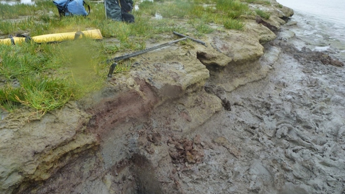
A tidal marsh bank exposed during low tide on Sitkinak Island, Alaska. The bank reveals ledges of alternating peat and silt. Abrupt uplift and subsidence during large megathrust earthquakes is interpreted to be the cause of the alternating laye (Rich Briggs, USGS)
This century's deadly tsunamis kicked off an intense search for buried clues to prehistoric killer waves along Alaska's southern shores. The coastal geology there has unleashed some of the biggest tsunamis in the Pacific Ocean, but the historical record of past earthquakes and waves is sparse.
Now, new evidence uncovered at several spots along the scenic coastline reveals that many tsunamis have flooded Alaska's islands and fjords in the past several thousand years, according to research presented at the Seismological Society of America's annual meeting in Anchorage, Alaska, last week (April 30-May 2).
The findings will help researchers fill the gap in Alaska's earthquake record and improve tsunami prediction models in the Pacific Ocean. Earthquake hazard models, which forecast future shaking, rely on an accurate understanding of the size and location of past earthquakes and tsunamis. The U.S. Geological Survey (USGS) is currently updating its seismic hazard map for Alaska.
"There seems to be more frequent tsunami inundation than the models presume, but that's because we have no data," said Rich Briggs, a USGS researcher who was involved in the studies.
Mega-earthquakes along Alaska's subduction zone send deadly waves throughout the Pacific Rim (countries bordering the Pacific Ocean), primarily affecting Hawaii and the west coast of North America. Alaska's subduction zone, where the Pacific and North America tectonic plates collide, unleashed the second most powerful earthquake ever recorded, in 1964.
[Gallery: The 1964 GreatAlaska Earthquake]
"Ultimately, we hope our research helps Alaskans and coastal communities around the Pacific Ocean prepare for future tsunamis and thereby reduce the tragic losses like those witnessed in recent disasters," said Rob Witter, a research geologist at the U.S. Geological Survey's Alaska Science Center, who was a study co-author.
Search for sand
Witter and his colleagues presented evidence for several past tsunamis in the so-called Unalaska seismic gap. A "seismic gap" is jargon for a portion of a fault that has not produced an earthquake in recent history, even though surrounding sections have unzipped.
Nearly all of the Alaska-Aleutian megathrust, the name for the subduction zone fault, has ruptured in the past 100 years, producing earthquakes stronger than magnitude 8, but the Unalaska seismic gap has not done so.
At Umnak Island in the Unalaska seismic gap, Witter and his colleagues discovered drift logs stranded up to 75 feet (23 meters) above sea level. There were sand deposits in the island's marshes from nine past tsunamis in the last 2,200 years. The team also found evidence of six past tsunamis on nearby Sedanka Island in the last 1,600 years. The tsunami sediments imply repeated earthquakes in the Unalaska seismic gap every 280 to 325 years, Witter said. (By modeling potential seismic wave sources, geologists can determine whether a tsunami was likely triggered by a landslide or an earthquake.) A separate USGS study reported six tsunamis in the past 1,770 years on Unalaska Island, which is also in the Unalaska seismic gap.
The drift logs, combined with evidence for several prior tsunamis, suggest that the Unalaska seismic gap isn't a gap at all, Witter told Live Science's Our Amazing Planet. Instead, this part of the fault broke in 1957 during the magnitude-8.6 Andreanof Islands earthquake, he said. (Thanks to an early warning system, the tsunami from this quake did not cause any deaths, though it did destroy buildings and boats along beaches in Alaska and Hawaii.)
A true gap
Farther east, however, the Shumagin seismic gap seems to be one of the calmest zones along this hazardous fault. In a separate study, Simeonof Island within the gap shows no evidence of uplift (or land-level change) from earthquakes in the past 3,400 years, nor signs of damaging tsunamis, Witter and his colleagues reported April 9 in the journal Geophysical Research Letters.
Instead of rupturing in large earthquakes, the Shumagin gap looks to be creeping, a type of movement in which each side of a fault slides past the other without storing up powerful earthquake energy. The central segment of the San Andreas fault also creeps, as do portions of Indonesia's subduction zone near the Batu Islands, Briggs said.
While evidence for earthquakes in the Shumagin seismic gap could be buried offshore, the lack of evidence for changes in height or for tsunamis limits the possibility that mega-earthquakes occurred in the gap, the researchers said.
"We found no evidence of great earthquakes in the Shumagin seismic gap in the past 3,400 years," Witter said. If such events had occurred, "the earthquake and its tsunami would have left clues along the shoreline."

Get a daily look at what’s developing in science and technology throughout the world.