Hurricane Dorian tracks north as Tropical Storm Fernand forms in Gulf of Mexico
Fox News chief meteorologist Rick Reichmuth tracks both storm from the Fox Extreme Weather Center.
The sixth named tropical system of the Atlantic hurricane season is expected to dump a deluge on Mexico's upper Gulf Coast on Wednesday, as another tropical system has formed in the far-out Atlantic Ocean. Meanwhile, Hurricane Dorian lurks off the Southeast coast of the U.S.
The National Hurricane Center said Tropical Storm Fernand made landfall along the northeast coast of Mexico around 12:15 p.m. EDT. The storm has maximum sustained winds of 45 mph and was located about 35 miles southeast of La Pesca, Mexico. The storm was moving west-northwest at 8 mph, according to the NHC.
A tropical storm warning is in effect from Puerto Altamira to the mouth of the Rio Grande River on the U.S. border.
TROPICAL STORM FERNAND THREATENS MEXICO; TRIPLE THREAT SEEN AS HURRICANE SEASON NEARS PEAK
Tropical storm-force winds extend outward up to 105 miles from the center of the storm, which is forecast to rapidly weaken and dissipate by Thursday.
Forecasts said the storm could drop 6 to 12 inches of rain, with as much as 18 inches in isolated spots along the coast and in the Sierra Madre Oriental range. Fernand is expected to bring 2 to 4 inches of rain in South Texas.
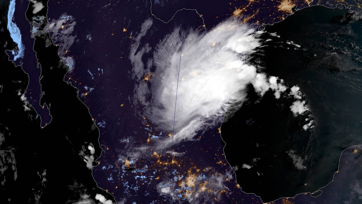
This image, taken on Wednesday, Sept. 4, 2019, shows Tropical Storm Fernand in the Gulf of Mexico off northeast Mexico. (NOAA/GOES-East)
"Interests along the lower Texas coast should monitor the progress of this system," the NHC said.
Meanwhile, Hurricane Juliette was moving away from shore and weakening far off Mexico's Pacific coast. A satellite photo from NOAA shows the scale of tropical activity in the Atlantic and Pacific oceans at the moment.
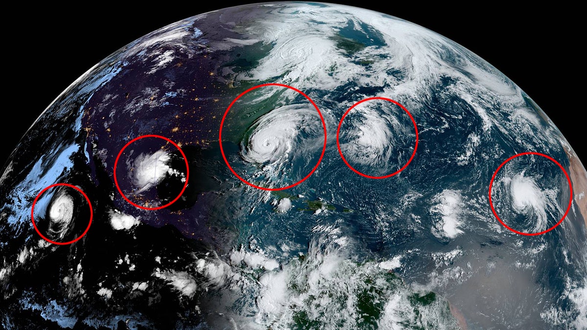
This image, taken on Wednesday, Sept. 3, 2019, shows tropical activity in the Pacific and Atlantic Oceans. (NOAA/GOES-East)
Hours after the NHC said that Fernand formed in the Gulf of Mexico, forecasters announced a seventh storm had formed in the eastern tropical Atlantic.
Tropical Storm Gabrielle is swirling in the open Atlantic Ocean with 40 mph winds about 680 miles west-northeast of the Cabo Verde Islands, moving northwest at 10 mph.
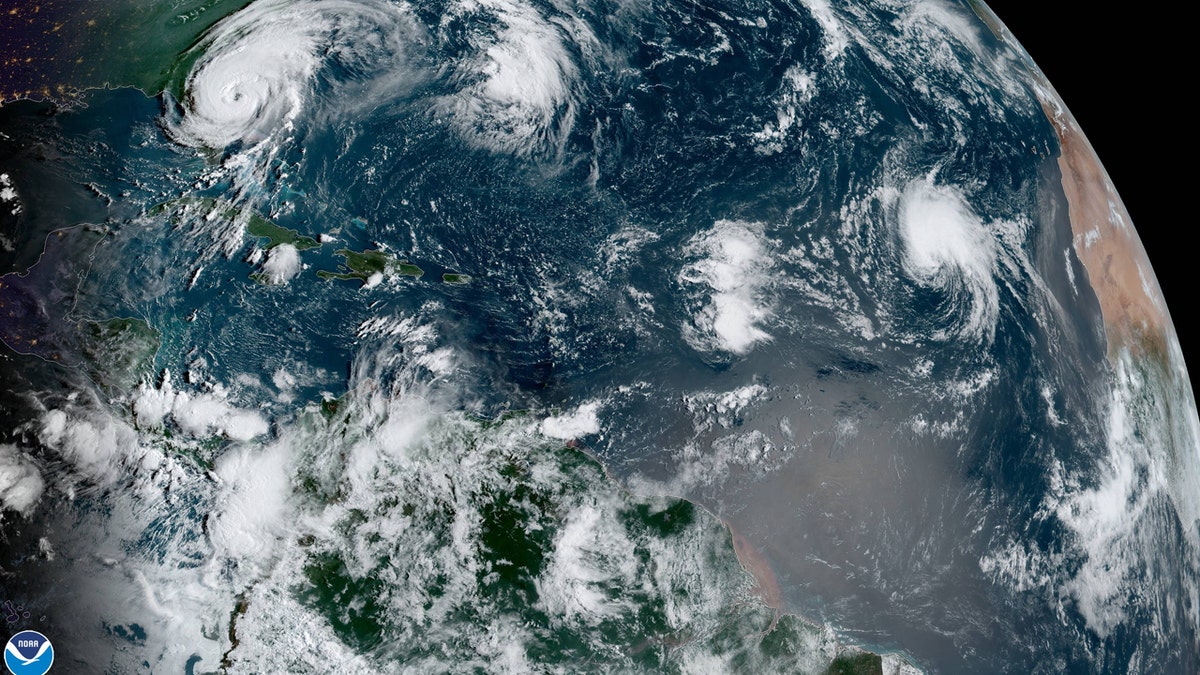
This image, taken on Wednesday, Sept. 4, 2019, shows Tropical Storm Gabrielle in the far-east Atlantic as Hurricane Dorian can be seen spinning just off the coast of Florida. (NOAA/GOES-East)
The storm is forecast to keep moving northwest through Friday, with an increase in forward speed and some slight strengthening.
Gabrielle, however, does not post any immediate risk to land, according to forecasters.
CLICK HERE FOR THE FOX NEWS APP
The latest tropical activity in the Atlantic Basin comes ahead of the climatological peak for hurricane season, which is Sept. 10, according to Fox News Chief Meteorologist Rick Reichmuth.
NOAA forecasters have called for 10-17 named storms in the Atlantic, of which five to nine could strengthen into hurricanes. Of those storms, there will be two to four major hurricanes, which are classified as Category 3, 4, and 5 with winds of 111 mph or higher.
The 2019 Atlantic Hurricane Season runs from June 1 to Nov. 30, and this year includes the names Andrea, Barry, Chantal, Dorian, Erin, Fernand, Gabrielle, Humberto, Imelda, Jerry, Karen, Lorenzo, Melissa, Nestor, Olga, Pablo, Rebekah, Sebastien, Tanya, Van and Wendy.

Fox News' "Antisemitism Exposed" newsletter brings you stories on the rising anti-Jewish prejudice across the U.S. and the world.