


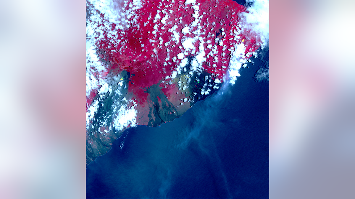
NASA's Terra satellite captured this image of Hawaii's erupting Kilauea volcano on May 6, 2018, using its Advanced Spaceborne Thermal Emission and Reflection Radiometer (ASTER) instrument. The yellow-green "hotspots" are newly formed fissures and lava flows; red is vegetation, and the gray-black areas are old lava flows. (NASA/METI/AIST/Japan Space Systems, and US/Japan ASTER Science Team)
You can get a bird's-eye view of Hawaii's ongoing volcanic outburst, thanks to two newly released satellite photos.
The Kilauea volcano on the Big Island of Hawaii has been erupting continuously for more than 30 years, but this background activity flared up significantly late last week after a powerful earthquake struck the island.
A dozen new volcanic fissures have since opened up on Kilauea's flanks, and the combination of flowing lava and noxious gases has forced the evacuation of more than 1,500 people (though there have been no reports of serious injuries to date). [Photos: Fiery Lava from Kilauea Volcano Erupts on Hawaii's Big Island]
In one of the images, these new fissures and flows stand out as bright green and yellow hotspots surrounded by seas of red (vegetation) and gray-black (old, cold lava).
More From Space.com
The other photo shows huge plumes of sulfur dioxide gas, also represented by yellow and green hues, wafting away from volcanic vents.
Both images were captured on Sunday (May 6) by the Advanced Spaceborne Thermal Emission and Reflection Radiometer (ASTER) instrument aboard NASA's Terra satellite. As the name suggests, ASTER can detect light in thermal infrared wavelengths — basically, heat.
The Terra satellite launched to Earth orbit in December 1999, on a mission to monitor the planet's climate and other large-scale processes and to help scientists better understand humanity's impact on ecosystems.
As the new photos show, Terra data can additionally help researchers, government officials and first responders prepare for and deal with natural disasters. ASTER also images wildfires, and another one of Terra's five science instruments, the Moderate Resolution Imaging Spectroradiometer (MODIS), commonly keeps tabs on hurricanes as they churn toward populated areas. (A MODIS instrument also flies aboard Terra's sister satellite, the Earth-observing Aqua spacecraft.)
Originally published on Space.com.