
Tropical Storm Arthur approaches North Carolina coastline
Fox News senior meteorologist Janice Dean provides storm forecast.
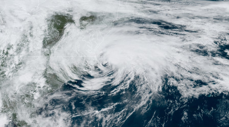
The first named storm of the 2020 Atlantic hurricane season lashed eastern North Carolina with rain and gusty winds on Monday, as the tropical storm made a close pass at the state's Outer Banks.
The U.S. National Hurricane Center (NHC) said as of 2 p.m. EDT on Monday that Tropical Storm Arthur is located about 55 miles east-northeast of Cape Hatteras, moving northeast at 16 mph with maximum sustained winds of 50 mph.
"The full center of the storm is going to remain offshore but we're still going to get indirect impacts," Fox News senior meteorologist Janice Dean said Monday on "Fox & Friends First." "The rain and the wind, as it continues to move north and eastward."
TROPICAL STORM ARTHUR JOINS RECENT STORMS THAT DEVELOPED BEFORE HURRICANE SEASON STARTS
Tropical storm warnings had been posted from Surf City to Duck, N.C., including the Pamlico and Albemarle Sounds. They now stretch from Ocracoke Inlet to Duck, and still include the sounds.
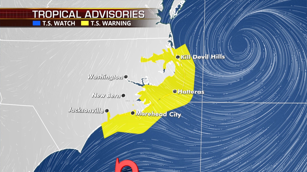
Tropical storm warnings have been posted in Eastern North Carolina as Tropical Storm Arthur makes a close pass on Monday.
"On the forecast track, the center of Arthur will continue to move away from the North Carolina Outer Banks this afternoon," the NHC said.
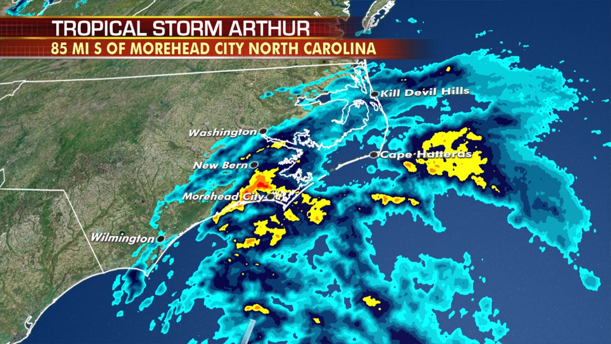
Tropical Storm Arthur is bringing heavy rain and gusty winds to Eastern North Carolina on Monday. (Fox News)
Eastern North Carolina and the Outer Banks were seeing increasing wind gusts and rain as of Monday morning as the center of Arthur passed offshore.
Arthur remains a minimal tropical storm, with maximum sustained winds of 50 mph. The NHC said tropical-storm-force winds extend outward up to 125 miles, mainly to the east of the center of Arthur over water.
"We could see wind gusts, or feel wind gusts, upwards of 50 to 60 mph, and then it's going to start to make its curve," Dean said.
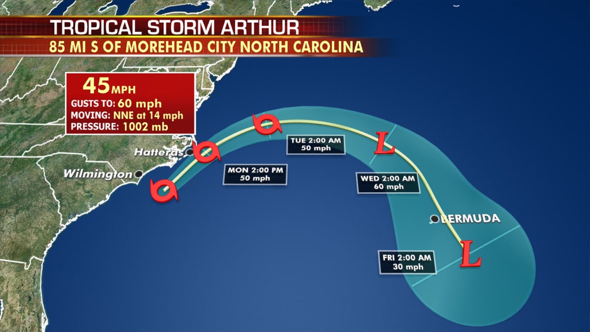
The forecast track of Tropical Storm Arthur. (Fox News)
Throughout the day on Monday, gusts to 50 mph are possible along the Outer Banks through midday with between one to three inches of rain. Isolated maximum amounts of up to five inches of rain are possible in coastal areas.
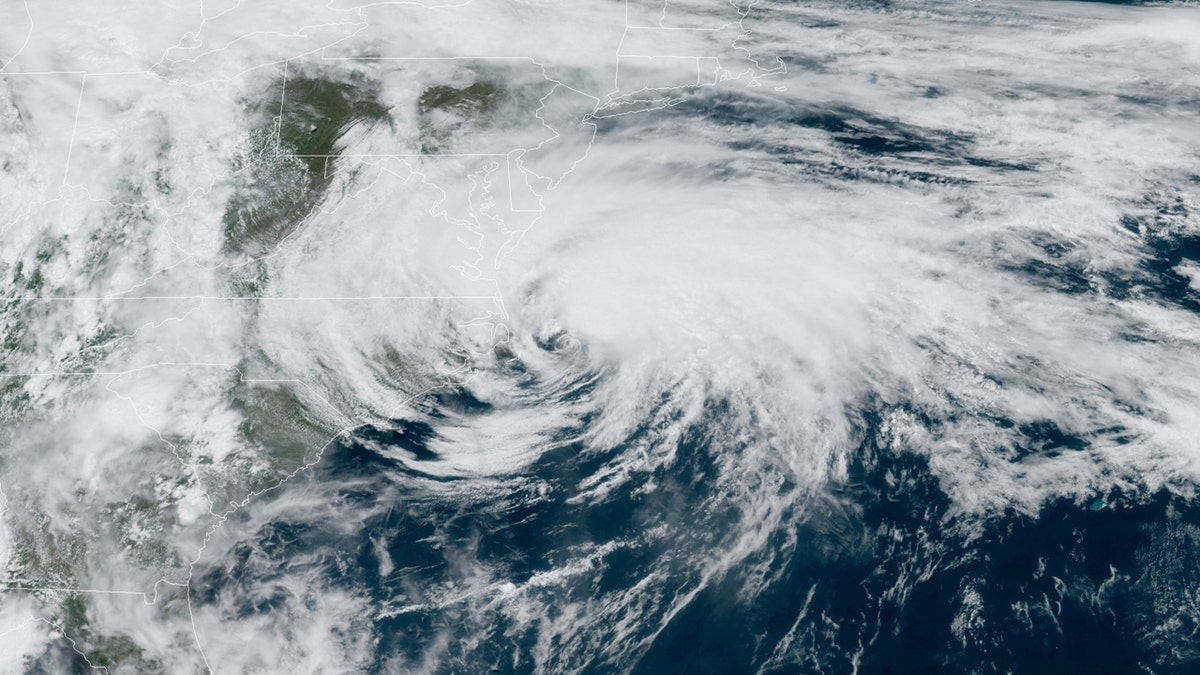
Tropical Storm Arthur can be seen swirling off the North Carolina coast on Monday, May 18, 2020. (NOAA/GOES East)
The National Weather Service (NWS) said eastern North Carolina should prepare for some localized flooding and dangerous marine conditions along the coast.
TROPICAL STORM WATCH VS. TROPICAL STORM WARNING: HERE'S THE DIFFERENCE
"Minor inundation from storm surge is possible for very low-lying areas adjacent to the ocean, sounds, and rivers, with overwash of dunes and flooding of properties and roadways possible for locations where dune structures are weak," mainly north of Cape Lookout, the weather service said.
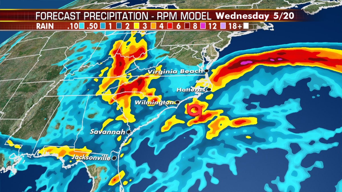
Several inches of rain are forecast for parts of Eastern North Carolina on Monday due to Tropical Storm Arthur. (Fox News)
Forecasters from the NHC said very slight strengthening is possible over the next 24 hours. Arthur is then forecast to turn away from the east coast of the U.S. from Monday night into Tuesday.
"We expect it could strengthen a little bit today and Tuesday and then Bermuda is going to have to watch an extra-tropical low," Dean said on "Fox & Friends First."
Rough surf and rip currents will continue along the Southeast and mid-Atlantic coasts for the next few days as Arthur moves into the ocean and transitions to a non-tropical low on Tuesday.
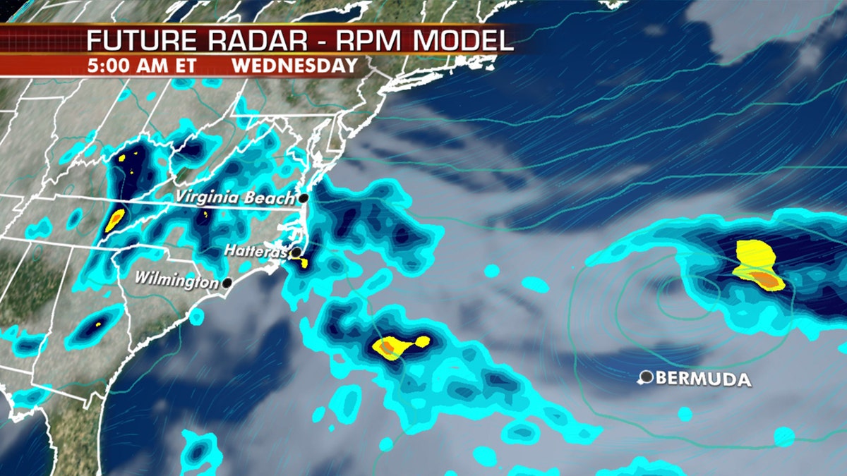
Rough surf and rip currents will continue along the Southeast and Mid-Atlantic coasts for the next few days as Arthur moves into the Atlantic. (Fox News)
"These swells could cause life-threatening surf and rip current conditions," the NHC said.
North Carolina Gov. Roy Cooper has urged residents along the coast to pay close attention to the storm and "don’t take chances in dangerous surf."
CLICK HERE FOR MORE WEATHER COVERAGE FROM FOX NEWS
Tropical Storm Arthur formed Saturday night, making it the sixth-straight year for a system to develop before the official start of hurricane season on June 1.
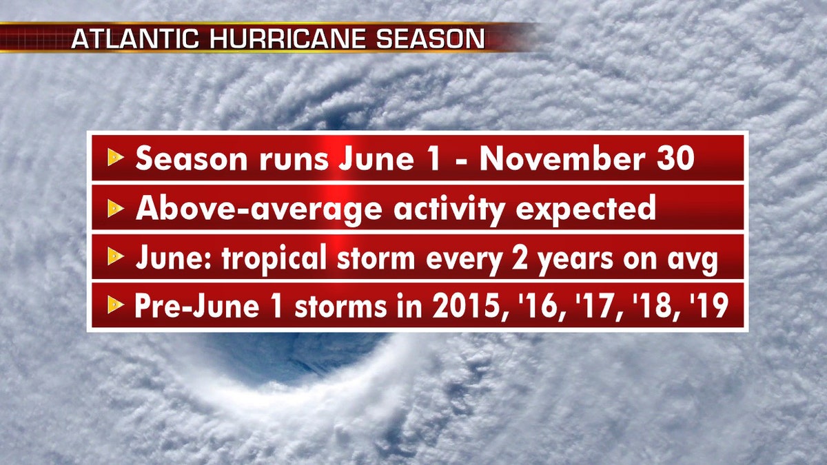
What to know about the approaching Atlantic hurricane season. (Fox News)
Even though the Atlantic Basin season officially runs from June 1 to Nov. 30, plenty of May storms have developed in recent years. In fact, the first named storm of the season has been in May every year since 2015.
"So just a reminder that hurricane season is upon us even though it's early this season," Dean said Monday. "Officially, it's June 1. Of course, early-named storms ... it's happened several years in a row, including last year."

The names for the 2020 Atlantic hurricane season. (Fox News)
While the National Oceanic and Atmospheric Administration Climate Prediction Center will provide its seasonal outlook for the Atlantic basin on May 21, researchers at Colorado State University are predicting an above-average hurricane season this year, citing the likely absence of El Niño as a primary factor.
CLICK HERE FOR THE FOX NEWS APP
The 2020 Atlantic hurricane season will include the names: Arthur, Bertha, Cristobal, Dolly, Edouard, Fay, Gonzalo, Hanna, Isaias, Josephine, Kyle, Laura, Marco, Nana, Omar, Paulette, Rene, Sally, Teddy, Vicky, and Wilfred.
The Associated Press contributed to this report.

The hottest stories ripped from the headlines, from crime to courts, legal and scandal.
