Thunderstorms in New Orleans cause major flash flooding
City hall was forced to close, residents asked to avoid driving through flooded areas.
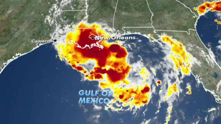
A hurricane may come to Louisiana by week's end, something that could raise the Mississippi River to the brim of the protective levees of New Orleans.
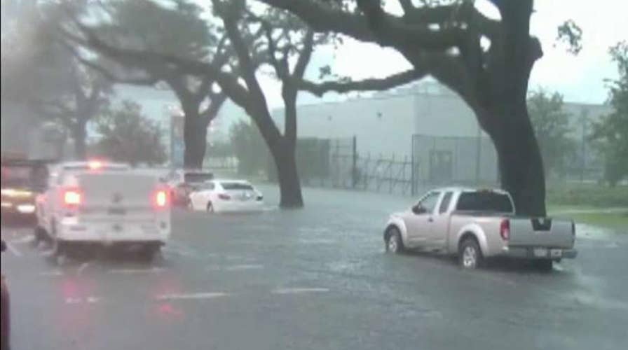
A major storm has currently swamped the city’s streets, and it paralyzed traffic Wednesday.
The storm was associated with an atmospheric disturbance in the Gulf that forecasters said was on track to strengthen into a hurricane by the weekend. The National Hurricane Center expected the system to become a tropical depression by Thursday morning, a tropical storm by Thursday night and a hurricane on Friday.
Lines of thunderstorms ranged far out into the Gulf and battered New Orleans, where as much as 8 inches of rain fell over a three-hour period Wednesday morning, officials said.
2019 ATLANTIC HURRICANE SEASON TO BE 'NEAR-NORMAL' WITH 9 TO 15 NAMED STORMS, NOAA SAYS
Plaquemines Parish issued a state of emergency out of precaution.
“Plaquemines Parish Government has taken all precautions in preparing for Tropical Storm Barry,” said the parish’s presidentKirk Lepine. “Additional rainfall, high winds and storm surge are expected.”
Wednesday’s flooding was reminiscent of floodwaters that surprised the city during an August 2017 rain. That flood exposed major problems at the agency overseeing street drainage. It led to personnel shakeups at the New Orleans Sewerage and Water Board and required major repair efforts.
On Wednesday, the board said 118 of 120 drainage pumps were operational and the agency was fully staffed. But the agency’s director says that much rain in such a short time would have overwhelmed any drainage system.
Mississippi and Texas were also at risk of torrential rains.
In New Orleans, streets turned into small, swift rivers that overturned garbage cans and picked up pieces of floating wood. Water was up to the doors of many cars. Other vehicles were abandoned. Kayakers paddled their way down some streets.
Gov. John Bel Edwards declared a state of emergency and said National Guard troops and high-water vehicles would be positioned all over the state in advance of more heavy rain.
“The entire coast of Louisiana is at play in this storm,” Edwards said.
Forecasters said Louisiana could see up to 12 inches of rain by Monday, with isolated areas receiving as much as 18 inches.
The additional rain could push the already swollen Mississippi River precariously close to the tops of levees that protect New Orleans, officials said.
“We’re confident the levees themselves are in good shape. The big focus is height,” spokesman Ricky Boyett said.
CLICK HERE FOR THE FOX NEWS APP
A spokesman for the Army Corps of Engineers in New Orleans said the agency was not expecting widespread overtopping of the levees, but there are concerns for areas south of the city. The river was expected to rise to 20 feet by late Friday at a key gauge in New Orleans. The area is protected by levees 20 to 25 feet high, he said.
The corps was working with local officials to identify any low-lying areas and reinforce them, he said.
The Associated Press contributed to this report.

The hottest stories ripped from the headlines, from crime to courts, legal and scandal.
